
ಟೇಬಲ್ ಪರ್ವತ
| Table Mountain | |
|---|---|
 View of Table Mountain and Cape Town seen from Bloubergstrand. Table Mountain is flanked by Devil's Peak on the left and Lion's Head on the right. | |
| Highest point | |
| ಎತ್ತರ | 1,084.6 m (3,558 ft)[೧] |
| ಪ್ರಾಮುಖ್ಯತೆ | 1,055 m (3,461 ft) |
| ಪಟ್ಟಿ | List of mountains in South Africa |
| ನಿರ್ದೇಶಾಂಕಗಳು | 33°57′26.33″S 18°24′11.19″E / 33.9573139°S 18.4031083°E |
| Geography | |
Lua error in ಮಾಡ್ಯೂಲ್:Location_map at line 525: Unable to find the specified location map definition: "ಮಾಡ್ಯೂಲ್:Location map/data/South Africa" does not exist.
| |
| Geology | |
| ಬಂಡೆಯ ವಯಸ್ಸು | Silurian/Ordovician |
| ಪರ್ವತ ಪ್ರಕಾರ | Sandstone |
| Climbing | |
| ಮೊದಲ ಆರೋಹಣ | António de Saldanha, 1503 |
| ಸುಲಭವಾದ ಮಾರ್ಗ | Platteklip Gorge |
ಟೇಬಲ್ ಪರ್ವತ - ದಕ್ಷಿಣ ಆಫ್ರಿಕದಲ್ಲಿ ಕೇಪ್ ಟೌನಿಗೆ ದಕ್ಷಿಣದಲ್ಲಿ ಮೇಜಿನಂತಿರುವ ಚಪ್ಪಟೆ ತಲೆಯ ಪರ್ವತ. ಎತ್ತರವಾದ ಬಂಡೆಗಳಿಂದ ಕೂಡಿದ ಕೇಪ್ ಪರ್ಯಾಯ ದ್ವೀಪದ ಉತ್ತರ ತುದಿ.
ರಚನೆ[ಬದಲಾಯಿಸಿ]

ಇದರ ಮರಳುಗಲ್ಲಿನ ಗಟ್ಟಿಯಾದ ಮತ್ತು ದಟ್ಟವಾದ ಬಂಡೆಯಿಂದಾಗಿ ಇದಕ್ಕೆ ಮೇಜಿನ ಆಕಾರ ಬಂದಿದೆ. ನೀರಿನ ಹಾಗೂ ಗಾಳಿಯ ತೀವ್ರ ಕೊರತೆಯಿಂದ ಇದರ 3.22ಕಿ.ಮೀ ಉದ್ದದ ಉತ್ತರಮುಖ ಗೋಡೆಯಂತೆ ಕಡಿದಾಗಿ ಪರಿಣಮಿಸಿದೆ. ಈ ಪರ್ವತ ಪ್ರಸ್ಥಭೂಮಿಯ ಎತ್ತರ ಸುಮಾರು 1,065ಮೀ. ಇದರ ಹಿಂಬದಿಯಲ್ಲಿ ಅಲ್ಲಲ್ಲಿ ಆಳವಾಗಿ ಕತ್ತರಿಸಲ್ಪಟ್ಟ ಸ್ವಲ್ಪ ತಗ್ಗಿನ ಪ್ರಸ್ಥಭೂಮಿಯ ಇದೆ. ಟೇಬಲ್ ಪರ್ವತದ ಅತ್ಯುನ್ನತ ಸ್ಥಳ ಮ್ಯಾಕ್ಲಿಯರ್ ಬೀಕನ್ 1,087 ಮೀ. ಭೂಸವೆತದಿಂದಾಗಿ ಮುಖ್ಯ ಪರ್ವತಭಾಗದಿಂದ ಪ್ರತ್ಯೇಕವಾಗಿರುವ ಎರಡು ಶಿಖರಗಳಲ್ಲಿ ಒಂದು ಡೆವಿಲ್ಸ್ ಶಿಖರ 997ಮೀ ಇದು ಈಶಾನ್ಯದಲ್ಲಿದೆ. ವಾಯುವ್ಯಕ್ಕಿರುವುದು ಲೈಯನ್ ಹೆಡ್ ಶಿಖರ 664ಮೀ.
ಹವಾಮಾನ[ಬದಲಾಯಿಸಿ]
ಟೇಬಲ್ ಪರ್ವತದ ಮೇಲೆ ಬೀಸುವ ಆಗ್ನೇಯ ಮಾರುತಗಳು ತರುವ ಹಸಿರು ಮಿಶ್ರಿತ ಬಿಳಿ ಮೋಡಗಳು ಪರ್ವತಾಗ್ರವನ್ನೂ ಪೂರ್ವದ ಬದಿಯನ್ನು ಆಗಾಗ ದಟ್ಟವಾಗಿ ಕವಿಯುವುದುಂಟು. ಇದು ಮೇಜಿನ ಮೇಲೆ ಹರವಿದ ಬಟ್ಟೆಯಂತಿರುವುದರಿಂದ ಇದನ್ನು ಟೇಬಲ್ ಕ್ಲಾತ್ ಎಂದು ಕರೆಯುತ್ತಾರೆ. ಮಳೆ ಬರುವುದು ಬಹುತೇಕ ವಾಯುವ್ಯ ಮಾರುತಗಳಿಂದ. ಚಳಿಗಾಲದಲ್ಲಿ, ಸ್ಥಳದಿಂದ ಸ್ಥಳಕ್ಕೆ ಮಳೆಯ ಪರಿಮಾಣ ಬದಲಾಗುತ್ತದೆ; ನೆತ್ತಿಯ ಮೇಲೆ 60” ಮಿಮೀ.; ಪರ್ವತದ ತಪ್ಪಲಿನಲ್ಲಿ ಕೇಪ್ ಟೌನಿನ ಕೆಲವು ಭಾಗಗಳ ಮೇಲೆ 560ಮಿಮೀ. ಪರ್ವತದ ಮೇಲಿರುವ ಐದು ಜಲಾಶಯಗಳಿಂದ ಕೇಪ್ ಟೌನಿಗೆ ನೀರು ಸರಬರಾಯಿ ಆಗುತ್ತದೆ.
ಸಸ್ಯಗಳು[ಬದಲಾಯಿಸಿ]
ಟೇಬಲ್ ಪರ್ವತದ ಮೇಲೆ ಹೆಚ್ಚಾಗಿ ಮಳೆ ಬೀಳುವ ಪ್ರದೇಶಗಳಲ್ಲಿ ಪ್ರೋಟೀಯ, ಹೀತ್, ಡಿಸಾ ಸೀತೆ ಹೂವಿನ ಗಿಡ ಮುಂತಾದವು ವಿಶೇಷವಾಗಿ ಬೆಳೆಯುತ್ತವೆ. ಡೇಸಿ ಪರಿವಾರದ ಅನೇಕ ಸ್ಥಳೀಯ ಜಾತಿಗಳ ಸಸ್ಯಗಳೂ ಉಂಟು. ಹೆಚ್ಚು ಮಳೆ ಬೀಳದ ಪಶ್ಚಿಮ ಪಾಶ್ರ್ವದಲ್ಲಿ ಮಾಂಸಲ ಸಸ್ಯಗಳುಂಟು. ಸ್ಪಿಂಕ್ವುಡ್, ಯೆಲ್ಲೋವುಡ್, ಸಿಲ್ವರ್ ಮರ ಮುಂತಾದವು ಕಾಡುಗಳಲ್ಲಿ ಬೆಳೆಯುತ್ತವೆ.
ಪ್ರವಾಸೋದ್ಯಮ[ಬದಲಾಯಿಸಿ]
ಪರ್ವತದ ಮೇಲಕ್ಕೆ ಸು.300 ಹಾದಿಗಳುಂಟು. 1929ರಲ್ಲಿ ಇಲ್ಲಿಗೆ ಹೊರಜಿ ಮಾರ್ಗ ಏರ್ಪಡಿಸಲಾಯಿತು. ಇದರ ಮೂಲಕ ಪ್ರತಿ ವರ್ಷವೂ ಸು.50,000 ಮಂದಿ ಪರ್ವತದ ಮೇಲಕ್ಕೆ ಹೋಗಿ ಬರುತ್ತಾರೆ
ಛಾಯಾಂಕಣ[ಬದಲಾಯಿಸಿ]
-
 View from Signal Hill with Devil's Peak to the left
 -
 Upper Cable Station from the summit of Lion's Head
 -
 The cable car with Robben Island in the background
 -
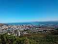
 Cape Town, Signal Hill, Table Bay and Robben Island as seen from the upper cable station of the Table Mountain Cableway.
 -
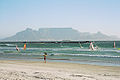 Table Mountain and Cape Town seen from Bloubergstrand.
 -
 The concrete part of the Bridle Path—the most gradually-inclined route to the Back Table
 -
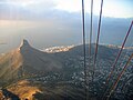
 Cape Town and Table Bay from the slopes of Devil's Peak, showing some of the mountain biking jeep tracks.
 -
 Cape Town's beach, the Atlantic Ocean, and Table Mountain.
 -
 The Upper Cable Station as seen on your way up from the cable car.
 -
 Lion's Head as seen from Table Mountain cable car.
 -
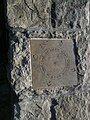 Time is a Gift, one of several plaques at the top of Table Mountain
 -
 The Table Cloth draped over the north facing slopes
 -
 View of Table Mountain from Blouberg beach.
 -
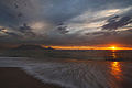 View of Table Mountain at sunset.
 -
 As seen from the other side of Table Bay at sunset.


ಬಾಹ್ಯಸಂಪರ್ಕಗಳು[ಬದಲಾಯಿಸಿ]
- Table Mountain National Park official site
- South African Hiking Trail Guide Archived 2019-01-02 ವೇಬ್ಯಾಕ್ ಮೆಷಿನ್ ನಲ್ಲಿ.
- ↑ Chief Directorate: National Geo-spatial Information (2000). 3318CD Cape Town (Map). 1:50,000. Topographical (9th ed.).