
ಚಿತ್ರ:Accreting coast Image6.svg

Size of this PNG preview of this SVG file: ೮೦೦ × ೩೭೭ ಪಿಕ್ಸೆಲ್ಗಳು. ಇತರ ರೆಸಲ್ಯೂಶನ್ಗಳು: ೩೨೦ × ೧೫೧ ಪಿಕ್ಸೆಲ್ಗಳು | ೬೪೦ × ೩೦೧ ಪಿಕ್ಸೆಲ್ಗಳು | ೧,೦೨೪ × ೪೮೨ ಪಿಕ್ಸೆಲ್ಗಳು | ೧,೨೮೦ × ೬೦೨ ಪಿಕ್ಸೆಲ್ಗಳು | ೨,೫೬೦ × ೧,೨೦೫ ಪಿಕ್ಸೆಲ್ಗಳು | ೧,೪೮೧ × ೬೯೭ ಪಿಕ್ಸೆಲ್ಗಳು.
ಮೂಲ ಕಡತ (SVG ಫೈಲು, ಸುಮಾರಾಗಿ ೧,೪೮೧ × ೬೯೭ ಚಿತ್ರಬಿಂದುಗಳು, ಫೈಲಿನ ಗಾತ್ರ: ೧೫ KB)
ಈ ಫೈಲು ವಿಕಿಮೀಡಿಯ ಕಾಮನ್ಸ್ನಲ್ಲಿ ಇರುವುದು. ಅಲ್ಲಿನ ವಿವರಣೆ ಪುಟವನ್ನೇ ಕೆಳಗೆ ತೋರಿಸಲಾಗಿದೆ. ಕಾಮನ್ಸ್ ಕೃತಿಸ್ವಾಮ್ಯತೆಯಿಂದ ಮುಕ್ತ ಫೈಲುಗಳ ಒಂದು ಆಗರ. ಅಲ್ಲಿ ನೀವೂ ಸಹಕರಿಸಬಹುದು. |
ಸಾರಾಂಶ
| ವಿವರ |
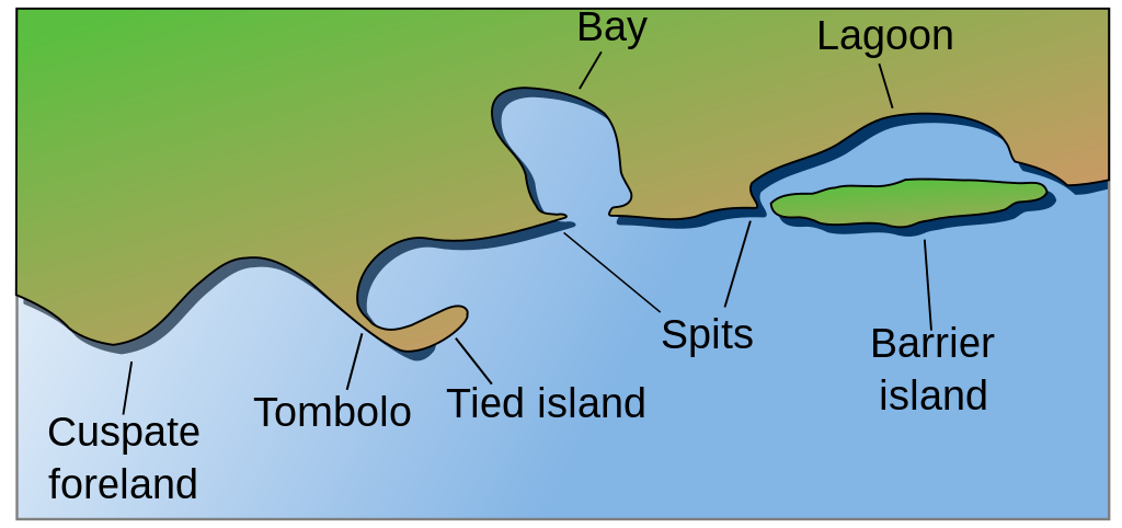
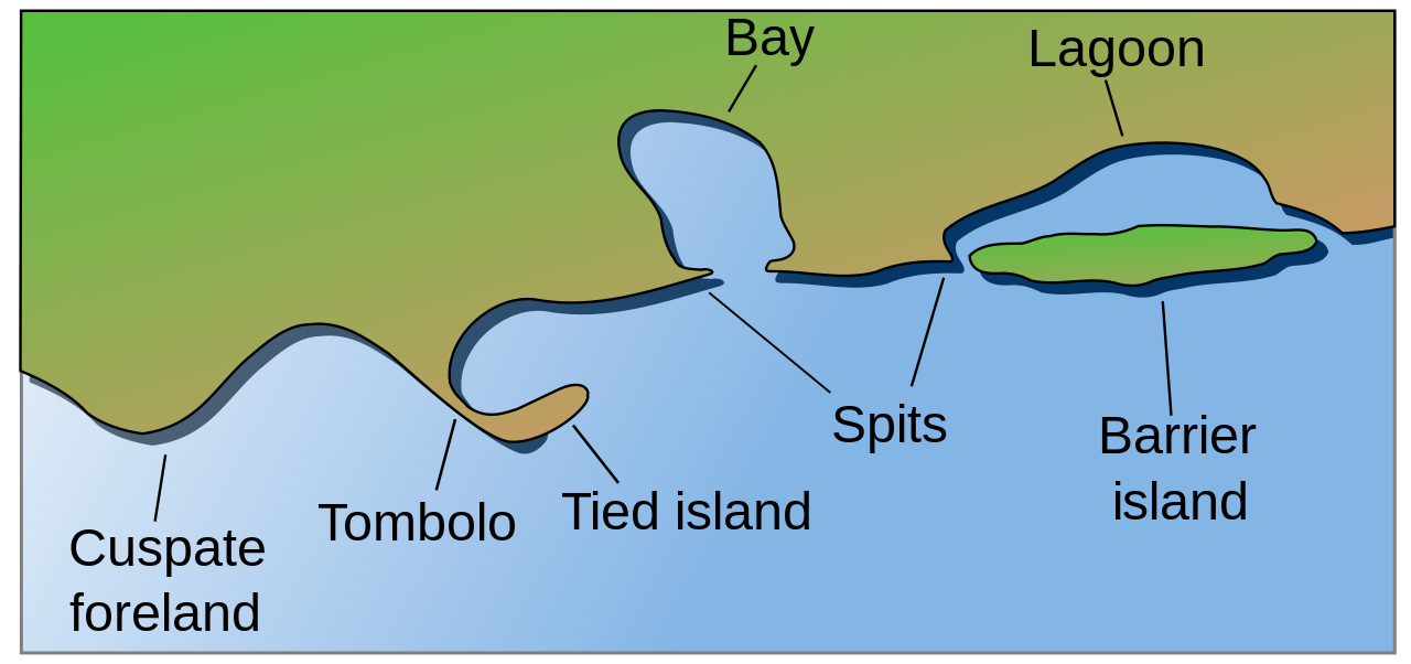
English: Coastal and oceanic landforms. Cuspate foreland, tombolo, spit, bay, lagoon, barrier island. |
| ದಿನಾಂಕ | |
| ಆಕರ | self-made SVG, based on the public domain PNG Accreting coast Image6.png by Feydey |
| ಕರ್ತೃ | Surachit |
| ಇತರೆ ಆವೃತ್ತಿಗಳು |
Derivative works of this file: Accreting coast Image6-ta.svg
|
| SVG genesis |


ಪರವಾನಗಿ
| This work has been released into the public domain by its author, Feydey. This applies worldwide. In some countries this may not be legally possible; if so: |
ಕಡತದ ಇತಿಹಾಸ
ದಿನ/ಕಾಲ ಒತ್ತಿದರೆ ಆ ಸಮಯದಲ್ಲಿ ಈ ಕಡತದ ವಸ್ತುಸ್ಥಿತಿ ತೋರುತ್ತದೆ.
| ದಿನ/ಕಾಲ | ಕಿರುನೋಟ | ಆಯಾಮಗಳು | ಬಳಕೆದಾರ | ಟಿಪ್ಪಣಿ | |
|---|---|---|---|---|---|
| ಪ್ರಸಕ್ತ | ೦೯:೪೭, ೧೬ ಮೇ ೨೦೨೨ | | ೧,೪೮೧ × ೬೯೭ (೧೫ KB) | Bacon Noodles | Fixed background (water) alignment |
| ೦೭:೧೯, ೧೨ ಫೆಬ್ರವರಿ ೨೦೧೮ |  | ೧,೪೮೧ × ೬೯೭ (೧೫ KB) | Howpper | Added tied island. A Tombolo is what connects a Tied island to the mainland, so it would be exclusive to not include both features. | |
| ೦೩:೧೮, ೧೭ ಆಗಸ್ಟ್ ೨೦೦೭ |  | ೧,೪೮೧ × ೬೯೭ (೧೩ KB) | Surachit | {{Information |Description=Coastal and oceanic landforms. Cuspate foreland, tombolo, spit, bay, lagoon, barrier island. |Source=self-made SVG, based on the public domain PNG [http://en.wikipedia.org/wiki/Image:Accreting_coast_Image6.png] by [http://en.wik |
ಕಡತ ಬಳಕೆ
ಈ ಕೆಳಗಿನ 3 ಪುಟಗಳು ಈ ಚಿತ್ರಕ್ಕೆ ಸಂಪರ್ಕ ಹೊಂದಿವೆ:
ಜಾಗತಿಕ ಕಡತ ಉಪಯೋಗ
ಈ ಕಡತವನ್ನು ಕೆಳಗಿನ ಬೇರೆ ವಿಕಿಗಳೂ ಉಪಯೋಗಿಸುತ್ತಿವೆ:
- ar.wikipedia.org ಮೇಲೆ ಬಳಕೆ
- az.wikipedia.org ಮೇಲೆ ಬಳಕೆ
- bh.wikipedia.org ಮೇಲೆ ಬಳಕೆ
- chr.wikipedia.org ಮೇಲೆ ಬಳಕೆ
- cs.wikipedia.org ಮೇಲೆ ಬಳಕೆ
- en.wikipedia.org ಮೇಲೆ ಬಳಕೆ
- Archipelago
- Coast
- Dune
- Island
- List of peninsulas
- Beach
- Fjord
- Atoll
- Strait
- Boulder
- Estuary
- Natural arch
- Lagoon
- Coral reef
- Firth
- Isthmus
- Gulf of California
- Coastal erosion
- Talk:Beach
- River delta
- Cliff
- Reef
- Islet
- Salt marsh
- Tombolo
- Stack (geology)
- Cove
- Shoal
- Spit (landform)
- Longshore drift
- Ria
- Barrier island
- Emergent coastline
- Submergent coastline
- Groyne
- Rip current
- Pebble
- Discordant coastline
- Wave-cut platform
ಈ ಫೈಲ್ನ ಹೆಚ್ಚು ಜಾಗತಿಕ ಬಳಕೆಯನ್ನು ವೀಕ್ಷಿಸಿ.