
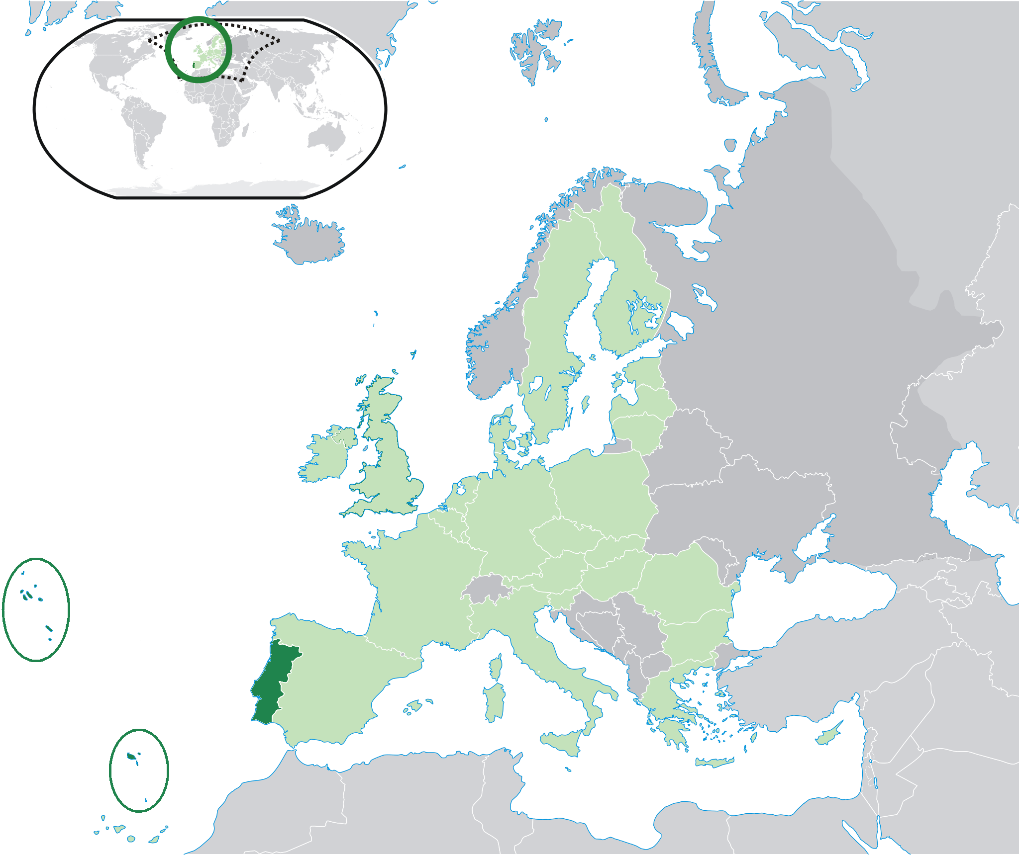
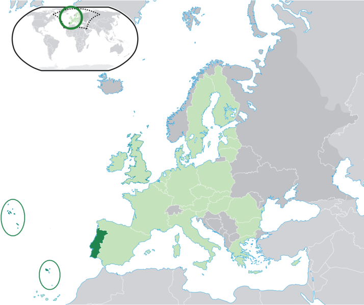
ಚಿತ್ರ:Location Portugal EU Europe.png
ಈ ಮುನ್ನೋಟ ಗಾತ್ರ:೭೧೪ × ೬೦೦ ಪಿಕ್ಸೆಲ್ಗಳು. ಇತರ ರೆಸಲ್ಯೂಶನ್ಗಳು: ೨೮೬ × ೨೪೦ ಪಿಕ್ಸೆಲ್ಗಳು | ೫೭೨ × ೪೮೦ ಪಿಕ್ಸೆಲ್ಗಳು | ೯೧೫ × ೭೬೮ ಪಿಕ್ಸೆಲ್ಗಳು | ೧,೨೧೯ × ೧,೦೨೪ ಪಿಕ್ಸೆಲ್ಗಳು | ೨,೦೪೮ × ೧,೭೨೦ ಪಿಕ್ಸೆಲ್ಗಳು.
ಮೂಲ ಕಡತ (೨,೦೪೮ × ೧,೭೨೦ ಚಿತ್ರಬಿಂದು, ಫೈಲಿನ ಗಾತ್ರ: ೨೩೯ KB, MIME ಪ್ರಕಾರ: image/png)
ಈ ಫೈಲು ವಿಕಿಮೀಡಿಯ ಕಾಮನ್ಸ್ನಲ್ಲಿ ಇರುವುದು. ಅಲ್ಲಿನ ವಿವರಣೆ ಪುಟವನ್ನೇ ಕೆಳಗೆ ತೋರಿಸಲಾಗಿದೆ. ಕಾಮನ್ಸ್ ಕೃತಿಸ್ವಾಮ್ಯತೆಯಿಂದ ಮುಕ್ತ ಫೈಲುಗಳ ಒಂದು ಆಗರ. ಅಲ್ಲಿ ನೀವೂ ಸಹಕರಿಸಬಹುದು. |

|
File:EU-Portugal with islands circled.svg is a vector version of this file. It should be used in place of this PNG file when not inferior.
File:Location Portugal EU Europe.png → File:EU-Portugal with islands circled.svg
For more information, see Help:SVG. |
 |
ಸಾರಾಂಶ
| ವಿವರ | Location map: Portugal (dark green) / European Union (light green) / Europe (dark grey); inspired by and consistent with general country locator maps by User:Vardion, et al. |
| ದಿನಾಂಕ | |
| ಆಕರ | ಸ್ವಂತ ಕೆಲಸ |
| ಕರ್ತೃ | Quizimodo |
| ಇತರೆ ಆವೃತ್ತಿಗಳು |
|


ಪರವಾನಗಿ
| This work has been released into the public domain by its author, I, Quizimodo. This applies worldwide. In some countries this may not be legally possible; if so: I, Quizimodo grants anyone the right to use this work for any purpose, without any conditions, unless such conditions are required by law. |
ಕಡತದ ಇತಿಹಾಸ
ದಿನ/ಕಾಲ ಒತ್ತಿದರೆ ಆ ಸಮಯದಲ್ಲಿ ಈ ಕಡತದ ವಸ್ತುಸ್ಥಿತಿ ತೋರುತ್ತದೆ.
| ದಿನ/ಕಾಲ | ಕಿರುನೋಟ | ಆಯಾಮಗಳು | ಬಳಕೆದಾರ | ಟಿಪ್ಪಣಿ | |
|---|---|---|---|---|---|
| ಪ್ರಸಕ್ತ | ೦೧:೧೭, ೨೭ ಜುಲೈ ೨೦೦೯ | | ೨,೦೪೮ × ೧,೭೨೦ (೨೩೯ KB) | The Ogre | Small correction |
| ೨೦:೦೭, ೨೪ ಜುಲೈ ೨೦೦೯ |  | ೨,೦೪೮ × ೧,೭೨೦ (೨೪೧ KB) | The Ogre | Still better visivility of islans (in agreement with the fact that the Savage islands ar a part of the Madeira archipelago) | |
| ೨೦:೦೦, ೨೪ ಜುಲೈ ೨೦೦೯ |  | ೨,೦೪೮ × ೧,೭೨೦ (೨೪೧ KB) | The Ogre | Better visibility of islands in the Atlantic | |
| ೧೯:೪೩, ೨೪ ಜುಲೈ ೨೦೦೯ |  | ೨,೦೪೮ × ೧,೭೨೦ (೨೪೦ KB) | The Ogre | Small corrections - included the islands of Corvo and Flores in the Azores, and the Desertas and Savage islands in Madeira. | |
| ೦೬:೩೬, ೧೮ ಜೂನ್ ೨೦೦೭ |  | ೨,೦೫೬ × ೧,೭೧೦ (೧೭೬ KB) | Quizimodo~commonswiki | image (updated) | |
| ೧೫:೪೩, ೧೭ ಜೂನ್ ೨೦೦೭ |  | ೨,೦೫೬ × ೧,೭೧೦ (೨೨೭ KB) | Quizimodo~commonswiki | image (tweaked) | |
| ೧೫:೩೬, ೧೭ ಜೂನ್ ೨೦೦೭ |  | ೨,೦೫೬ × ೧,೭೧೦ (೨೨೭ KB) | Quizimodo~commonswiki | image (tweaked) | |
| ೧೩:೨೩, ೧೭ ಜೂನ್ ೨೦೦೭ |  | ೨,೦೫೬ × ೧,೭೧೦ (೨೨೭ KB) | Quizimodo~commonswiki | image (tweaked) | |
| ೧೨:೪೮, ೧೭ ಜೂನ್ ೨೦೦೭ |  | ೨,೦೫೬ × ೧,೭೧೦ (೨೨೩ KB) | Quizimodo~commonswiki | image (tweaked) | |
| ೧೨:೧೫, ೧೭ ಜೂನ್ ೨೦೦೭ |  | ೨,೦೫೬ × ೧,೭೧೦ (೨೨೭ KB) | Quizimodo~commonswiki | {{Information |Description=Location map: Portugal (dark green) / European Union (light green) / Europe (dark grey); inspired by and consistent with general country locator maps by User:Vardion, et al |Source=self-made |Date= |Author= [[User:Quizimodo|Quiz |
ಕಡತ ಬಳಕೆ
ಈ ಕೆಳಗಿನ ಪುಟವು ಈ ಚಿತ್ರಕ್ಕೆ ಸಂಪರ್ಕ ಹೊಂದಿದೆ:
ಜಾಗತಿಕ ಕಡತ ಉಪಯೋಗ
ಈ ಕಡತವನ್ನು ಕೆಳಗಿನ ಬೇರೆ ವಿಕಿಗಳೂ ಉಪಯೋಗಿಸುತ್ತಿವೆ:
- bcl.wikipedia.org ಮೇಲೆ ಬಳಕೆ
- ceb.wikipedia.org ಮೇಲೆ ಬಳಕೆ
- de.wikinews.org ಮೇಲೆ ಬಳಕೆ
- dv.wikipedia.org ಮೇಲೆ ಬಳಕೆ
- dz.wikipedia.org ಮೇಲೆ ಬಳಕೆ
- es.wikipedia.org ಮೇಲೆ ಬಳಕೆ
- es.wikiquote.org ಮೇಲೆ ಬಳಕೆ
- eu.wiktionary.org ಮೇಲೆ ಬಳಕೆ
- fr.wikipedia.org ಮೇಲೆ ಬಳಕೆ
- gag.wikipedia.org ಮೇಲೆ ಬಳಕೆ
- got.wikipedia.org ಮೇಲೆ ಬಳಕೆ
- gu.wikipedia.org ಮೇಲೆ ಬಳಕೆ
- ka.wikipedia.org ಮೇಲೆ ಬಳಕೆ
- ku.wiktionary.org ಮೇಲೆ ಬಳಕೆ
- no.wikipedia.org ಮೇಲೆ ಬಳಕೆ
- pl.wiktionary.org ಮೇಲೆ ಬಳಕೆ
- pt.wikinews.org ಮೇಲೆ ಬಳಕೆ
- ro.wikipedia.org ಮೇಲೆ ಬಳಕೆ
- ro.wikibooks.org ಮೇಲೆ ಬಳಕೆ
- te.wikipedia.org ಮೇಲೆ ಬಳಕೆ
- ug.wikipedia.org ಮೇಲೆ ಬಳಕೆ
- zh-classical.wikipedia.org ಮೇಲೆ ಬಳಕೆ