
ಚಿತ್ರ:South Africa Free State relief location map.svg

Size of this PNG preview of this SVG file: ೬೭೨ × ೫೯೯ ಪಿಕ್ಸೆಲ್ಗಳು. ಇತರ ರೆಸಲ್ಯೂಶನ್ಗಳು: ೨೬೯ × ೨೪೦ ಪಿಕ್ಸೆಲ್ಗಳು | ೫೩೮ × ೪೮೦ ಪಿಕ್ಸೆಲ್ಗಳು | ೮೬೧ × ೭೬೮ ಪಿಕ್ಸೆಲ್ಗಳು | ೧,೧೪೮ × ೧,೦೨೪ ಪಿಕ್ಸೆಲ್ಗಳು | ೨,೨೯೬ × ೨,೦೪೮ ಪಿಕ್ಸೆಲ್ಗಳು | ೧,೧೩೦ × ೧,೦೦೮ ಪಿಕ್ಸೆಲ್ಗಳು.
ಮೂಲ ಕಡತ (SVG ಫೈಲು, ಸುಮಾರಾಗಿ ೧,೧೩೦ × ೧,೦೦೮ ಚಿತ್ರಬಿಂದುಗಳು, ಫೈಲಿನ ಗಾತ್ರ: ೨.೨೪ MB)
ಈ ಫೈಲು ವಿಕಿಮೀಡಿಯ ಕಾಮನ್ಸ್ನಲ್ಲಿ ಇರುವುದು. ಅಲ್ಲಿನ ವಿವರಣೆ ಪುಟವನ್ನೇ ಕೆಳಗೆ ತೋರಿಸಲಾಗಿದೆ. ಕಾಮನ್ಸ್ ಕೃತಿಸ್ವಾಮ್ಯತೆಯಿಂದ ಮುಕ್ತ ಫೈಲುಗಳ ಒಂದು ಆಗರ. ಅಲ್ಲಿ ನೀವೂ ಸಹಕರಿಸಬಹುದು. |
| ವಿವರ |
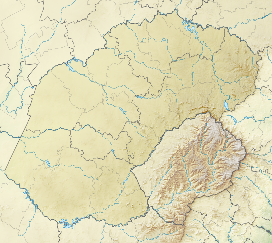
English: Relief location map of the Free State
Equirectangular projection, N/S stretching 114%. Geographic limits of the map:
|
| ದಿನಾಂಕ | |
| ಆಕರ | |
| ಕರ್ತೃ | Htonl |
| ಅನುಮತಿ (ಈ ಕಡತವನ್ನು ಮರುಬಳಕೆ ಮಾಡಲಾಗುತ್ತಿದೆ) |
I, the copyright holder of this work, hereby publish it under the following license: ಈ ಕಡತ ಕ್ರಿಯೇಟಿವ್ ಕಾಮನ್ಸ್ Attribution
-Share Alike 3.0 Unported ಪರವಾನಗಿ ಹೊಂದಿದೆ.
|
| ಇತರೆ ಆವೃತ್ತಿಗಳು | File:South Africa Free State location map.svg |
ಕಡತದ ಇತಿಹಾಸ
ದಿನ/ಕಾಲ ಒತ್ತಿದರೆ ಆ ಸಮಯದಲ್ಲಿ ಈ ಕಡತದ ವಸ್ತುಸ್ಥಿತಿ ತೋರುತ್ತದೆ.
| ದಿನ/ಕಾಲ | ಕಿರುನೋಟ | ಆಯಾಮಗಳು | ಬಳಕೆದಾರ | ಟಿಪ್ಪಣಿ | |
|---|---|---|---|---|---|
| ಪ್ರಸಕ್ತ | ೦೫:೨೮, ೬ ಜನವರಿ ೨೦೧೩ | | ೧,೧೩೦ × ೧,೦೦೮ (೨.೨೪ MB) | Htonl | {{Information |Description ={{en|1=Relief location map of the Free State Equirectangular projection, N/S stretching 114%. Geographic limits of the map: * N: 26.5° S * S: 31° S * W: 24.25° E * E: 30° E}} |Source ... |
ಕಡತ ಬಳಕೆ
ಈ ಕೆಳಗಿನ ಪುಟವು ಈ ಚಿತ್ರಕ್ಕೆ ಸಂಪರ್ಕ ಹೊಂದಿದೆ:
ಜಾಗತಿಕ ಕಡತ ಉಪಯೋಗ
ಈ ಕಡತವನ್ನು ಕೆಳಗಿನ ಬೇರೆ ವಿಕಿಗಳೂ ಉಪಯೋಗಿಸುತ್ತಿವೆ:
- ar.wikipedia.org ಮೇಲೆ ಬಳಕೆ
- bg.wikipedia.org ಮೇಲೆ ಬಳಕೆ
- ceb.wikipedia.org ಮೇಲೆ ಬಳಕೆ
- de.wikipedia.org ಮೇಲೆ ಬಳಕೆ
- en.wikipedia.org ಮೇಲೆ ಬಳಕೆ
- Phuthaditjhaba
- 1 Special Service Battalion
- Golden Gate Highlands National Park
- Caledon Nature Reserve
- Sandveld Nature Reserve
- Koppies Dam Nature Reserve
- Koppies Dam
- Module:Location map/data/South Africa Free State/doc
- Willem Pretorius Game Reserve
- Kroonstad Airport
- Module:Location map/data/South Africa Free State
- Schoeman Park Open
- 2022 Jagersfontein dam collapse
- eo.wikipedia.org ಮೇಲೆ ಬಳಕೆ
- es.wikipedia.org ಮೇಲೆ ಬಳಕೆ
- frr.wikipedia.org ಮೇಲೆ ಬಳಕೆ
- fr.wikipedia.org ಮೇಲೆ ಬಳಕೆ
- he.wikipedia.org ಮೇಲೆ ಬಳಕೆ
- ja.wikipedia.org ಮೇಲೆ ಬಳಕೆ
- lv.wikipedia.org ಮೇಲೆ ಬಳಕೆ
- os.wikipedia.org ಮೇಲೆ ಬಳಕೆ
- pl.wikipedia.org ಮೇಲೆ ಬಳಕೆ
- pl.wikibooks.org ಮೇಲೆ ಬಳಕೆ
- ru.wikipedia.org ಮೇಲೆ ಬಳಕೆ
- si.wikipedia.org ಮೇಲೆ ಬಳಕೆ
ಈ ಫೈಲ್ನ ಹೆಚ್ಚು ಜಾಗತಿಕ ಬಳಕೆಯನ್ನು ವೀಕ್ಷಿಸಿ.