
ಚಿತ್ರ:South Africa Eastern Cape relief location map.svg

Size of this PNG preview of this SVG file: ೮೦೦ × ೫೫೬ ಪಿಕ್ಸೆಲ್ಗಳು. ಇತರ ರೆಸಲ್ಯೂಶನ್ಗಳು: ೩೨೦ × ೨೨೨ ಪಿಕ್ಸೆಲ್ಗಳು | ೬೪೦ × ೪೪೫ ಪಿಕ್ಸೆಲ್ಗಳು | ೧,೦೨೪ × ೭೧೨ ಪಿಕ್ಸೆಲ್ಗಳು | ೧,೨೮೦ × ೮೮೯ ಪಿಕ್ಸೆಲ್ಗಳು | ೨,೫೬೦ × ೧,೭೭೯ ಪಿಕ್ಸೆಲ್ಗಳು | ೧,೨೯೮ × ೯೦೨ ಪಿಕ್ಸೆಲ್ಗಳು.
ಮೂಲ ಕಡತ (SVG ಫೈಲು, ಸುಮಾರಾಗಿ ೧,೨೯೮ × ೯೦೨ ಚಿತ್ರಬಿಂದುಗಳು, ಫೈಲಿನ ಗಾತ್ರ: ೨.೨೯ MB)
ಈ ಫೈಲು ವಿಕಿಮೀಡಿಯ ಕಾಮನ್ಸ್ನಲ್ಲಿ ಇರುವುದು. ಅಲ್ಲಿನ ವಿವರಣೆ ಪುಟವನ್ನೇ ಕೆಳಗೆ ತೋರಿಸಲಾಗಿದೆ. ಕಾಮನ್ಸ್ ಕೃತಿಸ್ವಾಮ್ಯತೆಯಿಂದ ಮುಕ್ತ ಫೈಲುಗಳ ಒಂದು ಆಗರ. ಅಲ್ಲಿ ನೀವೂ ಸಹಕರಿಸಬಹುದು. |
| ವಿವರ |
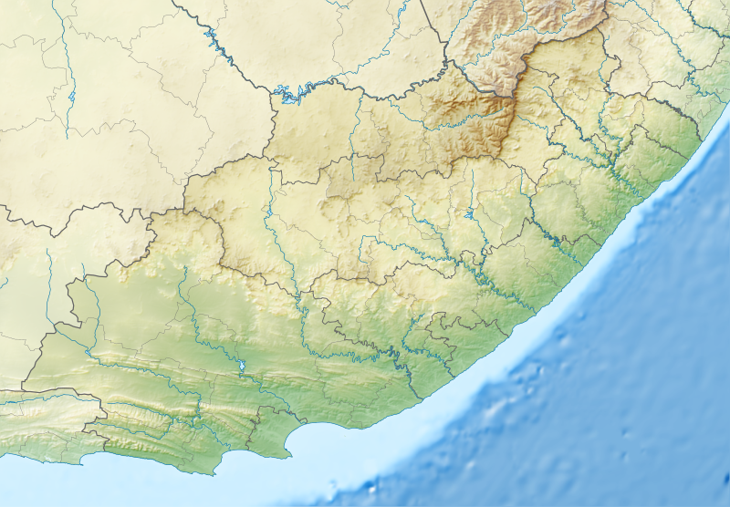
English: Relief location map of the Eastern Cape
Equirectangular projection, N/S stretching 117%. Geographic limits of the map:
|
| ದಿನಾಂಕ | |
| ಆಕರ |
|
| ಕರ್ತೃ | Htonl |
| ಅನುಮತಿ (ಈ ಕಡತವನ್ನು ಮರುಬಳಕೆ ಮಾಡಲಾಗುತ್ತಿದೆ) |
I, the copyright holder of this work, hereby publish it under the following license: ಈ ಕಡತ ಕ್ರಿಯೇಟಿವ್ ಕಾಮನ್ಸ್ Attribution
-Share Alike 3.0 Unported ಪರವಾನಗಿ ಹೊಂದಿದೆ.
|
| ಇತರೆ ಆವೃತ್ತಿಗಳು | File:South Africa Eastern Cape location map.svg |
ಕಡತದ ಇತಿಹಾಸ
ದಿನ/ಕಾಲ ಒತ್ತಿದರೆ ಆ ಸಮಯದಲ್ಲಿ ಈ ಕಡತದ ವಸ್ತುಸ್ಥಿತಿ ತೋರುತ್ತದೆ.
| ದಿನ/ಕಾಲ | ಕಿರುನೋಟ | ಆಯಾಮಗಳು | ಬಳಕೆದಾರ | ಟಿಪ್ಪಣಿ | |
|---|---|---|---|---|---|
| ಪ್ರಸಕ್ತ | ೦೩:೩೫, ೫ ಜನವರಿ ೨೦೧೩ | | ೧,೨೯೮ × ೯೦೨ (೨.೨೯ MB) | Htonl | Fix Lesotho masking |
| ೦೩:೧೮, ೫ ಜನವರಿ ೨೦೧೩ |  | ೧,೨೯೮ × ೯೦೨ (೨.೨೯ MB) | Htonl | {{Information |Description ={{en|1=Relief location map of the Eastern Cape Equirectangular projection, N/S stretching 117%. Geographic limits of the map: * N: 29.75° S * S: 34.5° S * W: 22.5° E * E: 30.5° E}} |Source ... |
ಕಡತ ಬಳಕೆ
ಈ ಕೆಳಗಿನ ಪುಟವು ಈ ಚಿತ್ರಕ್ಕೆ ಸಂಪರ್ಕ ಹೊಂದಿದೆ:
ಜಾಗತಿಕ ಕಡತ ಉಪಯೋಗ
ಈ ಕಡತವನ್ನು ಕೆಳಗಿನ ಬೇರೆ ವಿಕಿಗಳೂ ಉಪಯೋಗಿಸುತ್ತಿವೆ:
- af.wikipedia.org ಮೇಲೆ ಬಳಕೆ
- ar.wikipedia.org ಮೇಲೆ ಬಳಕೆ
- ban.wikipedia.org ಮೇಲೆ ಬಳಕೆ
- bg.wikipedia.org ಮೇಲೆ ಬಳಕೆ
- bn.wikipedia.org ಮೇಲೆ ಬಳಕೆ
- ceb.wikipedia.org ಮೇಲೆ ಬಳಕೆ
- de.wikipedia.org ಮೇಲೆ ಬಳಕೆ
- en.wikipedia.org ಮೇಲೆ ಬಳಕೆ
- King Phalo Airport
- Chief Dawid Stuurman International Airport
- MTS Oceanos
- Ben Macdhui (Eastern Cape)
- Mountain Zebra National Park
- Mthatha
- Nahoon River
- South African PGA Championship
- Shamwari Game Reserve
- Port Alfred Airport
- Inkwenkwezi Private Game Reserve
- User:Xhantar/Sandbox2
- Mthatha Airport
- Doddington (East Indiaman)
- Kouga Dam
- Orange–Fish River Tunnel
- South African Masters
- Africa Open
- Great Fish River Nature Reserve
- Baviaanskloof Mega Reserve
- Commando Drift Nature Reserve
- East London Coast Nature Reserve
- Hluleka Nature Reserve
- Mpofu Nature Reserve
ಈ ಫೈಲ್ನ ಹೆಚ್ಚು ಜಾಗತಿಕ ಬಳಕೆಯನ್ನು ವೀಕ್ಷಿಸಿ.