
ಚಿತ್ರ:Rajendra territories cl.png
Rajendra_territories_cl.png (೬೫೦ × ೪೬೪ ಚಿತ್ರಬಿಂದು, ಫೈಲಿನ ಗಾತ್ರ: ೫೦೪ KB, MIME ಪ್ರಕಾರ: image/png)
ಈ ಫೈಲು ವಿಕಿಮೀಡಿಯ ಕಾಮನ್ಸ್ನಲ್ಲಿ ಇರುವುದು. ಅಲ್ಲಿನ ವಿವರಣೆ ಪುಟವನ್ನೇ ಕೆಳಗೆ ತೋರಿಸಲಾಗಿದೆ. ಕಾಮನ್ಸ್ ಕೃತಿಸ್ವಾಮ್ಯತೆಯಿಂದ ಮುಕ್ತ ಫೈಲುಗಳ ಒಂದು ಆಗರ. ಅಲ್ಲಿ ನೀವೂ ಸಹಕರಿಸಬಹುದು. |

ಸಾರಾಂಶ
| ವಿವರ |
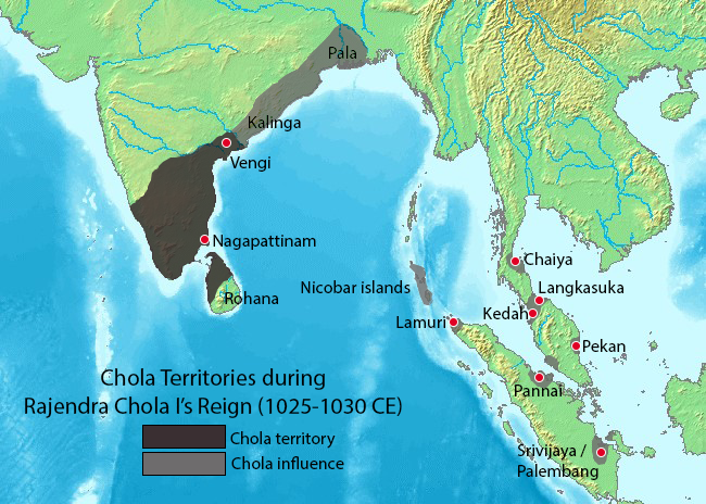
Map showing the extent of the Chola empire during Rajendra Chola I. Source of map: http://www2.demis.nl/mapserver/mapper.asp (mention : "Disclaimer: With this statement DEMIS BV grants you permission to freely copy the PNG images returned by our server and use them for your own purposes, including web pages. We would appreciate a reference to our server but such a reference is not required, nor do we take responsibility for the accuracy or quality of the maps". at http://www2.demis.nl/mapserver/DataSrc.htm) Modified by myself using Adobe Photoshop. Note: This file was imported to Commons by Nicke L on 25 June 2006, then updated based on https://commons.wikimedia.org/wiki/File:Rajendra_map_new.svg and https://en.wikipedia.org/wiki/Talk:Chola_dynasty#Maps by Verosaurus on 27 December 2022. Pegu isn't included in the influence area since the original map did not include that city. |
||||||||
| ಆಕರ | Source of map: http://www2.demis.nl/mapserver/mapper.asp | ||||||||
| ಕರ್ತೃ | User Venu62 on en.wikipedia | ||||||||
| ಅನುಮತಿ (ಈ ಕಡತವನ್ನು ಮರುಬಳಕೆ ಮಾಡಲಾಗುತ್ತಿದೆ) |
Venu62 from en.wikipedia.org, the copyright holder of this work, hereby publishes it under the following license:
|
||||||||
| ಇತರೆ ಆವೃತ್ತಿಗಳು |
Originally from en.wikipedia; description page is (was) here
|

ಕಡತದ ಇತಿಹಾಸ
ದಿನ/ಕಾಲ ಒತ್ತಿದರೆ ಆ ಸಮಯದಲ್ಲಿ ಈ ಕಡತದ ವಸ್ತುಸ್ಥಿತಿ ತೋರುತ್ತದೆ.
| ದಿನ/ಕಾಲ | ಕಿರುನೋಟ | ಆಯಾಮಗಳು | ಬಳಕೆದಾರ | ಟಿಪ್ಪಣಿ | |
|---|---|---|---|---|---|
| ಪ್ರಸಕ್ತ | ೦೩:೧೪, ೨೮ ಡಿಸೆಂಬರ್ ೨೦೨೨ | | ೬೫೦ × ೪೬೪ (೫೦೪ KB) | Verosaurus | Revised based on https://commons.wikimedia.org/wiki/File:Rajendra_map_new.svg and https://en.wikipedia.org/wiki/Talk:Chola_dynasty#Maps . Pegu isn't included since it's not on the original map, furthermore, it isn't mentioned in the Tanjore inscription. |
| ೧೯:೧೦, ೨೫ ಜೂನ್ ೨೦೦೬ |  | ೪೮೨ × ೪೩೦ (೧೧೯ KB) | Nicke L | {{Information| |Description= == Summary == Map showing the extent of the Chola empire during Rajendra Chola I. Source of map: http://www2.demis.nl/mapserver/mapper.asp (mention : "Disclaimer: With this statement DEMIS BV grants you permission to freely c |
ಕಡತ ಬಳಕೆ
ಈ ಫೈಲನ್ನು ಬಳಸುವ ಯಾವ ಪುಟಗಳೂ ಇಲ್ಲ.
ಜಾಗತಿಕ ಕಡತ ಉಪಯೋಗ
ಈ ಕಡತವನ್ನು ಕೆಳಗಿನ ಬೇರೆ ವಿಕಿಗಳೂ ಉಪಯೋಗಿಸುತ್ತಿವೆ:
- ast.wikipedia.org ಮೇಲೆ ಬಳಕೆ
- en.wikipedia.org ಮೇಲೆ ಬಳಕೆ
- es.wikipedia.org ಮೇಲೆ ಬಳಕೆ
- fr.wikipedia.org ಮೇಲೆ ಬಳಕೆ
- ko.wikipedia.org ಮೇಲೆ ಬಳಕೆ
- lt.wikipedia.org ಮೇಲೆ ಬಳಕೆ
- nl.wikipedia.org ಮೇಲೆ ಬಳಕೆ
- sq.wikipedia.org ಮೇಲೆ ಬಳಕೆ
- sv.wikipedia.org ಮೇಲೆ ಬಳಕೆ
- ta.wikipedia.org ಮೇಲೆ ಬಳಕೆ
- zh-yue.wikipedia.org ಮೇಲೆ ಬಳಕೆ
- zh.wikipedia.org ಮೇಲೆ ಬಳಕೆ