
ಚಿತ್ರ:Plan Centre Spatial Guyanais-en.svg

Size of this PNG preview of this SVG file: ೬೪೮ × ೫೯೯ ಪಿಕ್ಸೆಲ್ಗಳು. ಇತರ ರೆಸಲ್ಯೂಶನ್ಗಳು: ೨೬೦ × ೨೪೦ ಪಿಕ್ಸೆಲ್ಗಳು | ೫೧೯ × ೪೮೦ ಪಿಕ್ಸೆಲ್ಗಳು | ೮೩೧ × ೭೬೮ ಪಿಕ್ಸೆಲ್ಗಳು | ೧,೧೦೮ × ೧,೦೨೪ ಪಿಕ್ಸೆಲ್ಗಳು | ೨,೨೧೫ × ೨,೦೪೮ ಪಿಕ್ಸೆಲ್ಗಳು | ೧,೦೬೦ × ೯೮೦ ಪಿಕ್ಸೆಲ್ಗಳು.
ಮೂಲ ಕಡತ (SVG ಫೈಲು, ಸುಮಾರಾಗಿ ೧,೦೬೦ × ೯೮೦ ಚಿತ್ರಬಿಂದುಗಳು, ಫೈಲಿನ ಗಾತ್ರ: ೪೭೨ KB)
ಈ ಫೈಲು ವಿಕಿಮೀಡಿಯ ಕಾಮನ್ಸ್ನಲ್ಲಿ ಇರುವುದು. ಅಲ್ಲಿನ ವಿವರಣೆ ಪುಟವನ್ನೇ ಕೆಳಗೆ ತೋರಿಸಲಾಗಿದೆ. ಕಾಮನ್ಸ್ ಕೃತಿಸ್ವಾಮ್ಯತೆಯಿಂದ ಮುಕ್ತ ಫೈಲುಗಳ ಒಂದು ಆಗರ. ಅಲ್ಲಿ ನೀವೂ ಸಹಕರಿಸಬಹುದು. |

|
This SVG file contains embedded text that can be translated into your language, using any capable SVG editor, text editor or the SVG Translate tool. For more information see: About translating SVG files. |
ಸಾರಾಂಶ
| ವಿವರ |
[]
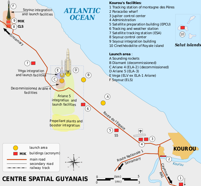
Català: Mapa de la infraestructura dels llançadors Ariane i Vega al port espacial europeu (Centre Spatial Guyanais o CSG), Kourou, Guaiana Francesa Deutsch: Karte der Infrastruktur der Ariana- und Vega-Startrampen auf dem Weltraumbahnhof Kourou, Französisch-Guayana English: Map of the infrastructure for the Ariane and Vega launchers at the Europe's Spaceport (Centre Spatial Guyanais or CSG) , Kourou, French Guiana Français : Carte des installations du Centre Spatial Guyanais (CSG) de Kourou, Guyane Francaise (France) Magyar: A Guyanai Űrközpont térképe Nederlands: Kaart van de Europese lanceerbasis (Centre Spatial Guyanais of CSG) in Kourou, Frans Guiana Русский: План космодрома «Куру» во Французской Гвиане |
||
| ದಿನಾಂಕ | |||
| ಆಕರ | ಸ್ವಂತ ಕೆಲಸ | ||
| ಕರ್ತೃ | Pline | ||
| ಇತರೆ ಆವೃತ್ತಿಗಳು |
[]
|


ಪರವಾನಗಿ
I, the copyright holder of this work, hereby publish it under the following licenses:

|
GNU ಉಚಿತ ಡಾಕ್ಯುಮೆಂಟೇಶನ್ ಪರವಾನಗಿ, ಆವೃತ್ತಿಯ ನಿಯಮಗಳ ಅಡಿಯಲ್ಲಿ ಈ ಡಾಕ್ಯುಮೆಂಟ್ ಅನ್ನು ನಕಲಿಸಲು, ವಿತರಿಸಲು ಮತ್ತು/ಅಥವಾ ಮಾರ್ಪಡಿಸಲು ಅನುಮತಿಯನ್ನು ನೀಡಲಾಗಿದೆ. 1.2 ಅಥವಾ ಯಾವುದೇ ನಂತರದ ಆವೃತ್ತಿಯನ್ನು ಉಚಿತ ಸಾಫ್ಟ್ವೇರ್ ಫೌಂಡೇಶನ್ ಪ್ರಕಟಿಸಿದೆ; ಯಾವುದೇ ಅಸ್ಥಿರ ವಿಭಾಗಗಳಿಲ್ಲದೆ, ಮುಖ ಪಠ್ಯಗಳಿಲ್ಲ ಮತ್ತು ಹಿಂದಿನ ಕವರ್ ಪಠ್ಯಗಳಿಲ್ಲ. ಪರವಾನಗಿಯ ಪ್ರತಿಯನ್ನು GNU ಉಚಿತ ಡಾಕ್ಯುಮೆಂಟೇಶನ್ ಪರವಾನಗಿ ಎಂಬ ವಿಭಾಗದಲ್ಲಿ ಸೇರಿಸಲಾಗಿದೆ. |
This file is licensed under the Creative Commons Attribution-Share Alike 3.0 Unported, 2.5 Generic, 2.0 Generic and 1.0 Generic license.
- ನೀವು ಮುಕ್ತ:
- ಹಂಚಿಕೆಗೆ – ಕೆಲಸವನ್ನು ನಕಲು ಮಾಡಲು, ವಿತರಣೆ ಮತ್ತು ಸಾಗಿಸಲು
- ರೀಮಿಕ್ಸ್ ಮಾಡಲು – ಕೆಲಸವನ್ನು ಬಳಸಿಕೊಳ್ಳಲು
- ಈ ಕೆಳಗಿನ ಷರತ್ತುಗಳಲ್ಲಿ:
- ವೈಶಿಷ್ಟ್ಯ – ನೀವು ಸೂಕ್ತವಾದ ಕ್ರೆಡಿಟ್ ನೀಡಬೇಕು, ಪರವಾನಗಿಗೆ ಲಿಂಕ್ ಅನ್ನು ಒದಗಿಸಬೇಕು ಮತ್ತು ಯಾವುದೇ ಬದಲಾವಣೆಗಳನ್ನು ಮಾಡಿದ್ದರೆ ಸೂಚಿಸಬೇಕು. ನೀವು ಯಾವುದೇ ಸಮಂಜಸವಾದ ರೀತಿಯಲ್ಲಿ ಮಾಡಬಹುದು, ಆದರೆ ಪರವಾನಗಿದಾರರು ನಿಮ್ಮನ್ನು ಅಥವಾ ನಿಮ್ಮ ಯಾವುದೇ ಬಳಕೆಯನ್ನು ಅನುಮೋದಿಸಿದಂತೆ ರೀತಿಯಲ್ಲಿ ಉಪಯೋಗಿಸಬಾರದು.
- ಇರುವುದರಂತೆಯೇ ಹಂಚು – ನೀವು ರೀಮಿಕ್ಸ್ ಮಾಡಿದರೆ, ರೂಪಾಂತರಗೊಳಿಸಿದರೆ ಅಥವಾ ವಸ್ತುವಿನ ಮೇಲೆ ನಿರ್ಮಿಸಿದರೆ, ನಿಮ್ಮ ಕೊಡುಗೆಗಳನ್ನು ನೀವು ಮೂಲದಂತೆ ಅದೇ ಅಥವಾ ಹೊಂದಾಣಿಕೆಯ ಪರವಾನಗಿ ಅಡಿಯಲ್ಲಿ ವಿತರಿಸಬೇಕು.
ನಿಮ್ಮಿಚ್ಛೆಯ ಪರವಾನಗಿಯನ್ನು ನೀವು ಆರಿಸಿಕೊಳ್ಳಬಹುದು.
ಕಡತದ ಇತಿಹಾಸ
ದಿನ/ಕಾಲ ಒತ್ತಿದರೆ ಆ ಸಮಯದಲ್ಲಿ ಈ ಕಡತದ ವಸ್ತುಸ್ಥಿತಿ ತೋರುತ್ತದೆ.
| ದಿನ/ಕಾಲ | ಕಿರುನೋಟ | ಆಯಾಮಗಳು | ಬಳಕೆದಾರ | ಟಿಪ್ಪಣಿ | |
|---|---|---|---|---|---|
| ಪ್ರಸಕ್ತ | ೨೩:೩೮, ೪ ಮಾರ್ಚ್ ೨೦೧೬ | | ೧,೦೬೦ × ೯೮೦ (೪೭೨ KB) | Manlleus | Sorry again! |
| ೨೩:೩೬, ೪ ಮಾರ್ಚ್ ೨೦೧೬ |  | ೧,೦೬೦ × ೯೮೦ (೫೨೪ KB) | Manlleus | Reverted to version as of 13:37, 13 April 2009 (UTC) - Sorry, was a big error! | |
| ೦೨:೨೧, ೨ ಫೆಬ್ರವರಿ ೨೦೧೬ |  | ೧,೦೬೦ × ೯೮೦ (೫೨೪ KB) | Manlleus | Editing SVG source code using User:Rillke/SVGedit.js; upload handled by User:Rillke/MwJSBot.js | |
| ೧೯:೦೭, ೧೩ ಏಪ್ರಿಲ್ ೨೦೦೯ |  | ೧,೦೬೦ × ೯೮೦ (೫೨೪ KB) | Pline | {{Information |Description={{en|1=Map of the infrastructure for the Ariane and Vega launchers at the Europe's Spaceport (Centre Spatial Guyanais or CSG) , Kourou, French Guiana}} {{fr|1=Carte des installations du Centre Spatial Guyanais (CSG) de Kourou, G |
ಕಡತ ಬಳಕೆ
ಈ ಕೆಳಗಿನ ಪುಟವು ಈ ಚಿತ್ರಕ್ಕೆ ಸಂಪರ್ಕ ಹೊಂದಿದೆ:
ಜಾಗತಿಕ ಕಡತ ಉಪಯೋಗ
ಈ ಕಡತವನ್ನು ಕೆಳಗಿನ ಬೇರೆ ವಿಕಿಗಳೂ ಉಪಯೋಗಿಸುತ್ತಿವೆ:
- el.wikipedia.org ಮೇಲೆ ಬಳಕೆ
- en.wikipedia.org ಮೇಲೆ ಬಳಕೆ
- eo.wikipedia.org ಮೇಲೆ ಬಳಕೆ
- es.wikipedia.org ಮೇಲೆ ಬಳಕೆ
- et.wikipedia.org ಮೇಲೆ ಬಳಕೆ
- fi.wikipedia.org ಮೇಲೆ ಬಳಕೆ
- he.wikipedia.org ಮೇಲೆ ಬಳಕೆ
- id.wikipedia.org ಮೇಲೆ ಬಳಕೆ
- it.wikipedia.org ಮೇಲೆ ಬಳಕೆ
- ja.wikipedia.org ಮೇಲೆ ಬಳಕೆ
- lv.wikipedia.org ಮೇಲೆ ಬಳಕೆ
- ms.wikipedia.org ಮೇಲೆ ಬಳಕೆ
- no.wikipedia.org ಮೇಲೆ ಬಳಕೆ
- ro.wikipedia.org ಮೇಲೆ ಬಳಕೆ
- sk.wikipedia.org ಮೇಲೆ ಬಳಕೆ
- sl.wikipedia.org ಮೇಲೆ ಬಳಕೆ
- sr.wikipedia.org ಮೇಲೆ ಬಳಕೆ
- uk.wikipedia.org ಮೇಲೆ ಬಳಕೆ
- vi.wikipedia.org ಮೇಲೆ ಬಳಕೆ
- zh.wikipedia.org ಮೇಲೆ ಬಳಕೆ