
ಚಿತ್ರ:National Atlas Louisiana closeup ESE.gif
ಇದಕ್ಕಿಂತ ಹೆಚ್ಚಿನ ವಿವರವಾದ ನೋಟ ಇಲ್ಲ.
National_Atlas_Louisiana_closeup_ESE.gif (೨೪೫ × ೩೦೦ ಚಿತ್ರಬಿಂದು, ಫೈಲಿನ ಗಾತ್ರ: ೨೮ KB, MIME ಪ್ರಕಾರ: image/gif)
ಈ ಫೈಲು ವಿಕಿಮೀಡಿಯ ಕಾಮನ್ಸ್ನಲ್ಲಿ ಇರುವುದು. ಅಲ್ಲಿನ ವಿವರಣೆ ಪುಟವನ್ನೇ ಕೆಳಗೆ ತೋರಿಸಲಾಗಿದೆ. ಕಾಮನ್ಸ್ ಕೃತಿಸ್ವಾಮ್ಯತೆಯಿಂದ ಮುಕ್ತ ಫೈಲುಗಳ ಒಂದು ಆಗರ. ಅಲ್ಲಿ ನೀವೂ ಸಹಕರಿಸಬಹುದು. |
ಸಾರಾಂಶ
| ವಿವರ |
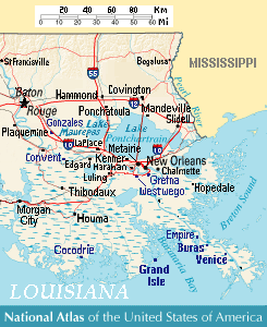
Close view of east-southeast Louisiana (USA), showing areas of Baton Rouge, New Orleans, Metairie, Chalmette, Gretna, Westwego, Harahan, Luling, Kenner, LaPlace, Edgard, Convent, Slidell, Mandeville, Covington, Ponchatoula, Houma, Cocodrie, Buras, Venice, and Grand Isle, Louisiana. Lakes include: Lake Pontchartrain, Lake Maurepas (west), and Lake Salvador (south of Pontchartrain). |
| ದಿನಾಂಕ | 27-June-2007 (re-uploaded 10-September-2007) |
| ಆಕರ | Except from National Atlas of the United States, with more towns labeled/clarified from reference road map. |
| ಕರ್ತೃ | User:Wikid77 (derived from National Atlas) |
References
- Louisiana-Map.org, webpage: LaMap-Louisiana-road-map (shows town/lake names).
- Transwiki from Wikipedia:en approved by: w:en:User:Dmcdevit
ಪರವಾನಗಿ
This map was obtained from an edition of the National Atlas of the United States. Like almost all works of the U.S. federal government, works from the National Atlas are in the public domain in the United States.
Online access: NationalAtlas.gov | 1970 print edition: Library of Congress, Perry-Castañeda Library
|
Image description page history
| link | date/time | username | edit summary |
|---|---|---|---|
| (n/a) | 07:42, 10 September 2007 | w:en:User:Dmcdevit | |
| (n/a) | 06:31, 5 July 2007 | w:en:User:Wikid77 | |
| (n/a) | 06:23, 5 July 2007 | w:en:User:Wikid77 | |
| (n/a) | 22:20, 4 July 2007 | w:en:User:Wikid77 | |
| (n/a) | 21:45, 4 July 2007 | w:en:User:Wikid77 | |
| (n/a) | 19:00, 1 July 2007 | w:en:User:Wikid77 | |
| (n/a) | 12:41, 28 June 2007 | w:en:User:Wikid77 | |
| (n/a) | 12:35, 28 June 2007 | w:en:User:Wikid77 | |
| (n/a) | 05:35, 28 June 2007 | w:en:User:Wikid77 | |
| (n/a) | 22:32, 27 June 2007 | w:en:User:Wikid77 | |
| (n/a) | 11:13, 27 June 2007 | w:en:User:Wikid77 | (created on Wikipedia:en) |
ಕಡತದ ಇತಿಹಾಸ
ದಿನ/ಕಾಲ ಒತ್ತಿದರೆ ಆ ಸಮಯದಲ್ಲಿ ಈ ಕಡತದ ವಸ್ತುಸ್ಥಿತಿ ತೋರುತ್ತದೆ.
| ದಿನ/ಕಾಲ | ಕಿರುನೋಟ | ಆಯಾಮಗಳು | ಬಳಕೆದಾರ | ಟಿಪ್ಪಣಿ | |
|---|---|---|---|---|---|
| ಪ್ರಸಕ್ತ | ೧೯:೦೩, ೨ ಸೆಪ್ಟೆಂಬರ್ ೨೦೦೮ | | ೨೪೫ × ೩೦೦ (೨೮ KB) | Wikid77 | added Cocodrie; clarified "Houma" |
| ೨೨:೨೩, ೧೩ ಸೆಪ್ಟೆಂಬರ್ ೨೦೦೭ |  | ೨೪೫ × ೩೦೦ (೨೮ KB) | BetacommandBot | Transwiki approved by: w:en:User:Dmcdevit This image was copied from wikipedia:en. The original description was: ==Summary== Close view of east-southeast w:en:Louisiana (USA), showing areas of w:en:Baton Rouge, w:en:New Orleans, [[w:en:M |
ಕಡತ ಬಳಕೆ
ಈ ಕೆಳಗಿನ ಪುಟವು ಈ ಚಿತ್ರಕ್ಕೆ ಸಂಪರ್ಕ ಹೊಂದಿದೆ:
ಜಾಗತಿಕ ಕಡತ ಉಪಯೋಗ
ಈ ಕಡತವನ್ನು ಕೆಳಗಿನ ಬೇರೆ ವಿಕಿಗಳೂ ಉಪಯೋಗಿಸುತ್ತಿವೆ:
- fr.wikipedia.org ಮೇಲೆ ಬಳಕೆ