
ಚಿತ್ರ:1922 Index of Great Trigonometrical Survey of India.jpg
ಮೂಲ ಕಡತ (೫,೫೬೦ × ೪,೪೪೮ ಚಿತ್ರಬಿಂದು, ಫೈಲಿನ ಗಾತ್ರ: ೧೬.೫೪ MB, MIME ಪ್ರಕಾರ: image/jpeg)
ಈ ಫೈಲು ವಿಕಿಮೀಡಿಯ ಕಾಮನ್ಸ್ನಲ್ಲಿ ಇರುವುದು. ಅಲ್ಲಿನ ವಿವರಣೆ ಪುಟವನ್ನೇ ಕೆಳಗೆ ತೋರಿಸಲಾಗಿದೆ. ಕಾಮನ್ಸ್ ಕೃತಿಸ್ವಾಮ್ಯತೆಯಿಂದ ಮುಕ್ತ ಫೈಲುಗಳ ಒಂದು ಆಗರ. ಅಲ್ಲಿ ನೀವೂ ಸಹಕರಿಸಬಹುದು. |
ಸಾರಾಂಶ
| Description |
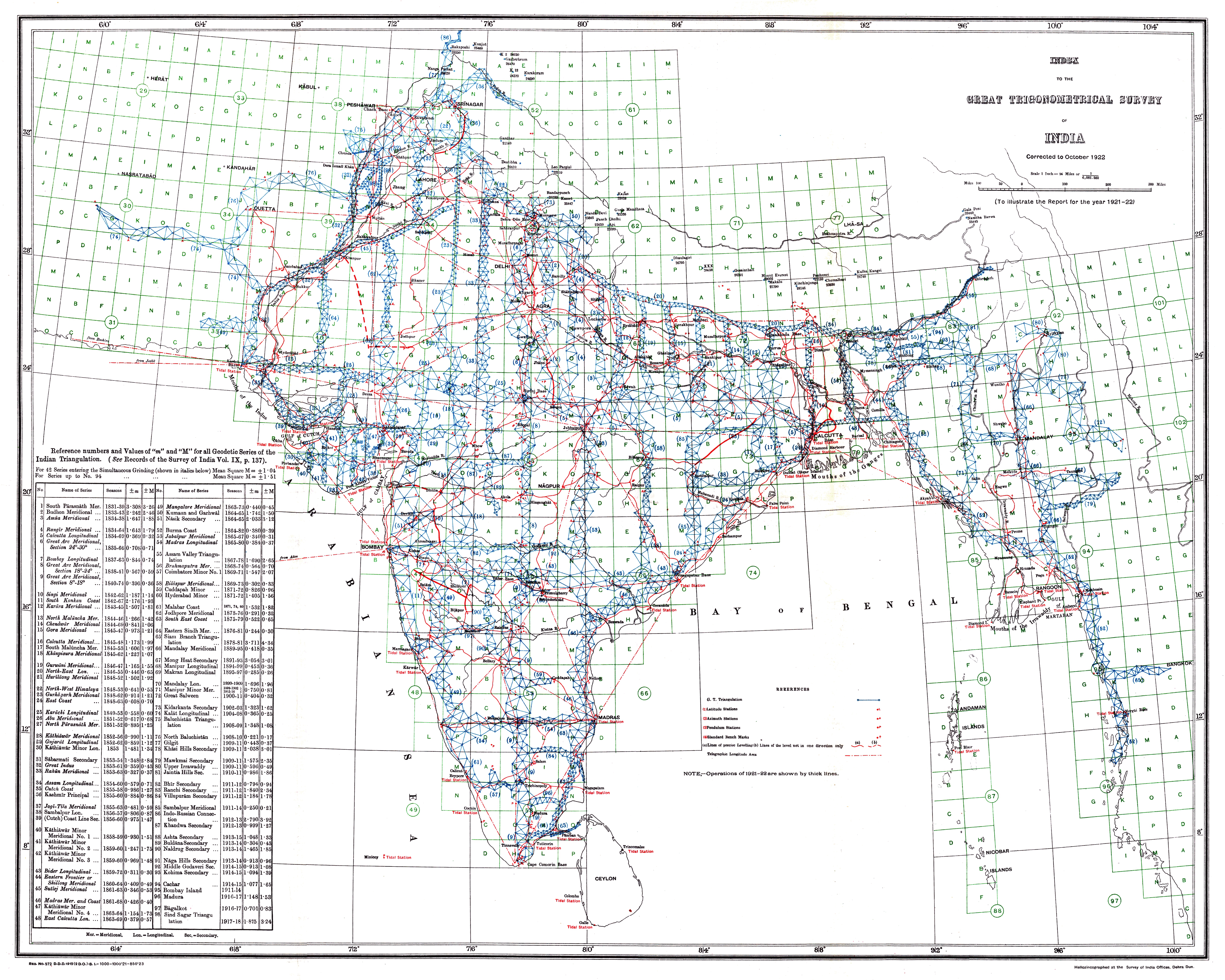
Index to the Great Trigonometrical Survey of India (1922). India is shown on a 1-degree grid of green lines. The blue triangles indicate the Great Trigonometrical w:triangulation measurements. Triangulation series are indicated by a number in parentheses. These series are described in the table at the bottom left. The red dash-dot lines are telegraph longitude area. Among the many accomplishments of the Survey were the demarcation of the British territories in India and the measurement of the height of the Himalayan giants: Everest, K2, and Kanchenjunga. |
|||||||||
| ದಿನಾಂಕ | ||||||||||
| ಆಕರ | Report of the Survey of India for 1921–22 | |||||||||
| ಸೃಷ್ಟಿಕರ್ತ |
Survey of India, Government of India |
|||||||||
| Geotemporal data | ||||||||||
| Bounding box |
|
|||||||||
| Georeferencing | ||||||||||
ಪರವಾನಗಿ
ಈ ಕೆಲಸ public domain ದ India ಇದರ ಹಕ್ಕುಸ್ವಾಮ್ಯದ ಅವಧಿ ಮುಗಿದಿದೆ.
|
 |
This work is in the public domain in the United States because it was published (or registered with the U.S. Copyright Office) before January 1, 1929.
Public domain works must be out of copyright in both the United States and in the source country of the work in order to be hosted on the Commons. If the work is not a U.S. work, the file must have an additional copyright tag indicating the copyright status in the source country.
Note: This tag should not be used for sound recordings. |
Assessment
|
ಕಡತದ ಇತಿಹಾಸ
ದಿನ/ಕಾಲ ಒತ್ತಿದರೆ ಆ ಸಮಯದಲ್ಲಿ ಈ ಕಡತದ ವಸ್ತುಸ್ಥಿತಿ ತೋರುತ್ತದೆ.
| ದಿನ/ಕಾಲ | ಕಿರುನೋಟ | ಆಯಾಮಗಳು | ಬಳಕೆದಾರ | ಟಿಪ್ಪಣಿ | |
|---|---|---|---|---|---|
| ಪ್ರಸಕ್ತ | ೧೪:೨೯, ೨೬ ಸೆಪ್ಟೆಂಬರ್ ೨೦೧೩ | | ೫,೫೬೦ × ೪,೪೪೮ (೧೬.೫೪ MB) | Shyamal | {{Information |Description=Index to the Great Trigonometrical Survey of India (1922) |Source=Report of the Survey of India for 1921-22 |Date=1922 |Author=Survey of India, Government of India |Permission={{PD-1923}} |other_versions= }} [[Category:Maps... |
ಕಡತ ಬಳಕೆ
ಈ ಕೆಳಗಿನ ಪುಟವು ಈ ಚಿತ್ರಕ್ಕೆ ಸಂಪರ್ಕ ಹೊಂದಿದೆ:
ಜಾಗತಿಕ ಕಡತ ಉಪಯೋಗ
ಈ ಕಡತವನ್ನು ಕೆಳಗಿನ ಬೇರೆ ವಿಕಿಗಳೂ ಉಪಯೋಗಿಸುತ್ತಿವೆ:
- en.wikipedia.org ಮೇಲೆ ಬಳಕೆ
- Great Trigonometrical Survey
- Wikipedia:Featured pictures/Diagrams, drawings, and maps/Maps
- Wikipedia:WikiProject India/Recognized content
- Wikipedia:WikiProject India/Main page featured content
- Portal:India/Recognized content
- Wikipedia:Featured picture candidates/File:1922 Index of Great Trigonometrical Survey of India.jpg
- Wikipedia:Featured picture candidates/March-2022
- Wikipedia:Featured pictures thumbs/73
- User talk:Ixtal/Archives/2022/March
- Wikipedia:Wikipedia Signpost/2022-04-24/Featured content
- Wikipedia:Wikipedia Signpost/Single/2022-04-24
- Template:POTD/2025-08-15
- Wikipedia:Picture of the day/August 2025
- User:Ixtal/Contributions
- fr.wikipedia.org ಮೇಲೆ ಬಳಕೆ
- ko.wikipedia.org ಮೇಲೆ ಬಳಕೆ
- mr.wikipedia.org ಮೇಲೆ ಬಳಕೆ
- sh.wikipedia.org ಮೇಲೆ ಬಳಕೆ
- ta.wikipedia.org ಮೇಲೆ ಬಳಕೆ