
ಚಿತ್ರ:Koppen-Geiger Map ARG present.svg

Size of this PNG preview of this SVG file: ೫೧೨ × ೪೨೩ ಪಿಕ್ಸೆಲ್ಗಳು. ಇತರ ರೆಸಲ್ಯೂಶನ್ಗಳು: ೨೯೧ × ೨೪೦ ಪಿಕ್ಸೆಲ್ಗಳು | ೫೮೧ × ೪೮೦ ಪಿಕ್ಸೆಲ್ಗಳು | ೯೩೦ × ೭೬೮ ಪಿಕ್ಸೆಲ್ಗಳು | ೧,೨೪೦ × ೧,೦೨೪ ಪಿಕ್ಸೆಲ್ಗಳು | ೨,೪೭೯ × ೨,೦೪೮ ಪಿಕ್ಸೆಲ್ಗಳು.
ಮೂಲ ಕಡತ (SVG ಫೈಲು, ಸುಮಾರಾಗಿ ೫೧೨ × ೪೨೩ ಚಿತ್ರಬಿಂದುಗಳು, ಫೈಲಿನ ಗಾತ್ರ: ೧.೨೧ MB)
ಈ ಫೈಲು ವಿಕಿಮೀಡಿಯ ಕಾಮನ್ಸ್ನಲ್ಲಿ ಇರುವುದು. ಅಲ್ಲಿನ ವಿವರಣೆ ಪುಟವನ್ನೇ ಕೆಳಗೆ ತೋರಿಸಲಾಗಿದೆ. ಕಾಮನ್ಸ್ ಕೃತಿಸ್ವಾಮ್ಯತೆಯಿಂದ ಮುಕ್ತ ಫೈಲುಗಳ ಒಂದು ಆಗರ. ಅಲ್ಲಿ ನೀವೂ ಸಹಕರಿಸಬಹುದು. |
ಸಾರಾಂಶ
| ವಿವರ |
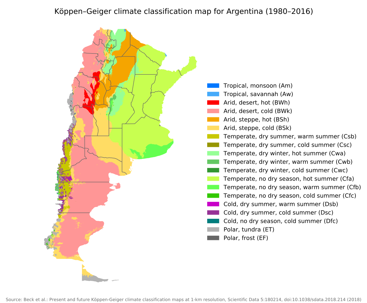
English: Köppen–Geiger climate classification map for Argentina |
| ದಿನಾಂಕ | |
| ಆಕರ | "Present and future Köppen-Geiger climate classification maps at 1-km resolution". Nature Scientific Data. DOI:10.1038/sdata.2018.214. |
| ಕರ್ತೃ | Beck, H.E., Zimmermann, N. E., McVicar, T. R., Vergopolan, N., Berg, A., & Wood, E. F. |
ಪರವಾನಗಿ
This file is licensed under the Creative Commons Attribution 4.0 International license.
- ನೀವು ಮುಕ್ತ:
- ಹಂಚಿಕೆಗೆ – ಕೆಲಸವನ್ನು ನಕಲು ಮಾಡಲು, ವಿತರಣೆ ಮತ್ತು ಸಾಗಿಸಲು
- ರೀಮಿಕ್ಸ್ ಮಾಡಲು – ಕೆಲಸವನ್ನು ಬಳಸಿಕೊಳ್ಳಲು
- ಈ ಕೆಳಗಿನ ಷರತ್ತುಗಳಲ್ಲಿ:
- ವೈಶಿಷ್ಟ್ಯ – ನೀವು ಸೂಕ್ತವಾದ ಕ್ರೆಡಿಟ್ ನೀಡಬೇಕು, ಪರವಾನಗಿಗೆ ಲಿಂಕ್ ಅನ್ನು ಒದಗಿಸಬೇಕು ಮತ್ತು ಯಾವುದೇ ಬದಲಾವಣೆಗಳನ್ನು ಮಾಡಿದ್ದರೆ ಸೂಚಿಸಬೇಕು. ನೀವು ಯಾವುದೇ ಸಮಂಜಸವಾದ ರೀತಿಯಲ್ಲಿ ಮಾಡಬಹುದು, ಆದರೆ ಪರವಾನಗಿದಾರರು ನಿಮ್ಮನ್ನು ಅಥವಾ ನಿಮ್ಮ ಯಾವುದೇ ಬಳಕೆಯನ್ನು ಅನುಮೋದಿಸಿದಂತೆ ರೀತಿಯಲ್ಲಿ ಉಪಯೋಗಿಸಬಾರದು.
| Camera location | | View this and other nearby images on: OpenStreetMap |
|---|
ಕಡತದ ಇತಿಹಾಸ
ದಿನ/ಕಾಲ ಒತ್ತಿದರೆ ಆ ಸಮಯದಲ್ಲಿ ಈ ಕಡತದ ವಸ್ತುಸ್ಥಿತಿ ತೋರುತ್ತದೆ.
| ದಿನ/ಕಾಲ | ಕಿರುನೋಟ | ಆಯಾಮಗಳು | ಬಳಕೆದಾರ | ಟಿಪ್ಪಣಿ | |
|---|---|---|---|---|---|
| ಪ್ರಸಕ್ತ | ೧೪:೪೪, ೮ ಸೆಪ್ಟೆಂಬರ್ ೨೦೨೦ | | ೫೧೨ × ೪೨೩ (೧.೨೧ MB) | Allice Hunter | Provinces and adjustments |
| ೨೧:೧೪, ೧೭ ಜುಲೈ ೨೦೨೦ |  | ೧,೨೦೮ × ೮೫೦ (೧.೫೧ MB) | JPLema | Reverted to version as of 21:36, 15 June 2020 (UTC) | |
| ೨೧:೧೩, ೧೭ ಜುಲೈ ೨೦೨೦ |  | ೮೪೦ × ೮೧೨ (೧.೪೫ MB) | JPLema | reducción de tamaño | |
| ೦೩:೦೬, ೧೬ ಜೂನ್ ೨೦೨೦ |  | ೧,೨೦೮ × ೮೫೦ (೧.೫೧ MB) | JPLema | Reverted to version as of 03:03, 26 November 2018 (UTC) | |
| ೧೮:೩೨, ೧೫ ಜೂನ್ ೨೦೨೦ |  | ೬೯೬ × ೧,೦೦೬ (೧.೩೪ MB) | JPLema | reduje el ancho y aumenté la altura | |
| ೦೮:೩೩, ೨೬ ನವೆಂಬರ್ ೨೦೧೮ |  | ೧,೨೦೮ × ೮೫೦ (೧.೫೧ MB) | NVergopolan | {{Information |Description={{en| Köppen–Geiger climate classification map for Argentina}}|date=2018-11-06|source={{cite journal | journal=Nature Scientific Data |doi=10.1038/sdata.2018.214}}|author=Beck, H.E., Zimmermann, N. E., McVicar, T. R., Vergopolan, N., Berg, A., & Wood, E. F.|permission=|other_versions=|other_fields=}}{{Cc-by-4.0}}{{Location|-38.42003918|-63.58480835}}Category:Köppen-Geiger Climate Classification MapsCategory:present climate (1980–2016)Category:Argentina[[... |
ಕಡತ ಬಳಕೆ
ಈ ಫೈಲನ್ನು ಬಳಸುವ ಯಾವ ಪುಟಗಳೂ ಇಲ್ಲ.
ಜಾಗತಿಕ ಕಡತ ಉಪಯೋಗ
ಈ ಕಡತವನ್ನು ಕೆಳಗಿನ ಬೇರೆ ವಿಕಿಗಳೂ ಉಪಯೋಗಿಸುತ್ತಿವೆ:
- bg.wikipedia.org ಮೇಲೆ ಬಳಕೆ
- ckb.wikipedia.org ಮೇಲೆ ಬಳಕೆ
- en.wikipedia.org ಮೇಲೆ ಬಳಕೆ
- id.wikipedia.org ಮೇಲೆ ಬಳಕೆ
- ja.wikipedia.org ಮೇಲೆ ಬಳಕೆ
- km.wikipedia.org ಮೇಲೆ ಬಳಕೆ
- pt.wikipedia.org ಮೇಲೆ ಬಳಕೆ
- ru.wikipedia.org ಮೇಲೆ ಬಳಕೆ
- sr.wikipedia.org ಮೇಲೆ ಬಳಕೆ
- tr.wikipedia.org ಮೇಲೆ ಬಳಕೆ
- uk.wikipedia.org ಮೇಲೆ ಬಳಕೆ