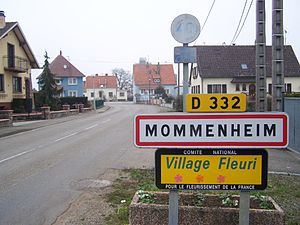
Mommenheim
ಗೋಚರ
commune in Bas-Rhin, France
ಉದಾಹರಣೆಗೆ
commune of France
ಅಧಿಕೃತ ಹೆಸರು
Mommenheim[೫]
native label
Mùmmle
ಸ್ಥಳ: Wolschheim
ದೇಶ
ಈ ಪ್ರದೇಶದಲ್ಲಿದೆ
Unterelsaß
ಆರಂಭದ ಸಮಯ: 1871
ಅಂತ್ಯದ ಸಮಯ: 1920
ಬಾಸ್-ರೈನ್
ಆರಂಭದ ಸಮಯ: 1920
ಬಾಸ್-ರೈನ್
ಅಂತ್ಯದ ಸಮಯ: 1871
ಆರಂಭದ ಸಮಯ: ೪ ಮಾರ್ಚ್ 1790
arrondissement of Haguenau-Wissembourg
ಆರಂಭದ ಸಮಯ: ೧ ಜನವರಿ 2015
arrondissement of Strasbourg-Campagne
ಅಂತ್ಯದ ಸಮಯ: ೩೧ ಡಿಸೆಂಬರ್ 2014
located in time zone
UTC+01:00
valid in period: ಪ್ರಮಾಣಿತ ಸಮಯ
UTC+02:00
valid in period: daylight saving time
located in statistical territorial entity
Q108921852
associated electoral district
ಸ್ಥಳದ ನಿರ್ದೇಶಾಂಕಗಳ
office held by head of government
Mayor of Mommenheim
ಸಮುದ್ರ ಮಟ್ಟದಿಂದ ಇರುವ ಎತ್ತರ
twinned administrative body
ಇವುಗಳೊಂದಿಗೆ ಗಡಿ ಹಂಚಿಕೊಂಡಿದೆ
Schwindratzheim
Bernolsheim
Hochstett
Krautwiller
Minversheim
Wahlenheim
Waltenheim-sur-Zorn
Wingersheim-les-Quatre-Bans
Wittersheim
area
೮.೧೬ ಚದರ ಕಿ.ಮಿ.[೭]
postal code
67670[೧೨]
phone number
+33-3-88-51-62-05[೧೩]
fax number
+33-3-88-51-52-34[೧೩]
email address
ಅಧಿಕೃತ ಜಾಲತಾಣ
different from
Mommenheim
ಕಾಮನ್ಸ್ ವರ್ಗ
Mommenheim (Bas-Rhin)
ವಿಷಯದ ಮುಖ್ಯ ವರ್ಗ
Category:Mommenheim (Bas-Rhin)
ಈ ಸ್ಥಳದಲ್ಲಿ ಜನಿಸಿರುವ ಜನರ ವರ್ಗ
Q18665021
category for maps
Category:Maps of Mommenheim (Bas-Rhin)
Reference
- ↑ Freebase Data Dumps, ೨೮ ಅಕ್ಟೋಬರ್ 2013
- ↑ GeoNames
- ↑ BnF authorities, ೨೬ ಆಗಸ್ಟ್ 2015
- ↑ National Library of Israel Names and Subjects Authority File
- ↑ Code officiel géographique, https://www.insee.fr/fr/information/3363419, ೬ ಜನವರಿ 2019
- ↑ Code officiel géographique, ೨೨ ಸೆಪ್ಟೆಂಬರ್ 2017, https://www.insee.fr/fr/information/2560698
- ↑ ೭.೦ ೭.೧ répertoire géographique des communes, ೨೬ ಅಕ್ಟೋಬರ್ 2015
- ↑ Populations légales 2021
- ↑ ೯.೦ ೯.೧ The National Institute of Statistics and Economic Studies
- ↑ ೧೦.೦ ೧೦.೧ répertoire géographique des communes, https://wxs-telechargement.ign.fr/83edtfdyqte031y0ra49d2e3/telechargement/inspire/RGC-2015-01$RGC2015/file/RGC2015.7z, RGC_2015.txt, 2015, http://web.archive.org/web/20160804005551if_/https://wxs-telechargement.ign.fr/83edtfdyqte031y0ra49d2e3/telechargement/inspire/RGC-2015-01$RGC2015/file/RGC2015.7z
- ↑ ೨೦ ಆಗಸ್ಟ್ 2019, https://www.buehl.de/pb/microsites-buehl/Microsite+Vimbuch/Partnerstadt.html
- ↑ dataset of postal codes in France, ೧ ಅಕ್ಟೋಬರ್ 2018
- ↑ ೧೩.೦ ೧೩.೧ ೧೩.೨ ೧೩.೩ Annuaire de service-public.fr, ೨೪ ಸೆಪ್ಟೆಂಬರ್ 2023


