
ಚಿತ್ರ:White and Blue Nile-en.svg

Size of this PNG preview of this SVG file: ೪೩೮ × ೫೭೨ ಪಿಕ್ಸೆಲ್ಗಳು. ಇತರ ರೆಸಲ್ಯೂಶನ್ಗಳು: ೧೮೪ × ೨೪೦ ಪಿಕ್ಸೆಲ್ಗಳು | ೩೬೭ × ೪೮೦ ಪಿಕ್ಸೆಲ್ಗಳು | ೫೮೮ × ೭೬೮ ಪಿಕ್ಸೆಲ್ಗಳು | ೭೮೪ × ೧,೦೨೪ ಪಿಕ್ಸೆಲ್ಗಳು | ೧,೫೬೮ × ೨,೦೪೮ ಪಿಕ್ಸೆಲ್ಗಳು.
ಮೂಲ ಕಡತ (SVG ಫೈಲು, ಸುಮಾರಾಗಿ ೪೩೮ × ೫೭೨ ಚಿತ್ರಬಿಂದುಗಳು, ಫೈಲಿನ ಗಾತ್ರ: ೪೭೨ KB)
ಈ ಫೈಲು ವಿಕಿಮೀಡಿಯ ಕಾಮನ್ಸ್ನಲ್ಲಿ ಇರುವುದು. ಅಲ್ಲಿನ ವಿವರಣೆ ಪುಟವನ್ನೇ ಕೆಳಗೆ ತೋರಿಸಲಾಗಿದೆ. ಕಾಮನ್ಸ್ ಕೃತಿಸ್ವಾಮ್ಯತೆಯಿಂದ ಮುಕ್ತ ಫೈಲುಗಳ ಒಂದು ಆಗರ. ಅಲ್ಲಿ ನೀವೂ ಸಹಕರಿಸಬಹುದು. |
| ವಿವರ | |
| ದಿನಾಂಕ | (UTC) |
| ಆಕರ | |
| ಕರ್ತೃ |
|
| ಇತರೆ ಆವೃತ್ತಿಗಳು |
|


I, the copyright holder of this work, hereby publish it under the following license:
This file is licensed under the Creative Commons Attribution-Share Alike 2.5 Generic, 2.0 Generic and 1.0 Generic license.
- ನೀವು ಮುಕ್ತ:
- ಹಂಚಿಕೆಗೆ – ಕೆಲಸವನ್ನು ನಕಲು ಮಾಡಲು, ವಿತರಣೆ ಮತ್ತು ಸಾಗಿಸಲು
- ರೀಮಿಕ್ಸ್ ಮಾಡಲು – ಕೆಲಸವನ್ನು ಬಳಸಿಕೊಳ್ಳಲು
- ಈ ಕೆಳಗಿನ ಷರತ್ತುಗಳಲ್ಲಿ:
- ವೈಶಿಷ್ಟ್ಯ – ನೀವು ಸೂಕ್ತವಾದ ಕ್ರೆಡಿಟ್ ನೀಡಬೇಕು, ಪರವಾನಗಿಗೆ ಲಿಂಕ್ ಅನ್ನು ಒದಗಿಸಬೇಕು ಮತ್ತು ಯಾವುದೇ ಬದಲಾವಣೆಗಳನ್ನು ಮಾಡಿದ್ದರೆ ಸೂಚಿಸಬೇಕು. ನೀವು ಯಾವುದೇ ಸಮಂಜಸವಾದ ರೀತಿಯಲ್ಲಿ ಮಾಡಬಹುದು, ಆದರೆ ಪರವಾನಗಿದಾರರು ನಿಮ್ಮನ್ನು ಅಥವಾ ನಿಮ್ಮ ಯಾವುದೇ ಬಳಕೆಯನ್ನು ಅನುಮೋದಿಸಿದಂತೆ ರೀತಿಯಲ್ಲಿ ಉಪಯೋಗಿಸಬಾರದು.
- ಇರುವುದರಂತೆಯೇ ಹಂಚು – ನೀವು ರೀಮಿಕ್ಸ್ ಮಾಡಿದರೆ, ರೂಪಾಂತರಗೊಳಿಸಿದರೆ ಅಥವಾ ವಸ್ತುವಿನ ಮೇಲೆ ನಿರ್ಮಿಸಿದರೆ, ನಿಮ್ಮ ಕೊಡುಗೆಗಳನ್ನು ನೀವು ಮೂಲದಂತೆ ಅದೇ ಅಥವಾ ಹೊಂದಾಣಿಕೆಯ ಪರವಾನಗಿ ಅಡಿಯಲ್ಲಿ ವಿತರಿಸಬೇಕು.
Original upload log
This image is a derivative work of the following images:
- File:Nile-en.svg licensed with Cc-by-sa-2.5,2.0,1.0
- 2010-06-14T12:51:42Z Cryonic07 640x730 (756114 Bytes) {{Information |Description={{en|Map of the [[:en:Nile|Nile]] river.}} |Source=*[[:File:African_continent-en.svg|]] |Date=2010-06-14 12:46 (UTC) |Author=*[[:File:African_continent-en.svg|]]: *derivative work: [[User:Bobarino|B
Uploaded with derivativeFX
ಕಡತದ ಇತಿಹಾಸ
ದಿನ/ಕಾಲ ಒತ್ತಿದರೆ ಆ ಸಮಯದಲ್ಲಿ ಈ ಕಡತದ ವಸ್ತುಸ್ಥಿತಿ ತೋರುತ್ತದೆ.
| ದಿನ/ಕಾಲ | ಕಿರುನೋಟ | ಆಯಾಮಗಳು | ಬಳಕೆದಾರ | ಟಿಪ್ಪಣಿ | |
|---|---|---|---|---|---|
| ಪ್ರಸಕ್ತ | ೨೩:೩೯, ೬ ಆಗಸ್ಟ್ ೨೦೧೩ | | ೪೩೮ × ೫೭೨ (೪೭೨ KB) | Hel-hama | northern section of map cropped |
| ೨೩:೨೩, ೬ ಆಗಸ್ಟ್ ೨೦೧೩ |  | ೪೩೮ × ೮೦೨ (೪೭೨ KB) | Hel-hama | Improved version of map to include lower Nile | |
| ೦೯:೩೦, ೨೦ ಸೆಪ್ಟೆಂಬರ್ ೨೦೧೧ |  | ೩೬೫ × ೪೮೦ (೬೨೭ KB) | Alphathon | Added South Sudan using borders from File:South_Sudan-CIA_WFB_Map.png | |
| ೧೬:೪೧, ೧೫ ಜೂನ್ ೨೦೧೦ |  | ೩೬೫ × ೪೮೦ (೭೪೧ KB) | Cryonic07 | font size | |
| ೧೪:೫೮, ೧೫ ಜೂನ್ ೨೦೧೦ |  | ೩೬೫ × ೪೮೦ (೭೪೧ KB) | Cryonic07 | Italics. Lake Tana, Khartoum, Juba and Jinja marked | |
| ೦೦:೪೭, ೧೫ ಜೂನ್ ೨೦೧೦ |  | ೩೬೫ × ೪೮೦ (೭೩೬ KB) | Cryonic07 | Tanzania was not marked on the map | |
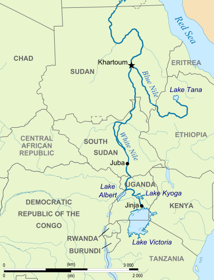
| ೧೯:೨೬, ೧೪ ಜೂನ್ ೨೦೧೦ |  | ೩೬೫ × ೪೮೦ (೭೩೪ KB) | Cryonic07 | {{Information |Description={{en|Map showing the White Nile and the Blue Nile}} |Source=*File:Nile-en.svg |Date=2010-06-14 13:32 (UTC) |Author=*File:Nile-en.svg: *[[:File:African_continent-en.svg|African_con |
ಕಡತ ಬಳಕೆ
ಈ ಕೆಳಗಿನ ಪುಟವು ಈ ಚಿತ್ರಕ್ಕೆ ಸಂಪರ್ಕ ಹೊಂದಿದೆ:
ಜಾಗತಿಕ ಕಡತ ಉಪಯೋಗ
ಈ ಕಡತವನ್ನು ಕೆಳಗಿನ ಬೇರೆ ವಿಕಿಗಳೂ ಉಪಯೋಗಿಸುತ್ತಿವೆ:
- af.wikipedia.org ಮೇಲೆ ಬಳಕೆ
- ast.wikipedia.org ಮೇಲೆ ಬಳಕೆ
- ba.wikipedia.org ಮೇಲೆ ಬಳಕೆ
- br.wikipedia.org ಮೇಲೆ ಬಳಕೆ
- ca.wikipedia.org ಮೇಲೆ ಬಳಕೆ
- da.wikipedia.org ಮೇಲೆ ಬಳಕೆ
- de.wikipedia.org ಮೇಲೆ ಬಳಕೆ
- el.wikipedia.org ಮೇಲೆ ಬಳಕೆ
- en.wikipedia.org ಮೇಲೆ ಬಳಕೆ
- eo.wikipedia.org ಮೇಲೆ ಬಳಕೆ
- fa.wikipedia.org ಮೇಲೆ ಬಳಕೆ
- fo.wikipedia.org ಮೇಲೆ ಬಳಕೆ
- fr.wikipedia.org ಮೇಲೆ ಬಳಕೆ
- hu.wikipedia.org ಮೇಲೆ ಬಳಕೆ
- id.wikipedia.org ಮೇಲೆ ಬಳಕೆ
- ilo.wikipedia.org ಮೇಲೆ ಬಳಕೆ
- ja.wikipedia.org ಮೇಲೆ ಬಳಕೆ
- lv.wikipedia.org ಮೇಲೆ ಬಳಕೆ
- ml.wikipedia.org ಮೇಲೆ ಬಳಕೆ
- nl.wikipedia.org ಮೇಲೆ ಬಳಕೆ
- no.wikipedia.org ಮೇಲೆ ಬಳಕೆ
- pl.wikipedia.org ಮೇಲೆ ಬಳಕೆ
- ru.wikipedia.org ಮೇಲೆ ಬಳಕೆ
- sh.wikipedia.org ಮೇಲೆ ಬಳಕೆ
- sk.wikipedia.org ಮೇಲೆ ಬಳಕೆ
- sr.wikipedia.org ಮೇಲೆ ಬಳಕೆ
- sw.wikipedia.org ಮೇಲೆ ಬಳಕೆ
- ta.wikipedia.org ಮೇಲೆ ಬಳಕೆ
- uz.wikipedia.org ಮೇಲೆ ಬಳಕೆ
- yi.wikipedia.org ಮೇಲೆ ಬಳಕೆ
- zh.wikipedia.org ಮೇಲೆ ಬಳಕೆ