
ಚಿತ್ರ:Wales relief location map.jpg
ಈ ಮುನ್ನೋಟ ಗಾತ್ರ:೫೦೨ × ೬೦೦ ಪಿಕ್ಸೆಲ್ಗಳು. ಇತರ ರೆಸಲ್ಯೂಶನ್ಗಳು: ೨೦೧ × ೨೪೦ ಪಿಕ್ಸೆಲ್ಗಳು | ೪೦೨ × ೪೮೦ ಪಿಕ್ಸೆಲ್ಗಳು | ೬೪೩ × ೭೬೮ ಪಿಕ್ಸೆಲ್ಗಳು | ೮೫೭ × ೧,೦೨೪ ಪಿಕ್ಸೆಲ್ಗಳು | ೨,೦೦೦ × ೨,೩೯೦ ಪಿಕ್ಸೆಲ್ಗಳು.
ಮೂಲ ಕಡತ (೨,೦೦೦ × ೨,೩೯೦ ಚಿತ್ರಬಿಂದು, ಫೈಲಿನ ಗಾತ್ರ: ೭೪೨ KB, MIME ಪ್ರಕಾರ: image/jpeg)
ಈ ಫೈಲು ವಿಕಿಮೀಡಿಯ ಕಾಮನ್ಸ್ನಲ್ಲಿ ಇರುವುದು. ಅಲ್ಲಿನ ವಿವರಣೆ ಪುಟವನ್ನೇ ಕೆಳಗೆ ತೋರಿಸಲಾಗಿದೆ. ಕಾಮನ್ಸ್ ಕೃತಿಸ್ವಾಮ್ಯತೆಯಿಂದ ಮುಕ್ತ ಫೈಲುಗಳ ಒಂದು ಆಗರ. ಅಲ್ಲಿ ನೀವೂ ಸಹಕರಿಸಬಹುದು. |
| ವಿವರ |
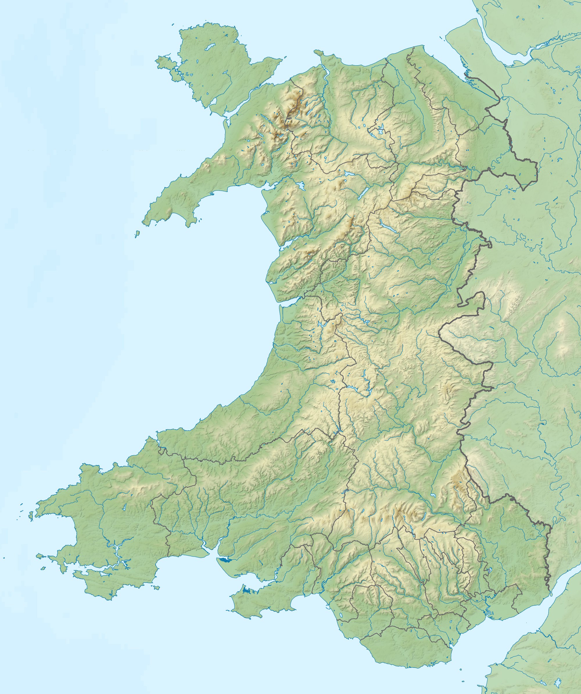
Relief map of Wales, UK. Equirectangular map projection on WGS 84 datum, with N/S stretched 170%
|
| ದಿನಾಂಕ | |
| ಆಕರ |
|
| ಕರ್ತೃ | Nilfanion, created using Ordnance Survey data |
| ಅನುಮತಿ (ಈ ಕಡತವನ್ನು ಮರುಬಳಕೆ ಮಾಡಲಾಗುತ್ತಿದೆ) |
ಈ ಕಡತ ಕ್ರಿಯೇಟಿವ್ ಕಾಮನ್ಸ್ Attribution
-Share Alike 3.0 Unported ಪರವಾನಗಿ ಹೊಂದಿದೆ. ವೈಶಿಷ್ಟ್ಯ: Contains Ordnance Survey data © Crown copyright and database right
|
| ಇತರೆ ಆವೃತ್ತಿಗಳು | File:Wales location map.svg - Blank map |
ಕಡತದ ಇತಿಹಾಸ
ದಿನ/ಕಾಲ ಒತ್ತಿದರೆ ಆ ಸಮಯದಲ್ಲಿ ಈ ಕಡತದ ವಸ್ತುಸ್ಥಿತಿ ತೋರುತ್ತದೆ.
| ದಿನ/ಕಾಲ | ಕಿರುನೋಟ | ಆಯಾಮಗಳು | ಬಳಕೆದಾರ | ಟಿಪ್ಪಣಿ | |
|---|---|---|---|---|---|
| ಪ್ರಸಕ್ತ | ೧೭:೨೩, ೯ ಡಿಸೆಂಬರ್ ೨೦೧೧ | | ೨,೦೦೦ × ೨,೩೯೦ (೭೪೨ KB) | Nilfanion | {{Information |Description=Relief map of Wales, UK. Equirectangular map projection on WGS 84 datum, with N/S stretched 170% *West: 5.5W *East: 2.5W *North: 53.5N *South: 51.3N |Source=Ordnance Survey [https://www.ordnan |
ಕಡತ ಬಳಕೆ
ಈ ಕೆಳಗಿನ ಪುಟವು ಈ ಚಿತ್ರಕ್ಕೆ ಸಂಪರ್ಕ ಹೊಂದಿದೆ:
ಜಾಗತಿಕ ಕಡತ ಉಪಯೋಗ
ಈ ಕಡತವನ್ನು ಕೆಳಗಿನ ಬೇರೆ ವಿಕಿಗಳೂ ಉಪಯೋಗಿಸುತ್ತಿವೆ:
- ar.wikipedia.org ಮೇಲೆ ಬಳಕೆ
- ast.wikipedia.org ಮೇಲೆ ಬಳಕೆ
- az.wikipedia.org ಮೇಲೆ ಬಳಕೆ
- ba.wikipedia.org ಮೇಲೆ ಬಳಕೆ
- bg.wikipedia.org ಮೇಲೆ ಬಳಕೆ
- Ланголен
- Кардиф
- Суонзи
- Брекън
- Нюпорт
- Мърдър Тидфил (град)
- Денби
- Тремадог
- Колуин Бей
- Уитфорд
- Бангор (Уелс)
- Сейнт Дейвидс
- Ъск
- Престатин
- Рил
- Коруен
- Карог
- Ридлан
- Ридин
- Сейнт Асаф
- Моулд
- Багилт
- Бъкли
- Ъстрад Мънах
- Кайруис
- Конас Кий
- Юлоу
- Флинт (Уелс)
- Хардън
- Бротън
- Хоулиуел
- Куинсфери
- Солтни
- Шотън
- Чърк
- Рексъм (град)
- Амлух
- Биумарис
- Бенлех
- Хоулихед
- Лангевни
- Менай Бридж
- Абергеле
- Конуи (град)
ಈ ಫೈಲ್ನ ಹೆಚ್ಚು ಜಾಗತಿಕ ಬಳಕೆಯನ್ನು ವೀಕ್ಷಿಸಿ.