
ಚಿತ್ರ:Ukraine under russian occupation grey.svg

Size of this PNG preview of this SVG file: ೮೦೦ × ೫೩೮ ಪಿಕ್ಸೆಲ್ಗಳು. ಇತರ ರೆಸಲ್ಯೂಶನ್ಗಳು: ೩೨೦ × ೨೧೫ ಪಿಕ್ಸೆಲ್ಗಳು | ೬೪೦ × ೪೩೦ ಪಿಕ್ಸೆಲ್ಗಳು | ೧,೦೨೪ × ೬೮೮ ಪಿಕ್ಸೆಲ್ಗಳು | ೧,೨೮೦ × ೮೬೦ ಪಿಕ್ಸೆಲ್ಗಳು | ೨,೫೬೦ × ೧,೭೨೦ ಪಿಕ್ಸೆಲ್ಗಳು | ೩,೭೮೦ × ೨,೫೪೦ ಪಿಕ್ಸೆಲ್ಗಳು.
ಮೂಲ ಕಡತ (SVG ಫೈಲು, ಸುಮಾರಾಗಿ ೩,೭೮೦ × ೨,೫೪೦ ಚಿತ್ರಬಿಂದುಗಳು, ಫೈಲಿನ ಗಾತ್ರ: ೧.೮ MB)
ಈ ಫೈಲು ವಿಕಿಮೀಡಿಯ ಕಾಮನ್ಸ್ನಲ್ಲಿ ಇರುವುದು. ಅಲ್ಲಿನ ವಿವರಣೆ ಪುಟವನ್ನೇ ಕೆಳಗೆ ತೋರಿಸಲಾಗಿದೆ. ಕಾಮನ್ಸ್ ಕೃತಿಸ್ವಾಮ್ಯತೆಯಿಂದ ಮುಕ್ತ ಫೈಲುಗಳ ಒಂದು ಆಗರ. ಅಲ್ಲಿ ನೀವೂ ಸಹಕರಿಸಬಹುದು. |
ಸಾರಾಂಶ
| ವಿವರ |
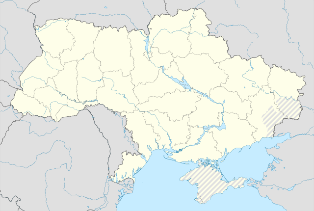
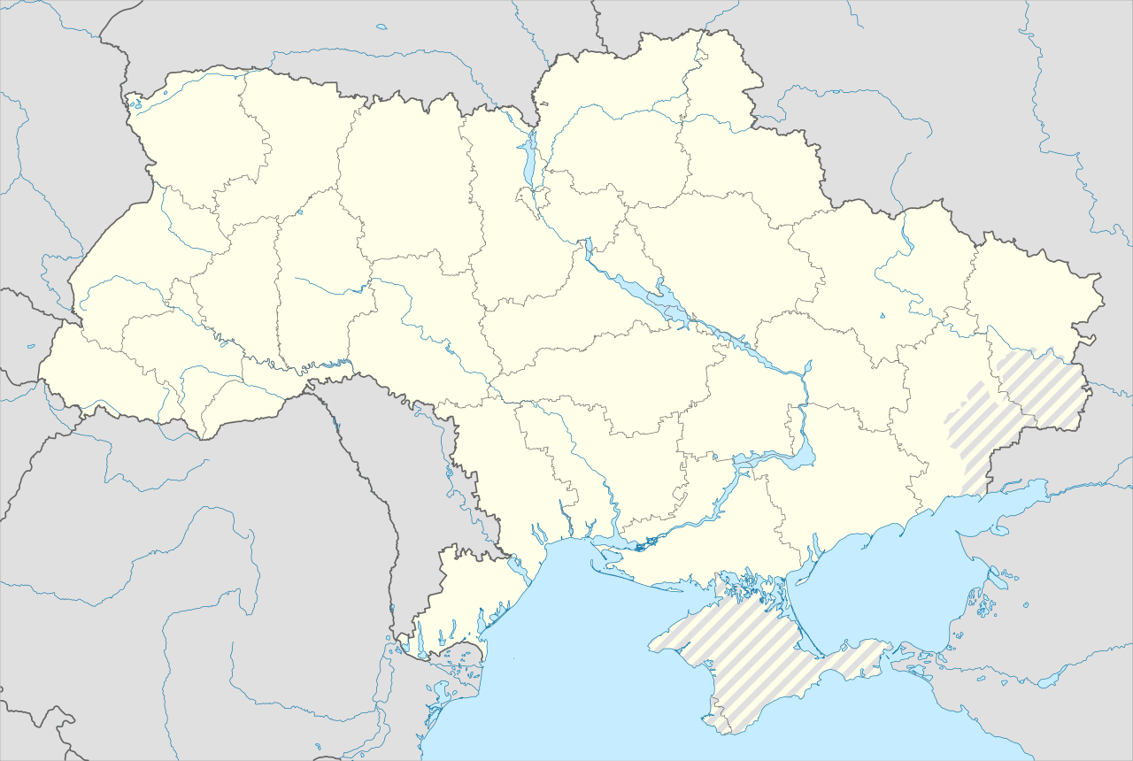
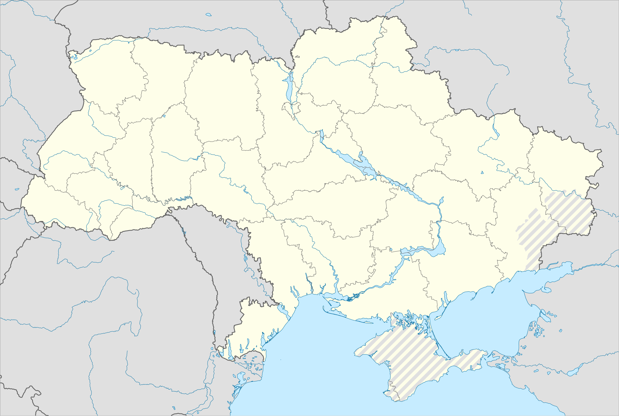
English: Location map of Ukraine under Russian occupation.
Українська: Карта України з зонами російської окупації. |
| ದಿನಾಂಕ | |
| ಆಕರ |
Own work using: Ukraine adm location map improved.svg, according to
|
| ಕರ್ತೃ | Yakiv Gluck |
| ಇತರೆ ಆವೃತ್ತಿಗಳು |
|
| SVG genesis | This map was created with Adobe Illustrator. |


ಪರವಾನಗಿ
I, the copyright holder of this work, hereby publish it under the following license:
This file is licensed under the Creative Commons Attribution-Share Alike 4.0 International license.
- ನೀವು ಮುಕ್ತ:
- ಹಂಚಿಕೆಗೆ – ಕೆಲಸವನ್ನು ನಕಲು ಮಾಡಲು, ವಿತರಣೆ ಮತ್ತು ಸಾಗಿಸಲು
- ರೀಮಿಕ್ಸ್ ಮಾಡಲು – ಕೆಲಸವನ್ನು ಬಳಸಿಕೊಳ್ಳಲು
- ಈ ಕೆಳಗಿನ ಷರತ್ತುಗಳಲ್ಲಿ:
- ವೈಶಿಷ್ಟ್ಯ – ನೀವು ಸೂಕ್ತವಾದ ಕ್ರೆಡಿಟ್ ನೀಡಬೇಕು, ಪರವಾನಗಿಗೆ ಲಿಂಕ್ ಅನ್ನು ಒದಗಿಸಬೇಕು ಮತ್ತು ಯಾವುದೇ ಬದಲಾವಣೆಗಳನ್ನು ಮಾಡಿದ್ದರೆ ಸೂಚಿಸಬೇಕು. ನೀವು ಯಾವುದೇ ಸಮಂಜಸವಾದ ರೀತಿಯಲ್ಲಿ ಮಾಡಬಹುದು, ಆದರೆ ಪರವಾನಗಿದಾರರು ನಿಮ್ಮನ್ನು ಅಥವಾ ನಿಮ್ಮ ಯಾವುದೇ ಬಳಕೆಯನ್ನು ಅನುಮೋದಿಸಿದಂತೆ ರೀತಿಯಲ್ಲಿ ಉಪಯೋಗಿಸಬಾರದು.
- ಇರುವುದರಂತೆಯೇ ಹಂಚು – ನೀವು ರೀಮಿಕ್ಸ್ ಮಾಡಿದರೆ, ರೂಪಾಂತರಗೊಳಿಸಿದರೆ ಅಥವಾ ವಸ್ತುವಿನ ಮೇಲೆ ನಿರ್ಮಿಸಿದರೆ, ನಿಮ್ಮ ಕೊಡುಗೆಗಳನ್ನು ನೀವು ಮೂಲದಂತೆ ಅದೇ ಅಥವಾ ಹೊಂದಾಣಿಕೆಯ ಪರವಾನಗಿ ಅಡಿಯಲ್ಲಿ ವಿತರಿಸಬೇಕು.
ಕಡತದ ಇತಿಹಾಸ
ದಿನ/ಕಾಲ ಒತ್ತಿದರೆ ಆ ಸಮಯದಲ್ಲಿ ಈ ಕಡತದ ವಸ್ತುಸ್ಥಿತಿ ತೋರುತ್ತದೆ.
| ದಿನ/ಕಾಲ | ಕಿರುನೋಟ | ಆಯಾಮಗಳು | ಬಳಕೆದಾರ | ಟಿಪ್ಪಣಿ | |
|---|---|---|---|---|---|
| ಪ್ರಸಕ್ತ | ೧೨:೨೩, ೧೯ ಜೂನ್ ೨೦೨೩ | | ೩,೭೮೦ × ೨,೫೪೦ (೧.೮ MB) | Physeters | Reverted to version as of 02:11, 12 May 2023 (UTC) revert removed my detail improvements in the Dnieper delta and is no longer accurate |
| ೦೩:೧೮, ೧೯ ಜೂನ್ ೨೦೨೩ |  | ೩,೭೮೦ × ೨,೫೪೦ (೧.೫೪ MB) | Yeagvr | Reverted to version as of 17:23, 3 October 2022 (UTC) | |
| ೦೭:೪೧, ೧೨ ಮೇ ೨೦೨೩ |  | ೩,೭೮೦ × ೨,೫೪೦ (೧.೮ MB) | Physeters | add improved tracing of the Dnieper Delta | |
| ೦೭:೦೦, ೪ ಅಕ್ಟೋಬರ್ ೨೦೨೨ |  | ೩,೭೮೦ × ೨,೫೪೦ (೧.೩೬ MB) | Tol | Reverted to version as of 17:17, 3 March 2018 (UTC): this substantially changes a file that was not expected to be updated, this file is intentionally different from File:Ukraine under russian occupation.svg | |
| ೨೨:೫೩, ೩ ಅಕ್ಟೋಬರ್ ೨೦೨೨ |  | ೩,೭೮೦ × ೨,೫೪೦ (೧.೫೪ MB) | Janitoalevic | Updated. | |
| ೨೨:೪೭, ೩ ಮಾರ್ಚ್ ೨೦೧೮ |  | ೩,೭೮೦ × ೨,೫೪೦ (೧.೩೬ MB) | Yakiv Gluck | improved using new adm loc map | |
| ೦೭:೦೬, ೨೭ ಜನವರಿ ೨೦೧೮ |  | ೧,೫೪೬ × ೧,೦೩೮ (೪೫೭ KB) | Yakiv Gluck | {{Information |Description ={{en|Location map of Ukraine under russian occupation.}} {{uk|Карта України з зонами російської окупації.}} |Source =own work, using [[:F... |
ಕಡತ ಬಳಕೆ
ಈ ಫೈಲನ್ನು ಬಳಸುವ ಯಾವ ಪುಟಗಳೂ ಇಲ್ಲ.
ಜಾಗತಿಕ ಕಡತ ಉಪಯೋಗ
ಈ ಕಡತವನ್ನು ಕೆಳಗಿನ ಬೇರೆ ವಿಕಿಗಳೂ ಉಪಯೋಗಿಸುತ್ತಿವೆ:
- bcl.wikipedia.org ಮೇಲೆ ಬಳಕೆ
- bn.wikipedia.org ಮೇಲೆ ಬಳಕೆ
- en.wikipedia.org ಮೇಲೆ ಬಳಕೆ
- Chernobyl
- Geography of Ukraine
- Poltava
- Kerch
- Sevastopol
- Tarashcha
- Yalta
- Nestor Makhno
- Sverdlovsk, Ukraine
- Chernivtsi
- Kaniv
- Halych
- Pripyat
- Lutsk
- Drohobych
- Kovel
- Ivano-Frankivsk
- Kalush, Ukraine
- Volodymyr (city)
- Kortelisy
- Starobilsk
- Uzhhorod
- Chernihiv
- Sumy
- Staryi Ostropil
- Kyiv
- Kosivka, Odesa Oblast
- Kosiv
- Shpola
- Mukachevo
- Simferopol
- Irpin
- Khmelnytskyi
- Fastiv
- Boltysh crater
ಈ ಫೈಲ್ನ ಹೆಚ್ಚು ಜಾಗತಿಕ ಬಳಕೆಯನ್ನು ವೀಕ್ಷಿಸಿ.