
ಚಿತ್ರ:Tularosa-Basin-NM-USGS-map opaque.gif
ಈ ಮುನ್ನೋಟ ಗಾತ್ರ:೪೪೭ × ೫೯೯ ಪಿಕ್ಸೆಲ್ಗಳು. ಇತರ ರೆಸಲ್ಯೂಶನ್ಗಳು: ೧೭೯ × ೨೪೦ ಪಿಕ್ಸೆಲ್ಗಳು | ೬೨೪ × ೮೩೬ ಪಿಕ್ಸೆಲ್ಗಳು.
ಮೂಲ ಕಡತ (೬೨೪ × ೮೩೬ ಚಿತ್ರಬಿಂದು, ಫೈಲಿನ ಗಾತ್ರ: ೫೯ KB, MIME ಪ್ರಕಾರ: image/gif)
ಈ ಫೈಲು ವಿಕಿಮೀಡಿಯ ಕಾಮನ್ಸ್ನಲ್ಲಿ ಇರುವುದು. ಅಲ್ಲಿನ ವಿವರಣೆ ಪುಟವನ್ನೇ ಕೆಳಗೆ ತೋರಿಸಲಾಗಿದೆ. ಕಾಮನ್ಸ್ ಕೃತಿಸ್ವಾಮ್ಯತೆಯಿಂದ ಮುಕ್ತ ಫೈಲುಗಳ ಒಂದು ಆಗರ. ಅಲ್ಲಿ ನೀವೂ ಸಹಕರಿಸಬಹುದು. |
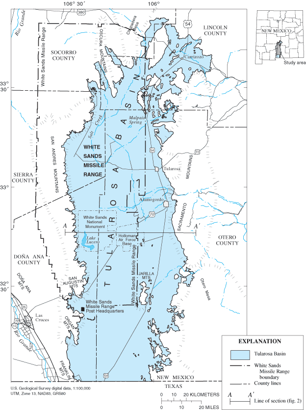
| ವಿವರ | Location map of Tularosa Basin 2004. Huff, Glenn F. (2005) "Simulation of Ground-Water Flow in the Basin-Fill Aquifer of the Tularosa Basin, South-Central New Mexico, Predevelopment through 2040" Scientific Investigations Report 2004-5197, United States Geological Survey, Washongton, D.C., fig. 1. | |||
| ದಿನಾಂಕ | ||||
| ಆಕರ |
USGS (https://pubs.er.usgs.gov/usgspubs/sir/sir20045197) http://pubs.usgs.gov/sir/2004/5197/ http://pubs.usgs.gov/sir/2004/5197/images/fig1.gif |
|||
| ಕರ್ತೃ | Huff, Glenn F. (United States Geological Survey) | |||
| ಅನುಮತಿ (ಈ ಕಡತವನ್ನು ಮರುಬಳಕೆ ಮಾಡಲಾಗುತ್ತಿದೆ) |
|
|||
| ಇತರೆ ಆವೃತ್ತಿಗಳು | Image:Tularosa-Basin-NM-USGS-map.gif (transparent version) |
ಕಡತದ ಇತಿಹಾಸ
ದಿನ/ಕಾಲ ಒತ್ತಿದರೆ ಆ ಸಮಯದಲ್ಲಿ ಈ ಕಡತದ ವಸ್ತುಸ್ಥಿತಿ ತೋರುತ್ತದೆ.
| ದಿನ/ಕಾಲ | ಕಿರುನೋಟ | ಆಯಾಮಗಳು | ಬಳಕೆದಾರ | ಟಿಪ್ಪಣಿ | |
|---|---|---|---|---|---|
| ಪ್ರಸಕ್ತ | ೧೮:೨೦, ೧೧ ಡಿಸೆಂಬರ್ ೨೦೦೭ | | ೬೨೪ × ೮೩೬ (೫೯ KB) | AnonMoos | actual opaque version |
| ೧೧:೨೫, ೭ ಅಕ್ಟೋಬರ್ ೨೦೦೭ |  | ೬೨೪ × ೮೩೬ (೬೧ KB) | Balmung0731 | {{Information |Description=Location map of Tularosa Basin 2004. Huff, Glenn F. (2005) "Simulation of Ground-Water Flow in the Basin-Fill Aquifer of the Tularosa Basin, South-Central New Mexico, Predevelopment through 2040" Scientific Investigations Report |
ಕಡತ ಬಳಕೆ
ಈ ಫೈಲನ್ನು ಬಳಸುವ ಯಾವ ಪುಟಗಳೂ ಇಲ್ಲ.
ಜಾಗತಿಕ ಕಡತ ಉಪಯೋಗ
ಈ ಕಡತವನ್ನು ಕೆಳಗಿನ ಬೇರೆ ವಿಕಿಗಳೂ ಉಪಯೋಗಿಸುತ್ತಿವೆ:
- bg.wikipedia.org ಮೇಲೆ ಬಳಕೆ
- en.wikipedia.org ಮೇಲೆ ಬಳಕೆ
- fa.wikipedia.org ಮೇಲೆ ಬಳಕೆ
- fr.wikipedia.org ಮೇಲೆ ಬಳಕೆ
- he.wikipedia.org ಮೇಲೆ ಬಳಕೆ
- hu.wikipedia.org ಮೇಲೆ ಬಳಕೆ
- ko.wikipedia.org ಮೇಲೆ ಬಳಕೆ
- ru.wikipedia.org ಮೇಲೆ ಬಳಕೆ
- sv.wikipedia.org ಮೇಲೆ ಬಳಕೆ
- uk.wikipedia.org ಮೇಲೆ ಬಳಕೆ
- vi.wikipedia.org ಮೇಲೆ ಬಳಕೆ
- www.wikidata.org ಮೇಲೆ ಬಳಕೆ
- zh.wikipedia.org ಮೇಲೆ ಬಳಕೆ