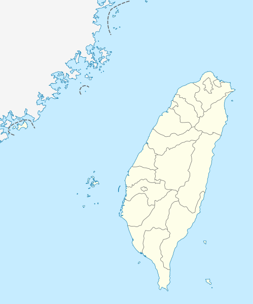
ಚಿತ್ರ:Taiwan location map.svg

Size of this PNG preview of this SVG file: ೪೯೯ × ೬೦೦ ಪಿಕ್ಸೆಲ್ಗಳು. ಇತರ ರೆಸಲ್ಯೂಶನ್ಗಳು: ೨೦೦ × ೨೪೦ ಪಿಕ್ಸೆಲ್ಗಳು | ೩೯೯ × ೪೮೦ ಪಿಕ್ಸೆಲ್ಗಳು | ೬೩೯ × ೭೬೮ ಪಿಕ್ಸೆಲ್ಗಳು | ೮೫೨ × ೧,೦೨೪ ಪಿಕ್ಸೆಲ್ಗಳು | ೧,೭೦೪ × ೨,೦೪೮ ಪಿಕ್ಸೆಲ್ಗಳು | ೧,೦೧೬ × ೧,೨೨೧ ಪಿಕ್ಸೆಲ್ಗಳು.
ಮೂಲ ಕಡತ (SVG ಫೈಲು, ಸುಮಾರಾಗಿ ೧,೦೧೬ × ೧,೨೨೧ ಚಿತ್ರಬಿಂದುಗಳು, ಫೈಲಿನ ಗಾತ್ರ: ೧೨೧ KB)
ಕಡತದ ಇತಿಹಾಸ
ದಿನ/ಕಾಲ ಒತ್ತಿದರೆ ಆ ಸಮಯದಲ್ಲಿ ಈ ಕಡತದ ವಸ್ತುಸ್ಥಿತಿ ತೋರುತ್ತದೆ.
| ದಿನ/ಕಾಲ | ಕಿರುನೋಟ | ಆಯಾಮಗಳು | ಬಳಕೆದಾರ | ಟಿಪ್ಪಣಿ | |
|---|---|---|---|---|---|
| ಪ್ರಸಕ್ತ | ೧೬:೪೫, ೨೨ ಆಗಸ್ಟ್ ೨೦೧೧ |  | ೧,೦೧೬ × ೧,೨೨೧ (೧೨೧ KB) | NordNordWest | minor corrections |
| ೧೭:೨೪, ೧೯ ಜುಲೈ ೨೦೧೧ |  | ೧,೦೧೬ × ೧,೨೨೨ (೧೬೬ KB) | Bencmq | Reverted to the version before dispute | |
| ೧೫:೧೬, ೧೯ ಜುಲೈ ೨೦೧೧ |  | ೧,೦೧೬ × ೧,೨೨೨ (೧೫೬ KB) | JOSH tw | You did not answer my query. If you would like to use this file on global website of wiki commons, you have to consider different concepts in order to keep it neutral | |
| ೧೨:೫೪, ೧೯ ಜುಲೈ ೨೦೧೧ |  | ೧,೦೧೬ × ೧,೨೨೧ (೧೨೧ KB) | NordNordWest | You can upload a new file if you want to, but don't change the status that is shown here. Next revert -> COM:V | |
| ೦೯:೫೦, ೧೯ ಜುಲೈ ೨೦೧೧ |  | ೧,೦೧೬ × ೧,೨೨೨ (೧೫೬ KB) | JOSH tw | If Kosovo as an UN unreconignized state can be shown on distinct appearance with Serbia, there is unreasonable to treat each other differently... especially P.R.China has never ruled Taiwan at any period of history | |
| ೦೩:೨೯, ೧೯ ಜುಲೈ ೨೦೧೧ |  | ೧,೦೧೬ × ೧,೨೨೧ (೧೨೧ KB) | NordNordWest | please don't change the political status shown in this map | |
| ೦೧:೫೩, ೧೯ ಜುಲೈ ೨೦೧೧ |  | ೧,೦೧೬ × ೧,೨೨೨ (೧೫೬ KB) | JOSH tw | Fixed map, political divisions have changed | |
| ೨೨:೨೪, ೩ ಜೂನ್ ೨೦೧೧ |  | ೧,೦೧೬ × ೧,೨೨೧ (೧೨೭ KB) | NordNordWest | please don't change the political status shown in this map | |
| ೧೮:೪೯, ೩ ಜೂನ್ ೨೦೧೧ |  | ೧,೦೧೬ × ೧,೨೨೨ (೧೫೬ KB) | Energiya | Fix the border of Matsu(Dongyin) and Kinmen (Dadan, Erdan, Wuqiu) see the page of Matsu Island and Kinmen. | |
| ೨೨:೪೯, ೨೮ ಡಿಸೆಂಬರ್ ೨೦೧೦ |  | ೧,೦೧೬ × ೧,೨೨೨ (೧೬೬ KB) | NordNordWest | wrong upd |
ಕಡತ ಬಳಕೆ
ಈ ಕೆಳಗಿನ ಪುಟವು ಈ ಚಿತ್ರಕ್ಕೆ ಸಂಪರ್ಕ ಹೊಂದಿದೆ:
ಜಾಗತಿಕ ಕಡತ ಉಪಯೋಗ
ಈ ಕಡತವನ್ನು ಕೆಳಗಿನ ಬೇರೆ ವಿಕಿಗಳೂ ಉಪಯೋಗಿಸುತ್ತಿವೆ:
- af.wikipedia.org ಮೇಲೆ ಬಳಕೆ
- an.wikipedia.org ಮೇಲೆ ಬಳಕೆ
- ar.wikipedia.org ಮೇಲೆ ಬಳಕೆ
- ast.wikipedia.org ಮೇಲೆ ಬಳಕೆ
- Taiwán
- Taipei 101
- Taipéi
- Nuevu Taipéi
- Keelung
- Taoyuan
- Taichung
- Muséu Nacional del Palaciu
- Islles Pescadores
- Módulu:Mapa de llocalización/datos/República de China
- Módulu:Mapa de llocalización/datos/Taiwán
- Módulu:Mapa de llocalización/datos/República de China/usu
- Aeropuertu Internacional de Taiwán Taoyuan
- Puertu de Kaohsiung
- Puertu de Taipéi
- az.wikipedia.org ಮೇಲೆ ಬಳಕೆ
- ba.wikipedia.org ಮೇಲೆ ಬಳಕೆ
- bcl.wikipedia.org ಮೇಲೆ ಬಳಕೆ
- be.wikipedia.org ಮೇಲೆ ಬಳಕೆ
- bg.wikipedia.org ಮೇಲೆ ಬಳಕೆ
- bn.wikipedia.org ಮೇಲೆ ಬಳಕೆ
- bs.wikipedia.org ಮೇಲೆ ಬಳಕೆ
- ceb.wikipedia.org ಮೇಲೆ ಬಳಕೆ
ಈ ಫೈಲ್ನ ಹೆಚ್ಚು ಜಾಗತಿಕ ಬಳಕೆಯನ್ನು ವೀಕ್ಷಿಸಿ.


