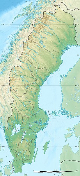
ಚಿತ್ರ:Sweden relief location map.jpg
Page contents not supported in other languages.
ವಿಕಿಪೀಡಿಯದಿಂದ, ಇದು ಮುಕ್ತ ಹಾಗೂ ಸ್ವತಂತ್ರ ವಿಶ್ವಕೋಶ

ಮೂಲ ಕಡತ(೮೪೨ × ೧,೮೩೭ ಚಿತ್ರಬಿಂದು, ಫೈಲಿನ ಗಾತ್ರ: ೫೪೧ KB, MIME ಪ್ರಕಾರ: image/jpeg)

ಸಾರಾಂಶ

Camera location೬೨° ೧೮′ ೦೦″ N, ೧೭° ೩೦′ ೦೦″ E Kartographer map based on OpenStreetMap.View this and other nearby images on: OpenStreetMapinfo
ವಿವರ
Deutsch: Relief Positionskarte von Schweden
English: Blank relief location map of Sweden
Français : Carte physique vierge de la Suède, destinée à la géolocalisation.

Scale: 1:3,708,000 (precision: 927 m)
Equirectangular projection, WGS84 datum

  • Standard meridian: 017° 30' E
  • Central parallel: 62° 18' N

Geographic limits of the map:

  • Top: 69° 30' N
  • Bottom: 55° 06' N
  • Left: 10° 24' E
  • Right: 24° 36' E
ದಿನಾಂಕ
ಆಕರ

Physical background map, rivers and lakes: own work

ಕರ್ತೃ Eric Gaba (Sting - fr:Sting) and NordNordWest
ಅನುಮತಿ
(ಈ ಕಡತವನ್ನು ಮರುಬಳಕೆ ಮಾಡಲಾಗುತ್ತಿದೆ)
Attribution and Share-Alike required
ಇತರೆ ಆವೃತ್ತಿಗಳು


Kartenwerkstatt
This map has been made or improved in the German Kartenwerkstatt (Map Lab). You can propose maps to improve as well.

ಪರವಾನಗಿ

I, the copyright holder of this work, hereby publish it under the following licenses:
GNU head GNU ಉಚಿತ ಡಾಕ್ಯುಮೆಂಟೇಶನ್ ಪರವಾನಗಿ, ಆವೃತ್ತಿಯ ನಿಯಮಗಳ ಅಡಿಯಲ್ಲಿ ಈ ಡಾಕ್ಯುಮೆಂಟ್ ಅನ್ನು ನಕಲಿಸಲು, ವಿತರಿಸಲು ಮತ್ತು/ಅಥವಾ ಮಾರ್ಪಡಿಸಲು ಅನುಮತಿಯನ್ನು ನೀಡಲಾಗಿದೆ. 1.2 ಅಥವಾ ಯಾವುದೇ ನಂತರದ ಆವೃತ್ತಿಯನ್ನು ಉಚಿತ ಸಾಫ್ಟ್‌ವೇರ್ ಫೌಂಡೇಶನ್ ಪ್ರಕಟಿಸಿದೆ; ಯಾವುದೇ ಅಸ್ಥಿರ ವಿಭಾಗಗಳಿಲ್ಲದೆ, ಮುಖ ಪಠ್ಯಗಳಿಲ್ಲ ಮತ್ತು ಹಿಂದಿನ ಕವರ್ ಪಠ್ಯಗಳಿಲ್ಲ. ಪರವಾನಗಿಯ ಪ್ರತಿಯನ್ನು GNU ಉಚಿತ ಡಾಕ್ಯುಮೆಂಟೇಶನ್ ಪರವಾನಗಿ ಎಂಬ ವಿಭಾಗದಲ್ಲಿ ಸೇರಿಸಲಾಗಿದೆ.
w:en:Creative Commons
ವೈಶಿಷ್ಟ್ಯ ಇರುವುದರಂತೆಯೇ ಹಂಚು
ಈ ಕಡತ ಕ್ರಿಯೇಟಿವ್ ಕಾಮನ್ಸ್ Attribution -Share Alike 3.0 Unported ಪರವಾನಗಿ ಹೊಂದಿದೆ.
ನೀವು ಮುಕ್ತ:
  • ಹಂಚಿಕೆಗೆ – ಕೆಲಸವನ್ನು ನಕಲು ಮಾಡಲು, ವಿತರಣೆ ಮತ್ತು ಸಾಗಿಸಲು
  • ರೀಮಿಕ್ಸ್ ಮಾಡಲು – ಕೆಲಸವನ್ನು ಬಳಸಿಕೊಳ್ಳಲು
ಈ ಕೆಳಗಿನ ಷರತ್ತುಗಳಲ್ಲಿ:
  • ವೈಶಿಷ್ಟ್ಯ – ನೀವು ಸೂಕ್ತವಾದ ಕ್ರೆಡಿಟ್ ನೀಡಬೇಕು, ಪರವಾನಗಿಗೆ ಲಿಂಕ್ ಅನ್ನು ಒದಗಿಸಬೇಕು ಮತ್ತು ಯಾವುದೇ ಬದಲಾವಣೆಗಳನ್ನು ಮಾಡಿದ್ದರೆ ಸೂಚಿಸಬೇಕು. ನೀವು ಯಾವುದೇ ಸಮಂಜಸವಾದ ರೀತಿಯಲ್ಲಿ ಮಾಡಬಹುದು, ಆದರೆ ಪರವಾನಗಿದಾರರು ನಿಮ್ಮನ್ನು ಅಥವಾ ನಿಮ್ಮ ಯಾವುದೇ ಬಳಕೆಯನ್ನು ಅನುಮೋದಿಸಿದಂತೆ ರೀತಿಯಲ್ಲಿ ಉಪಯೋಗಿಸಬಾರದು.
  • ಇರುವುದರಂತೆಯೇ ಹಂಚು – ನೀವು ರೀಮಿಕ್ಸ್ ಮಾಡಿದರೆ, ರೂಪಾಂತರಗೊಳಿಸಿದರೆ ಅಥವಾ ವಸ್ತುವಿನ ಮೇಲೆ ನಿರ್ಮಿಸಿದರೆ, ನಿಮ್ಮ ಕೊಡುಗೆಗಳನ್ನು ನೀವು ಮೂಲದಂತೆ ಅದೇ ಅಥವಾ ಹೊಂದಾಣಿಕೆಯ ಪರವಾನಗಿ ಅಡಿಯಲ್ಲಿ ವಿತರಿಸಬೇಕು.
ನಿಮ್ಮಿಚ್ಛೆಯ ಪರವಾನಗಿಯನ್ನು ನೀವು ಆರಿಸಿಕೊಳ್ಳಬಹುದು.

Captions

Add a one-line explanation of what this file represents

Items portrayed in this file

depicts ಇಂಗ್ಲಿಷ್

copyright status ಇಂಗ್ಲಿಷ್

copyrighted ಇಂಗ್ಲಿಷ್

ಆಗಸ್ಟ್ 2011

coordinates of the point of view ಇಂಗ್ಲಿಷ್

62°18'0.000"N, 17°30'0.000"E

ಕಡತದ ಇತಿಹಾಸ

ದಿನ/ಕಾಲ ಒತ್ತಿದರೆ ಆ ಸಮಯದಲ್ಲಿ ಈ ಕಡತದ ವಸ್ತುಸ್ಥಿತಿ ತೋರುತ್ತದೆ.

ದಿನ/ಕಾಲಕಿರುನೋಟಆಯಾಮಗಳುಬಳಕೆದಾರಟಿಪ್ಪಣಿ
ಪ್ರಸಕ್ತ೦೫:೨೨, ೧ ಅಕ್ಟೋಬರ್ ೨೦೧೭೦೫:೨೨, ೧ ಅಕ್ಟೋಬರ್ ೨೦೧೭ ವರೆಗಿನ ಆವೃತ್ತಿಯ ಕಿರುನೋಟ೮೪೨ × ೧,೮೩೭ (೫೪೧ KB)StingReverted to version as of 17:54, 5 August 2011 (UTC) - Negative: that would be the scale at the extreme top of the map which would introduce a reading error for the lower latitudes
೦೪:೫೯, ೧ ಅಕ್ಟೋಬರ್ ೨೦೧೭೦೪:೫೯, ೧ ಅಕ್ಟೋಬರ್ ೨೦೧೭ ವರೆಗಿನ ಆವೃತ್ತಿಯ ಕಿರುನೋಟ೮೪೨ × ೧,೮೩೭ (೭೪೩ KB)SlotaWojAfter adjusting the distance ruler.
೨೩:೨೪, ೫ ಆಗಸ್ಟ್ ೨೦೧೧೨೩:೨೪, ೫ ಆಗಸ್ಟ್ ೨೦೧೧ ವರೆಗಿನ ಆವೃತ್ತಿಯ ಕಿರುನೋಟ೮೪೨ × ೧,೮೩೭ (೫೪೧ KB)Sting== {{int:filedesc}} == {{Location|62|18|00|N|17|30|00|E|scale:7000000}} {{Information |Description= {{de|Relief Positionskarte von Schweden}} {{en|Blank relief location map of Sweden}} {{fr|Carte physique vierge de la [[:fr

ಈ ಕೆಳಗಿನ ಪುಟವು ಈ ಚಿತ್ರಕ್ಕೆ ಸಂಪರ್ಕ ಹೊಂದಿದೆ:

ಜಾಗತಿಕ ಕಡತ ಉಪಯೋಗ

ಈ ಕಡತವನ್ನು ಕೆಳಗಿನ ಬೇರೆ ವಿಕಿಗಳೂ ಉಪಯೋಗಿಸುತ್ತಿವೆ:

ಈ ಫೈಲ್‌ನ ಹೆಚ್ಚು ಜಾಗತಿಕ ಬಳಕೆಯನ್ನು ವೀಕ್ಷಿಸಿ.

ಮೇಲ್ದರ್ಜೆ ಮಾಹಿತಿ

"https://kn.wikipedia.org/wiki/ಚಿತ್ರ:Sweden_relief_location_map.jpg" ಇಂದ ಪಡೆಯಲ್ಪಟ್ಟಿದೆ