
ಚಿತ್ರ:Saxony-Anhalt relief location map.jpg

ಈ ಮುನ್ನೋಟ ಗಾತ್ರ:೫೦೯ × ೬೦೦ ಪಿಕ್ಸೆಲ್ಗಳು. ಇತರ ರೆಸಲ್ಯೂಶನ್ಗಳು: ೨೦೪ × ೨೪೦ ಪಿಕ್ಸೆಲ್ಗಳು | ೪೦೭ × ೪೮೦ ಪಿಕ್ಸೆಲ್ಗಳು | ೬೫೨ × ೭೬೮ ಪಿಕ್ಸೆಲ್ಗಳು | ೧,೨೭೩ × ೧,೫೦೦ ಪಿಕ್ಸೆಲ್ಗಳು.
ಮೂಲ ಕಡತ (೧,೨೭೩ × ೧,೫೦೦ ಚಿತ್ರಬಿಂದು, ಫೈಲಿನ ಗಾತ್ರ: ೬೯೧ KB, MIME ಪ್ರಕಾರ: image/jpeg)
ಈ ಫೈಲು ವಿಕಿಮೀಡಿಯ ಕಾಮನ್ಸ್ನಲ್ಲಿ ಇರುವುದು. ಅಲ್ಲಿನ ವಿವರಣೆ ಪುಟವನ್ನೇ ಕೆಳಗೆ ತೋರಿಸಲಾಗಿದೆ. ಕಾಮನ್ಸ್ ಕೃತಿಸ್ವಾಮ್ಯತೆಯಿಂದ ಮುಕ್ತ ಫೈಲುಗಳ ಒಂದು ಆಗರ. ಅಲ್ಲಿ ನೀವೂ ಸಹಕರಿಸಬಹುದು. |
ಸಾರಾಂಶ
| ವಿವರ |
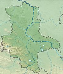
Deutsch: Physische Positionskarte Sachsen-Anhalt, Deutschland. Geographische Begrenzung der Karte:
English: Physical Location map Saxony-Anhalt, Germany. Geographic limits of the map:
|
| ದಿನಾಂಕ | |
| ಆಕರ |
ಸ್ವಂತ ಕೆಲಸ |
| ಕರ್ತೃ | Grundkarte TUBS, Relief Alexrk2 |
| ಇತರೆ ಆವೃತ್ತಿಗಳು |
Derivative works of this file: Regionalgruppen Megalithik Sachsen-Anhalt.png
|


|
This map has been made or improved in the German Kartenwerkstatt (Map Lab). You can propose maps to improve as well.
|
ಪರವಾನಗಿ
I, the copyright holder of this work, hereby publish it under the following license:
ಈ ಕಡತ ಕ್ರಿಯೇಟಿವ್ ಕಾಮನ್ಸ್ Attribution
-Share Alike 3.0 Unported ಪರವಾನಗಿ ಹೊಂದಿದೆ.
- ನೀವು ಮುಕ್ತ:
- ಹಂಚಿಕೆಗೆ – ಕೆಲಸವನ್ನು ನಕಲು ಮಾಡಲು, ವಿತರಣೆ ಮತ್ತು ಸಾಗಿಸಲು
- ರೀಮಿಕ್ಸ್ ಮಾಡಲು – ಕೆಲಸವನ್ನು ಬಳಸಿಕೊಳ್ಳಲು
- ಈ ಕೆಳಗಿನ ಷರತ್ತುಗಳಲ್ಲಿ:
- ವೈಶಿಷ್ಟ್ಯ – ನೀವು ಸೂಕ್ತವಾದ ಕ್ರೆಡಿಟ್ ನೀಡಬೇಕು, ಪರವಾನಗಿಗೆ ಲಿಂಕ್ ಅನ್ನು ಒದಗಿಸಬೇಕು ಮತ್ತು ಯಾವುದೇ ಬದಲಾವಣೆಗಳನ್ನು ಮಾಡಿದ್ದರೆ ಸೂಚಿಸಬೇಕು. ನೀವು ಯಾವುದೇ ಸಮಂಜಸವಾದ ರೀತಿಯಲ್ಲಿ ಮಾಡಬಹುದು, ಆದರೆ ಪರವಾನಗಿದಾರರು ನಿಮ್ಮನ್ನು ಅಥವಾ ನಿಮ್ಮ ಯಾವುದೇ ಬಳಕೆಯನ್ನು ಅನುಮೋದಿಸಿದಂತೆ ರೀತಿಯಲ್ಲಿ ಉಪಯೋಗಿಸಬಾರದು.
- ಇರುವುದರಂತೆಯೇ ಹಂಚು – ನೀವು ರೀಮಿಕ್ಸ್ ಮಾಡಿದರೆ, ರೂಪಾಂತರಗೊಳಿಸಿದರೆ ಅಥವಾ ವಸ್ತುವಿನ ಮೇಲೆ ನಿರ್ಮಿಸಿದರೆ, ನಿಮ್ಮ ಕೊಡುಗೆಗಳನ್ನು ನೀವು ಮೂಲದಂತೆ ಅದೇ ಅಥವಾ ಹೊಂದಾಣಿಕೆಯ ಪರವಾನಗಿ ಅಡಿಯಲ್ಲಿ ವಿತರಿಸಬೇಕು.
ಕಡತದ ಇತಿಹಾಸ
ದಿನ/ಕಾಲ ಒತ್ತಿದರೆ ಆ ಸಮಯದಲ್ಲಿ ಈ ಕಡತದ ವಸ್ತುಸ್ಥಿತಿ ತೋರುತ್ತದೆ.
| ದಿನ/ಕಾಲ | ಕಿರುನೋಟ | ಆಯಾಮಗಳು | ಬಳಕೆದಾರ | ಟಿಪ್ಪಣಿ | |
|---|---|---|---|---|---|
| ಪ್ರಸಕ್ತ | ೧೭:೨೫, ೨೭ ಸೆಪ್ಟೆಂಬರ್ ೨೦೦೯ | | ೧,೨೭೩ × ೧,೫೦೦ (೬೯೧ KB) | Alexrk2 | Farbskala angepasst |
| ೨೨:೪೬, ೨೨ ಸೆಪ್ಟೆಂಬರ್ ೨೦೦೯ |  | ೧,೨೭೩ × ೧,೫೦೦ (೭೧೬ KB) | Alexrk2 | Darstellungsreihenfolge Flüsse,Seen | |
| ೨೧:೩೭, ೨೨ ಸೆಪ್ಟೆಂಬರ್ ೨೦೦೯ |  | ೧,೨೭೩ × ೧,೫೦೦ (೭೧೬ KB) | Alexrk2 | Grenzen korr., Höhenfarbskala angepasst | |
| ೨೧:೫೮, ೧೭ ಸೆಪ್ಟೆಂಬರ್ ೨೦೦೯ |  | ೧,೨೭೨ × ೧,೫೦೦ (೭೫೪ KB) | Alexrk2 | == Summary == {{Information |Description= {{de|Physische Positionskarte Sachsen-Anhalt, Deutschland. Geographische Begrenzung der Karte:}} {{en|Physical Location map Saxony-Anhalt, Germany. Geographic limits |
ಕಡತ ಬಳಕೆ
ಈ ಕೆಳಗಿನ ಪುಟವು ಈ ಚಿತ್ರಕ್ಕೆ ಸಂಪರ್ಕ ಹೊಂದಿದೆ:
ಜಾಗತಿಕ ಕಡತ ಉಪಯೋಗ
ಈ ಕಡತವನ್ನು ಕೆಳಗಿನ ಬೇರೆ ವಿಕಿಗಳೂ ಉಪಯೋಗಿಸುತ್ತಿವೆ:
- ar.wikipedia.org ಮೇಲೆ ಬಳಕೆ
- ba.wikipedia.org ಮೇಲೆ ಬಳಕೆ
- bg.wikipedia.org ಮೇಲೆ ಬಳಕೆ
- Магдебург
- Хале (Зале)
- Айзлебен
- Теологичен университет Фриденсау
- Ашерслебен
- Мьокерн
- Магдебургски университет
- Айхенбарлебен
- Цербст
- Мерзебург
- Кведлинбург
- Шьонхаузен
- Шаблон:ПК Германия Саксония-Анхалт
- Ветин
- Витенберг
- Ландсберг (Саксония-Анхалт)
- Наумбург (Заале)
- Тангермюнде
- Арнебург
- Кьотен
- Нинбург (Саксония-Анхалт)
- Баленщет
- Халберщат
- Ермслебен
- Фалкенщайн (Харц)
- Вестдорф
- Пльотцкау
- Цайц
- Бернбург
- Вайсенфелс
- Харцгероде
- Безенщет
- Валхаузен
- Бьорделанд
- Бланкенбург (Саксония-Анхалт)
- Халденслебен
- Вербен (Саксония-Анхалт)
- Алслебен
- Мансфелд
- Акен
- Кверфурт
- Арнщайн
- Алщет
- Илзенбург
- Гозек
- Зангерхаузен
- Десау-Рослау
- Фрайбург (Саксония-Анхалт)
ಈ ಫೈಲ್ನ ಹೆಚ್ಚು ಜಾಗತಿಕ ಬಳಕೆಯನ್ನು ವೀಕ್ಷಿಸಿ.