
ಚಿತ್ರ:ReliefUSA map.gif
ಇದಕ್ಕಿಂತ ಹೆಚ್ಚಿನ ವಿವರವಾದ ನೋಟ ಇಲ್ಲ.
ReliefUSA_map.gif (೭೧೪ × ೪೯೬ ಚಿತ್ರಬಿಂದು, ಫೈಲಿನ ಗಾತ್ರ: ೨೨೮ KB, MIME ಪ್ರಕಾರ: image/gif)
ಈ ಫೈಲು ವಿಕಿಮೀಡಿಯ ಕಾಮನ್ಸ್ನಲ್ಲಿ ಇರುವುದು. ಅಲ್ಲಿನ ವಿವರಣೆ ಪುಟವನ್ನೇ ಕೆಳಗೆ ತೋರಿಸಲಾಗಿದೆ. ಕಾಮನ್ಸ್ ಕೃತಿಸ್ವಾಮ್ಯತೆಯಿಂದ ಮುಕ್ತ ಫೈಲುಗಳ ಒಂದು ಆಗರ. ಅಲ್ಲಿ ನೀವೂ ಸಹಕರಿಸಬಹುದು. |
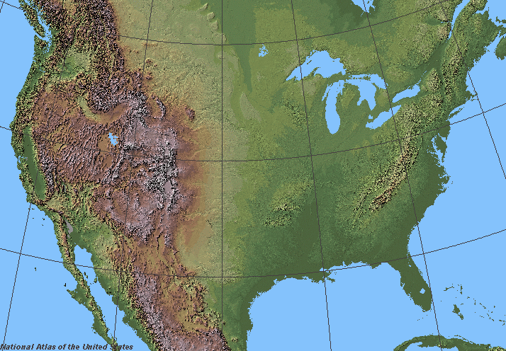
ಸಾರಾಂಶ
Shaded relief in the lower 48 states of the United States of America.
ಪರವಾನಗಿ
This map was obtained from an edition of the National Atlas of the United States. Like almost all works of the U.S. federal government, works from the National Atlas are in the public domain in the United States.
Online access: NationalAtlas.gov | 1970 print edition: Library of Congress, Perry-Castañeda Library
|
derivative works
Derivative works of this file:
ಕಡತದ ಇತಿಹಾಸ
ದಿನ/ಕಾಲ ಒತ್ತಿದರೆ ಆ ಸಮಯದಲ್ಲಿ ಈ ಕಡತದ ವಸ್ತುಸ್ಥಿತಿ ತೋರುತ್ತದೆ.
| ದಿನ/ಕಾಲ | ಕಿರುನೋಟ | ಆಯಾಮಗಳು | ಬಳಕೆದಾರ | ಟಿಪ್ಪಣಿ | |
|---|---|---|---|---|---|
| ಪ್ರಸಕ್ತ | ೧೧:೩೭, ೫ ಜೂನ್ ೨೦೦೬ | | ೭೧೪ × ೪೯೬ (೨೨೮ KB) | Urban~commonswiki | ==Description== Shaded relief in the lower 48 states of the United States of America. ==License== {{PD-USGov-Atlas}} |
ಕಡತ ಬಳಕೆ
ಈ ಫೈಲನ್ನು ಬಳಸುವ ಯಾವ ಪುಟಗಳೂ ಇಲ್ಲ.
ಜಾಗತಿಕ ಕಡತ ಉಪಯೋಗ
ಈ ಕಡತವನ್ನು ಕೆಳಗಿನ ಬೇರೆ ವಿಕಿಗಳೂ ಉಪಯೋಗಿಸುತ್ತಿವೆ:
- fr.wikipedia.org ಮೇಲೆ ಬಳಕೆ
- Wikipédia:Wikiconcours/mars 2008/Équipes
- Discussion Wikipédia:Wikiconcours/mars 2008/Équipes/Équipe 10
- Discussion Wikipédia:Wikiconcours/mars 2008/Équipes/Équipe 10/Mammoth
- Discussion Wikipédia:Wikiconcours/mars 2008/Équipes/Équipe 10/Denver
- Discussion Wikipédia:Wikiconcours/mars 2008/Équipes/Équipe 10/Baltimore
- Discussion Wikipédia:Wikiconcours/mars 2008/Équipes/Équipe 10/Glacier
- Discussion Wikipédia:Wikiconcours/mars 2008/Équipes/Équipe 10/Modèle
- Discussion Wikipédia:Wikiconcours/mars 2008/Équipes/Équipe 10/Louisville
- sco.wikipedia.org ಮೇಲೆ ಬಳಕೆ
- sl.wikipedia.org ಮೇಲೆ ಬಳಕೆ