
ಚಿತ್ರ:Nottinghamshire UK location map.svg

Size of this PNG preview of this SVG file: ೪೭೩ × ೫೯೯ ಪಿಕ್ಸೆಲ್ಗಳು. ಇತರ ರೆಸಲ್ಯೂಶನ್ಗಳು: ೧೮೯ × ೨೪೦ ಪಿಕ್ಸೆಲ್ಗಳು | ೩೭೯ × ೪೮೦ ಪಿಕ್ಸೆಲ್ಗಳು | ೬೦೬ × ೭೬೮ ಪಿಕ್ಸೆಲ್ಗಳು | ೮೦೮ × ೧,೦೨೪ ಪಿಕ್ಸೆಲ್ಗಳು | ೧,೬೧೬ × ೨,೦೪೮ ಪಿಕ್ಸೆಲ್ಗಳು | ೧,೦೩೦ × ೧,೩೦೫ ಪಿಕ್ಸೆಲ್ಗಳು.
ಮೂಲ ಕಡತ (SVG ಫೈಲು, ಸುಮಾರಾಗಿ ೧,೦೩೦ × ೧,೩೦೫ ಚಿತ್ರಬಿಂದುಗಳು, ಫೈಲಿನ ಗಾತ್ರ: ೧.೯೫ MB)
ಈ ಫೈಲು ವಿಕಿಮೀಡಿಯ ಕಾಮನ್ಸ್ನಲ್ಲಿ ಇರುವುದು. ಅಲ್ಲಿನ ವಿವರಣೆ ಪುಟವನ್ನೇ ಕೆಳಗೆ ತೋರಿಸಲಾಗಿದೆ. ಕಾಮನ್ಸ್ ಕೃತಿಸ್ವಾಮ್ಯತೆಯಿಂದ ಮುಕ್ತ ಫೈಲುಗಳ ಒಂದು ಆಗರ. ಅಲ್ಲಿ ನೀವೂ ಸಹಕರಿಸಬಹುದು. |
| ವಿವರ |
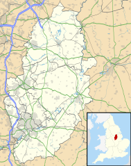
Map of Nottinghamshire, UK with the following information shown:
Equirectangular map projection on WGS 84 datum, with N/S stretched 165% Geographic limits:
|
| ದಿನಾಂಕ | |
| ಆಕರ |
|
| ಕರ್ತೃ | Nilfanion, created using Ordnance Survey data |
| ಅನುಮತಿ (ಈ ಕಡತವನ್ನು ಮರುಬಳಕೆ ಮಾಡಲಾಗುತ್ತಿದೆ) |
ಈ ಕಡತ ಕ್ರಿಯೇಟಿವ್ ಕಾಮನ್ಸ್ Attribution
-Share Alike 3.0 Unported ಪರವಾನಗಿ ಹೊಂದಿದೆ. ವೈಶಿಷ್ಟ್ಯ: Contains Ordnance Survey data © Crown copyright and database right
|
| ಇತರೆ ಆವೃತ್ತಿಗಳು | File:Nottinghamshire UK district map (blank).svg - Blank map |
.svg)
ಕಡತದ ಇತಿಹಾಸ
ದಿನ/ಕಾಲ ಒತ್ತಿದರೆ ಆ ಸಮಯದಲ್ಲಿ ಈ ಕಡತದ ವಸ್ತುಸ್ಥಿತಿ ತೋರುತ್ತದೆ.
| ದಿನ/ಕಾಲ | ಕಿರುನೋಟ | ಆಯಾಮಗಳು | ಬಳಕೆದಾರ | ಟಿಪ್ಪಣಿ | |
|---|---|---|---|---|---|
| ಪ್ರಸಕ್ತ | ೦೦:೩೯, ೨೭ ಸೆಪ್ಟೆಂಬರ್ ೨೦೧೦ | | ೧,೦೩೦ × ೧,೩೦೫ (೧.೯೫ MB) | Nilfanion | {{Information |Description=Map of Nottinghamshire, UK with the following information shown: *Administrative borders *Coastline, lakes and rivers *Roads and railways *Urban areas Equirectangular map projection on WGS 84 datum, with N |
ಕಡತ ಬಳಕೆ
ಈ ಕೆಳಗಿನ ಪುಟವು ಈ ಚಿತ್ರಕ್ಕೆ ಸಂಪರ್ಕ ಹೊಂದಿದೆ:
ಜಾಗತಿಕ ಕಡತ ಉಪಯೋಗ
ಈ ಕಡತವನ್ನು ಕೆಳಗಿನ ಬೇರೆ ವಿಕಿಗಳೂ ಉಪಯೋಗಿಸುತ್ತಿವೆ:
- ar.wikipedia.org ಮೇಲೆ ಬಳಕೆ
- bg.wikipedia.org ಮೇಲೆ ಬಳಕೆ
- br.wikipedia.org ಮೇಲೆ ಬಳಕೆ
- ceb.wikipedia.org ಮೇಲೆ ಬಳಕೆ
- en.wikipedia.org ಮೇಲೆ ಬಳಕೆ
- Newstead Abbey
- Beeston, Nottinghamshire
- Blyth, Nottinghamshire
- Worksop
- Newark-on-Trent
- Edwinstowe
- Nottingham Castle
- Gotham, Nottinghamshire
- Eastwood, Nottinghamshire
- Retford
- Ollerton
- Kimberley, Nottinghamshire
- The Park Estate
- Sutton Bonington
- Queen's Medical Centre
- Calverton, Nottinghamshire
- Wollaton Hall
- Hucknall
- Arnold, Nottinghamshire
- Bircotes
- Manton, Nottinghamshire
- Scrooby
- Carlton, Nottinghamshire
- Bingham, Nottinghamshire
- West Bridgford
- Sutton-in-Ashfield
- Gamston, Rushcliffe
- Cotgrave
- RAF Syerston
- Blidworth
- Lenton, Nottingham
- Kirkby-in-Ashfield
- Tollerton, Nottinghamshire
- Rampton Secure Hospital
- Holme Pierrepont
- Zouch
- Nottingham station
- Mansfield Woodhouse
- Toton
- Redhill, Nottinghamshire
- Aslockton
- Clumber Park
- Spion Kop, Nottinghamshire
- Chilwell
- Radford, Nottingham
ಈ ಫೈಲ್ನ ಹೆಚ್ಚು ಜಾಗತಿಕ ಬಳಕೆಯನ್ನು ವೀಕ್ಷಿಸಿ.