
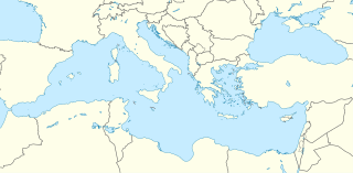
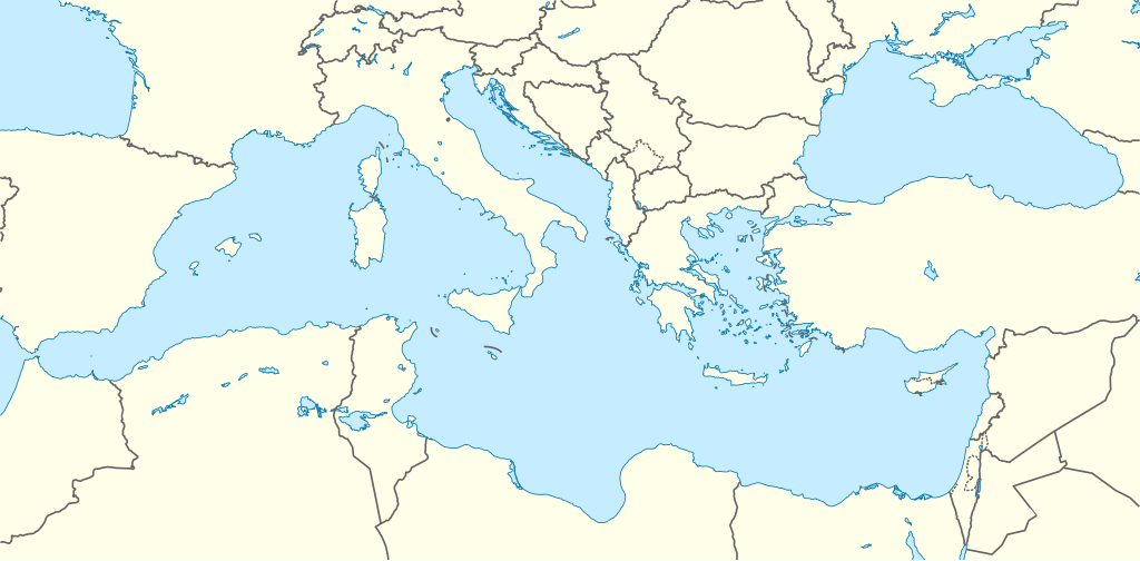
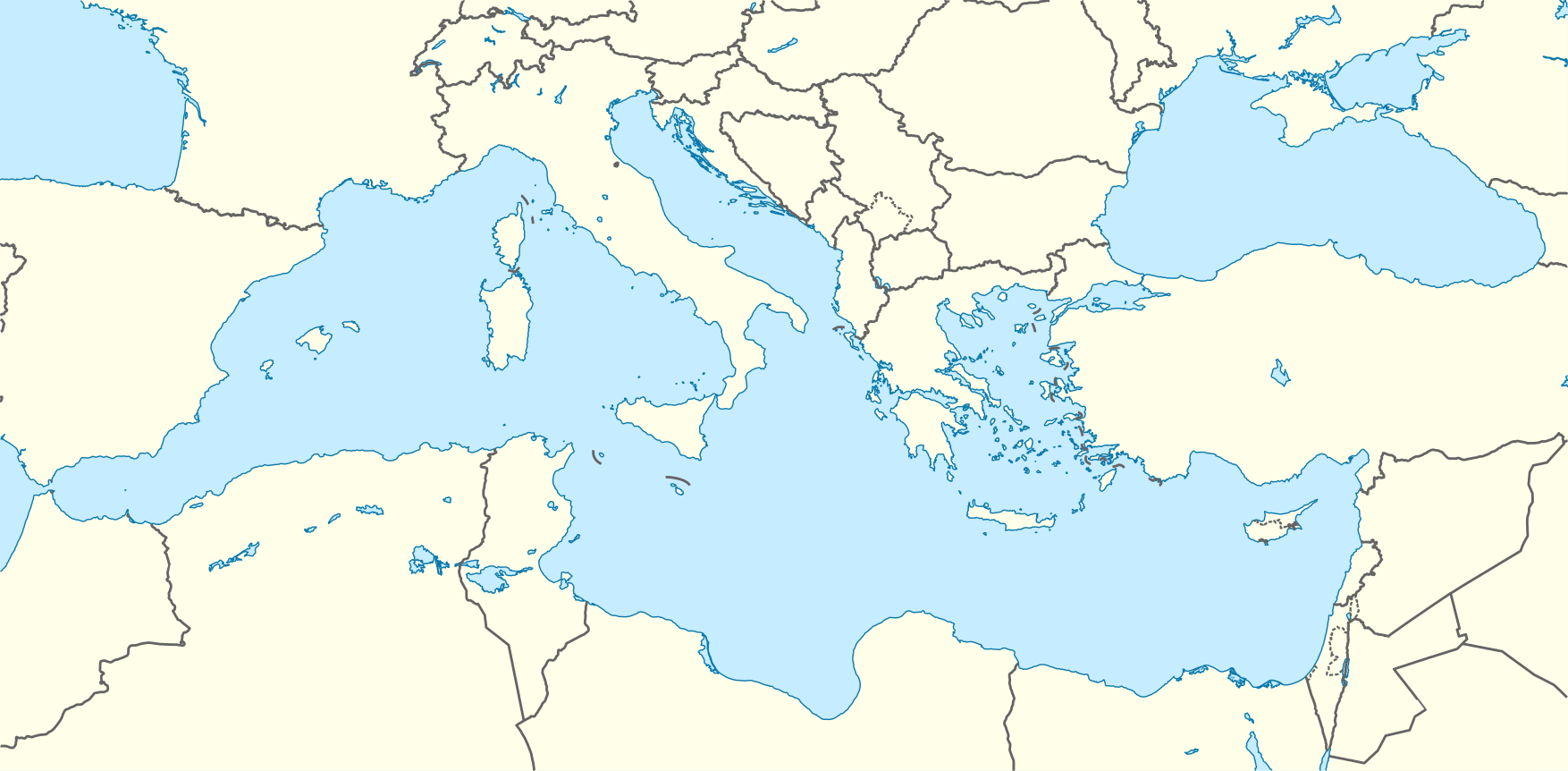
ಚಿತ್ರ:Mediterranean Sea location map.svg

ಮೂಲ ಕಡತ (SVG ಫೈಲು, ಸುಮಾರಾಗಿ ೧,೭೫೪ × ೮೬೨ ಚಿತ್ರಬಿಂದುಗಳು, ಫೈಲಿನ ಗಾತ್ರ: ೧.೧೯ MB)
ಈ ಫೈಲು ವಿಕಿಮೀಡಿಯ ಕಾಮನ್ಸ್ನಲ್ಲಿ ಇರುವುದು. ಅಲ್ಲಿನ ವಿವರಣೆ ಪುಟವನ್ನೇ ಕೆಳಗೆ ತೋರಿಸಲಾಗಿದೆ. ಕಾಮನ್ಸ್ ಕೃತಿಸ್ವಾಮ್ಯತೆಯಿಂದ ಮುಕ್ತ ಫೈಲುಗಳ ಒಂದು ಆಗರ. ಅಲ್ಲಿ ನೀವೂ ಸಹಕರಿಸಬಹುದು. |
ಸಾರಾಂಶ
| ವಿವರ |
Deutsch: Positionskarte des Mittelmeers
Quadratische Plattkarte, N-S-Streckung 128 %. Geographische Begrenzung der Karte:
English: Location map of the Mediterranean Sea
Equirectangular projection, N/S stretching 128 %. Geographic limits of the map:
|
|
| ದಿನಾಂಕ | ||
| ಆಕರ | ಸ್ವಂತ ಕೆಲಸ using World Data Base II data | |
| ಕರ್ತೃ | NordNordWest | |
| ಅನುಮತಿ (ಈ ಕಡತವನ್ನು ಮರುಬಳಕೆ ಮಾಡಲಾಗುತ್ತಿದೆ) |
This file is licensed under the Creative Commons Attribution-Share Alike 3.0 Germany license.
 ಈ ಕಡತ ಕ್ರಿಯೇಟಿವ್ ಕಾಮನ್ಸ್ Attribution
-Share Alike 3.0 Unported ಪರವಾನಗಿ ಹೊಂದಿದೆ.
|
|
| ಇತರೆ ಆವೃತ್ತಿಗಳು |
Derivative works of this file: |

.svg)

|
This map has been made or improved in the German Kartenwerkstatt (Map Lab). You can propose maps to improve as well.
|
ಕಡತದ ಇತಿಹಾಸ
ದಿನ/ಕಾಲ ಒತ್ತಿದರೆ ಆ ಸಮಯದಲ್ಲಿ ಈ ಕಡತದ ವಸ್ತುಸ್ಥಿತಿ ತೋರುತ್ತದೆ.
| ದಿನ/ಕಾಲ | ಕಿರುನೋಟ | ಆಯಾಮಗಳು | ಬಳಕೆದಾರ | ಟಿಪ್ಪಣಿ | |
|---|---|---|---|---|---|
| ಪ್ರಸಕ್ತ | ೧೪:೨೮, ೮ ಸೆಪ್ಟೆಂಬರ್ ೨೦೧೦ | | ೧,೭೫೪ × ೮೬೨ (೧.೧೯ MB) | NordNordWest | =={{int:filedesc}}== {{Information |Description= {{de|Positionskarte des Mittelmeers}} Quadratische Plattkarte, N-S-Streckung 128 %. Geographische Begrenzung der Karte: * N: 48.0° N * S: 29.0° N * W: 7.0° W * O: 42.5° O {{en|Locatio |
ಕಡತ ಬಳಕೆ
ಈ ಕೆಳಗಿನ ಪುಟವು ಈ ಚಿತ್ರಕ್ಕೆ ಸಂಪರ್ಕ ಹೊಂದಿದೆ:
ಜಾಗತಿಕ ಕಡತ ಉಪಯೋಗ
ಈ ಕಡತವನ್ನು ಕೆಳಗಿನ ಬೇರೆ ವಿಕಿಗಳೂ ಉಪಯೋಗಿಸುತ್ತಿವೆ:
- ar.wikipedia.org ಮೇಲೆ ಬಳಕೆ
- قائمة الدول المتوسطية
- قالب:خريطة مواقع البحر المتوسط
- ويكيبيديا:بوابة اليوم المختارة/الأرشيف
- ويكيبيديا:بوابة اليوم المختارة/يناير 2016
- قالب:بوابة اليوم المختارة/2016-01-03
- قالب:بوابة اليوم المختارة/2016-01-04
- ويكيبيديا:بوابة اليوم المختارة/مايو 2016
- قالب:بوابة اليوم المختارة/2016-05-13
- قالب:بوابة اليوم المختارة/2016-09-01
- ويكيبيديا:بوابة اليوم المختارة/سبتمبر 2016
- ويكيبيديا:بوابة اليوم المختارة/ديسمبر 2016
- قالب:بوابة اليوم المختارة/2016-12-27
- ويكيبيديا:بوابة اليوم المختارة/أبريل 2017
- قالب:بوابة اليوم المختارة/2017-04-23
- ويكيبيديا:بوابة اليوم المختارة/أغسطس 2017
- قالب:بوابة اليوم المختارة/2017-08-19
- ويكيبيديا:بوابة اليوم المختارة/ديسمبر 2017
- قالب:بوابة اليوم المختارة/2017-12-03
- ويكيبيديا:بوابة اليوم المختارة/يونيو 2018
- قالب:بوابة اليوم المختارة/2018-06-02
- ويكيبيديا:بوابة اليوم المختارة/أغسطس 2018
- قالب:بوابة اليوم المختارة/2018-08-15
- ويكيبيديا:بوابة اليوم المختارة/يناير 2019
- قالب:بوابة اليوم المختارة/2019-01-05
- ويكيبيديا:بوابة اليوم المختارة/مايو 2019
- قالب:بوابة اليوم المختارة/2019-05-16
- ويكيبيديا:بوابة اليوم المختارة/أكتوبر 2019
- قالب:بوابة اليوم المختارة/2019-10-03
- ويكيبيديا:بوابة اليوم المختارة/فبراير 2020
- قالب:بوابة اليوم المختارة/2020-02-05
- القوات الجوية السادسة عشرة
- ويكيبيديا:بوابة اليوم المختارة/يونيو 2020
- قالب:بوابة اليوم المختارة/2020-06-06
- ويكيبيديا:بوابة اليوم المختارة/أكتوبر 2020
- قالب:بوابة اليوم المختارة/2020-10-04
- ويكيبيديا:بوابة اليوم المختارة/فبراير 2021
- قالب:بوابة اليوم المختارة/2021-02-08
- ويكيبيديا:بوابة اليوم المختارة/يونيو 2021
- قالب:بوابة اليوم المختارة/2021-06-14
- ويكيبيديا:بوابة اليوم المختارة/أكتوبر 2021
- قالب:بوابة اليوم المختارة/2021-10-19
- ويكيبيديا:بوابة اليوم المختارة/فبراير 2022
- قالب:بوابة اليوم المختارة/2022-02-22
- ويكيبيديا:بوابة اليوم المختارة/يونيو 2022
- قالب:بوابة اليوم المختارة/2022-06-30
- ويكيبيديا:بوابة اليوم المختارة/نوفمبر 2022
- قالب:بوابة اليوم المختارة/2022-11-04
- ويكيبيديا:بوابة اليوم المختارة/مارس 2023
- قالب:بوابة اليوم المختارة/2023-03-12
- ويكيبيديا:بوابة اليوم المختارة/يوليو 2023
ಈ ಫೈಲ್ನ ಹೆಚ್ಚು ಜಾಗತಿಕ ಬಳಕೆಯನ್ನು ವೀಕ್ಷಿಸಿ.