
ಚಿತ್ರ:Map of Nevada highlighting Humboldt County.svg

Size of this PNG preview of this SVG file: ೪೦೫ × ೫೯೯ ಪಿಕ್ಸೆಲ್ಗಳು. ಇತರ ರೆಸಲ್ಯೂಶನ್ಗಳು: ೧೬೨ × ೨೪೦ ಪಿಕ್ಸೆಲ್ಗಳು | ೩೨೪ × ೪೮೦ ಪಿಕ್ಸೆಲ್ಗಳು | ೫೧೯ × ೭೬೮ ಪಿಕ್ಸೆಲ್ಗಳು | ೬೯೨ × ೧,೦೨೪ ಪಿಕ್ಸೆಲ್ಗಳು | ೧,೩೮೫ × ೨,೦೪೮ ಪಿಕ್ಸೆಲ್ಗಳು | ೫,೨೫೭ × ೭,೭೭೫ ಪಿಕ್ಸೆಲ್ಗಳು.
ಮೂಲ ಕಡತ (SVG ಫೈಲು, ಸುಮಾರಾಗಿ ೫,೨೫೭ × ೭,೭೭೫ ಚಿತ್ರಬಿಂದುಗಳು, ಫೈಲಿನ ಗಾತ್ರ: ೩೩ KB)
ಈ ಫೈಲು ವಿಕಿಮೀಡಿಯ ಕಾಮನ್ಸ್ನಲ್ಲಿ ಇರುವುದು. ಅಲ್ಲಿನ ವಿವರಣೆ ಪುಟವನ್ನೇ ಕೆಳಗೆ ತೋರಿಸಲಾಗಿದೆ. ಕಾಮನ್ಸ್ ಕೃತಿಸ್ವಾಮ್ಯತೆಯಿಂದ ಮುಕ್ತ ಫೈಲುಗಳ ಒಂದು ಆಗರ. ಅಲ್ಲಿ ನೀವೂ ಸಹಕರಿಸಬಹುದು. |
ಸಾರಾಂಶ
| ವಿವರ |
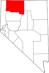
English: This is a locator map showing Humboldt County in Nevada. For more information, see Commons:United States county locator maps. |
| ದಿನಾಂಕ | |
| ಆಕರ |
ಸ್ವಂತ ಕೆಲಸ: English: The maps use data from nationalatlas.gov, specifically countyp020.tar.gz on the Raw Data Download page. The maps also use state outline data from statesp020.tar.gz. The Florida maps use hydrogm020.tar.gz to display Lake Okeechobee. |
| ಕರ್ತೃ | David Benbennick |
ಪರವಾನಗಿ
| I, the copyright holder of this work, release this work into the public domain. This applies worldwide. In some countries this may not be legally possible; if so: I grant anyone the right to use this work for any purpose, without any conditions, unless such conditions are required by law. |
ಕಡತದ ಇತಿಹಾಸ
ದಿನ/ಕಾಲ ಒತ್ತಿದರೆ ಆ ಸಮಯದಲ್ಲಿ ಈ ಕಡತದ ವಸ್ತುಸ್ಥಿತಿ ತೋರುತ್ತದೆ.
| ದಿನ/ಕಾಲ | ಕಿರುನೋಟ | ಆಯಾಮಗಳು | ಬಳಕೆದಾರ | ಟಿಪ್ಪಣಿ | |
|---|---|---|---|---|---|
| ಪ್ರಸಕ್ತ | ೨೦:೩೦, ೧೨ ಫೆಬ್ರವರಿ ೨೦೦೬ | | ೫,೨೫೭ × ೭,೭೭೫ (೩೩ KB) | David Benbennick | {{subst:User:Dbenbenn/clm|county=Humboldt County|state=Nevada|type=county}} |
ಕಡತ ಬಳಕೆ
ಈ ಫೈಲನ್ನು ಬಳಸುವ ಯಾವ ಪುಟಗಳೂ ಇಲ್ಲ.
ಜಾಗತಿಕ ಕಡತ ಉಪಯೋಗ
ಈ ಕಡತವನ್ನು ಕೆಳಗಿನ ಬೇರೆ ವಿಕಿಗಳೂ ಉಪಯೋಗಿಸುತ್ತಿವೆ:
- ar.wikipedia.org ಮೇಲೆ ಬಳಕೆ
- azb.wikipedia.org ಮೇಲೆ ಬಳಕೆ
- bg.wikipedia.org ಮೇಲೆ ಬಳಕೆ
- bpy.wikipedia.org ಮೇಲೆ ಬಳಕೆ
- ca.wikipedia.org ಮೇಲೆ ಬಳಕೆ
- ceb.wikipedia.org ಮೇಲೆ ಬಳಕೆ
- ce.wikipedia.org ಮೇಲೆ ಬಳಕೆ
- cs.wikipedia.org ಮೇಲೆ ಬಳಕೆ
- cy.wikipedia.org ಮೇಲೆ ಬಳಕೆ
- de.wikipedia.org ಮೇಲೆ ಬಳಕೆ
- en.wikipedia.org ಮೇಲೆ ಬಳಕೆ
- List of counties in Nevada
- Humboldt County, Nevada
- McDermitt, Nevada and Oregon
- Winnemucca, Nevada
- Paradise Valley, Nevada
- Golconda, Nevada
- Denio, Nevada
- Orovada, Nevada
- Valmy, Nevada
- Stone House, Nevada
- Template:Humboldt County, Nevada
- User:Nyttend/County templates/NV
- Humboldt County Courthouse (Nevada)
- Sulphur, Nevada
- Category:Populated places in Humboldt County, Nevada
- Fort McDermitt, Nevada
- Fort McDermitt Paiute and Shoshone Tribe
- Hardin City, Nevada
- Jungo, Nevada
- Daveytown, Nevada
- Tule, Nevada
- Amos, Nevada
- National, Nevada
ಈ ಫೈಲ್ನ ಹೆಚ್ಚು ಜಾಗತಿಕ ಬಳಕೆಯನ್ನು ವೀಕ್ಷಿಸಿ.