
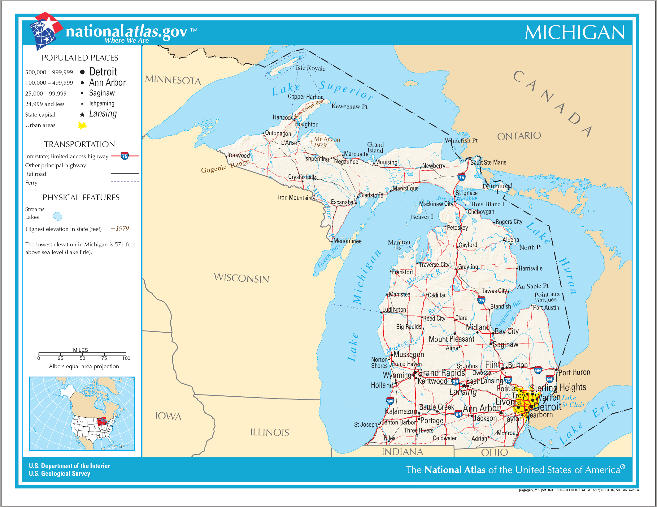
ಚಿತ್ರ:Map of Michigan NA.png
ಈ ಮುನ್ನೋಟ ಗಾತ್ರ:೭೭೬ × ೬೦೦ ಪಿಕ್ಸೆಲ್ಗಳು. ಇತರ ರೆಸಲ್ಯೂಶನ್ಗಳು: ೩೧೧ × ೨೪೦ ಪಿಕ್ಸೆಲ್ಗಳು | ೬೨೧ × ೪೮೦ ಪಿಕ್ಸೆಲ್ಗಳು | ೯೯೪ × ೭೬೮ ಪಿಕ್ಸೆಲ್ಗಳು | ೧,೨೮೦ × ೯೮೯ ಪಿಕ್ಸೆಲ್ಗಳು | ೨,೧೨೨ × ೧,೬೪೦ ಪಿಕ್ಸೆಲ್ಗಳು.
ಮೂಲ ಕಡತ (೨,೧೨೨ × ೧,೬೪೦ ಚಿತ್ರಬಿಂದು, ಫೈಲಿನ ಗಾತ್ರ: ೧.೨೧ MB, MIME ಪ್ರಕಾರ: image/png)
ಈ ಫೈಲು ವಿಕಿಮೀಡಿಯ ಕಾಮನ್ಸ್ನಲ್ಲಿ ಇರುವುದು. ಅಲ್ಲಿನ ವಿವರಣೆ ಪುಟವನ್ನೇ ಕೆಳಗೆ ತೋರಿಸಲಾಗಿದೆ. ಕಾಮನ್ಸ್ ಕೃತಿಸ್ವಾಮ್ಯತೆಯಿಂದ ಮುಕ್ತ ಫೈಲುಗಳ ಒಂದು ಆಗರ. ಅಲ್ಲಿ ನೀವೂ ಸಹಕರಿಸಬಹುದು. |
ಸಾರಾಂಶ
| ವಿವರ |
English: Map of Michigan |
| ದಿನಾಂಕ | |
| ಆಕರ | National Atlas |
| ಕರ್ತೃ |
ಪರವಾನಗಿ
This map was obtained from an edition of the National Atlas of the United States. Like almost all works of the U.S. federal government, works from the National Atlas are in the public domain in the United States.
Online access: NationalAtlas.gov | 1970 print edition: Library of Congress, Perry-Castañeda Library
|
ಕಡತದ ಇತಿಹಾಸ
ದಿನ/ಕಾಲ ಒತ್ತಿದರೆ ಆ ಸಮಯದಲ್ಲಿ ಈ ಕಡತದ ವಸ್ತುಸ್ಥಿತಿ ತೋರುತ್ತದೆ.
| ದಿನ/ಕಾಲ | ಕಿರುನೋಟ | ಆಯಾಮಗಳು | ಬಳಕೆದಾರ | ಟಿಪ್ಪಣಿ | |
|---|---|---|---|---|---|
| ಪ್ರಸಕ್ತ | ೦೨:೩೯, ೧೫ ಆಗಸ್ಟ್ ೨೦೦೬ | | ೨,೧೨೨ × ೧,೬೪೦ (೧.೨೧ MB) | Huebi~commonswiki | {{Information| |Description=Map of Michigan |Source=[http://www.nationalatlas.gov National Atlas] }} Category:Maps of the United States Category:Maps of Michigan {{PD-USGov-Atlas}} |
ಕಡತ ಬಳಕೆ
ಈ ಕೆಳಗಿನ 2 ಪುಟಗಳು ಈ ಚಿತ್ರಕ್ಕೆ ಸಂಪರ್ಕ ಹೊಂದಿವೆ:
ಜಾಗತಿಕ ಕಡತ ಉಪಯೋಗ
ಈ ಕಡತವನ್ನು ಕೆಳಗಿನ ಬೇರೆ ವಿಕಿಗಳೂ ಉಪಯೋಗಿಸುತ್ತಿವೆ:
- ca.wikipedia.org ಮೇಲೆ ಬಳಕೆ
- de.wikipedia.org ಮೇಲೆ ಬಳಕೆ
- en.wikipedia.org ಮೇಲೆ ಬಳಕೆ
- fo.wikipedia.org ಮೇಲೆ ಬಳಕೆ
- hr.wiktionary.org ಮೇಲೆ ಬಳಕೆ
- hsb.wikipedia.org ಮೇಲೆ ಬಳಕೆ
- ilo.wikipedia.org ಮೇಲೆ ಬಳಕೆ
- incubator.wikimedia.org ಮೇಲೆ ಬಳಕೆ
- it.wikipedia.org ಮೇಲೆ ಬಳಕೆ
- lij.wikipedia.org ಮೇಲೆ ಬಳಕೆ
- ru.wikivoyage.org ಮೇಲೆ ಬಳಕೆ
- simple.wikipedia.org ಮೇಲೆ ಬಳಕೆ
- si.wikipedia.org ಮೇಲೆ ಬಳಕೆ
- sl.wikipedia.org ಮೇಲೆ ಬಳಕೆ
- sw.wikipedia.org ಮೇಲೆ ಬಳಕೆ
- zea.wikipedia.org ಮೇಲೆ ಬಳಕೆ