
ಚಿತ್ರ:Location map of Union County, New Jersey.svg

Size of this PNG preview of this SVG file: ೭೦೦ × ೬೦೦ ಪಿಕ್ಸೆಲ್ಗಳು. ಇತರ ರೆಸಲ್ಯೂಶನ್ಗಳು: ೨೮೦ × ೨೪೦ ಪಿಕ್ಸೆಲ್ಗಳು | ೫೬೦ × ೪೮೦ ಪಿಕ್ಸೆಲ್ಗಳು | ೮೯೬ × ೭೬೮ ಪಿಕ್ಸೆಲ್ಗಳು | ೧,೧೯೫ × ೧,೦೨೪ ಪಿಕ್ಸೆಲ್ಗಳು | ೨,೩೮೯ × ೨,೦೪೮ ಪಿಕ್ಸೆಲ್ಗಳು.
ಮೂಲ ಕಡತ (SVG ಫೈಲು, ಸುಮಾರಾಗಿ ೮೯೬ × ೭೬೮ ಚಿತ್ರಬಿಂದುಗಳು, ಫೈಲಿನ ಗಾತ್ರ: ೩೯೦ KB)
ಈ ಫೈಲು ವಿಕಿಮೀಡಿಯ ಕಾಮನ್ಸ್ನಲ್ಲಿ ಇರುವುದು. ಅಲ್ಲಿನ ವಿವರಣೆ ಪುಟವನ್ನೇ ಕೆಳಗೆ ತೋರಿಸಲಾಗಿದೆ. ಕಾಮನ್ಸ್ ಕೃತಿಸ್ವಾಮ್ಯತೆಯಿಂದ ಮುಕ್ತ ಫೈಲುಗಳ ಒಂದು ಆಗರ. ಅಲ್ಲಿ ನೀವೂ ಸಹಕರಿಸಬಹುದು. |
ಸಾರಾಂಶ
| ವಿವರ |
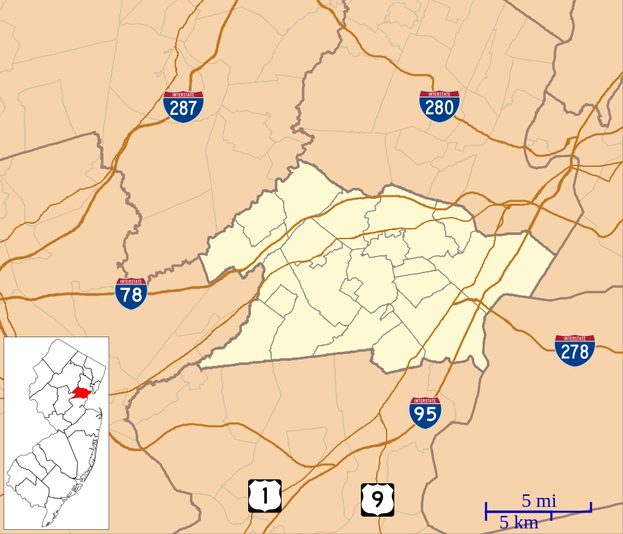
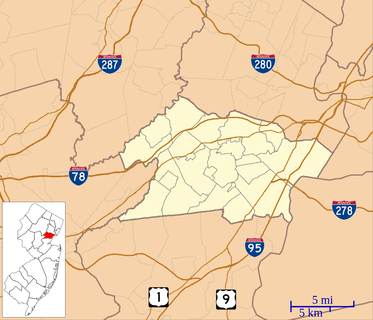
English: This is a map of Union County, New Jersey, USA which includes incorporated settlements, township borders, and major highways. |
| ದಿನಾಂಕ | |
| ಆಕರ | My own work, using custom-written MapScript applications with United States Census Bureau data |
| ಕರ್ತೃ | Omnedon |
ಪರವಾನಗಿ
| I, the copyright holder of this work, release this work into the public domain. This applies worldwide. In some countries this may not be legally possible; if so: I grant anyone the right to use this work for any purpose, without any conditions, unless such conditions are required by law. |
ಕಡತದ ಇತಿಹಾಸ
ದಿನ/ಕಾಲ ಒತ್ತಿದರೆ ಆ ಸಮಯದಲ್ಲಿ ಈ ಕಡತದ ವಸ್ತುಸ್ಥಿತಿ ತೋರುತ್ತದೆ.
| ದಿನ/ಕಾಲ | ಕಿರುನೋಟ | ಆಯಾಮಗಳು | ಬಳಕೆದಾರ | ಟಿಪ್ಪಣಿ | |
|---|---|---|---|---|---|
| ಪ್ರಸಕ್ತ | ೦೨:೧೯, ೨೨ ಸೆಪ್ಟೆಂಬರ್ ೨೦೧೨ | | ೮೯೬ × ೭೬೮ (೩೯೦ KB) | Omnedon | == {{int:filedesc}} == {{Information |Description={{en|This is a map of Union County, New Jersey, USA which includes incorporated settlements, township borders, and major highways.}} |Source=My own work, using custom-wri... |
ಕಡತ ಬಳಕೆ
ಈ ಕೆಳಗಿನ ಪುಟವು ಈ ಚಿತ್ರಕ್ಕೆ ಸಂಪರ್ಕ ಹೊಂದಿದೆ:
ಜಾಗತಿಕ ಕಡತ ಉಪಯೋಗ
ಈ ಕಡತವನ್ನು ಕೆಳಗಿನ ಬೇರೆ ವಿಕಿಗಳೂ ಉಪಯೋಗಿಸುತ್ತಿವೆ:
- ar.wikipedia.org ಮೇಲೆ ಬಳಕೆ
- azb.wikipedia.org ಮೇಲೆ ಬಳಕೆ
- ceb.wikipedia.org ಮೇಲೆ ಬಳಕೆ
- en.wikipedia.org ಮೇಲೆ ಬಳಕೆ
- Plainfield, New Jersey
- Cranford, New Jersey
- Murray Hill, New Jersey
- Berkeley Heights, New Jersey
- Clark, New Jersey
- Elizabeth, New Jersey
- Fanwood, New Jersey
- Garwood, New Jersey
- Hillside, New Jersey
- Kenilworth, New Jersey
- Linden, New Jersey
- Mountainside, New Jersey
- New Providence, New Jersey
- Rahway, New Jersey
- Roselle, New Jersey
- Roselle Park, New Jersey
- Scotch Plains, New Jersey
- Springfield Township, Union County, New Jersey
- Summit, New Jersey
- Union Township, Union County, New Jersey
- Westfield, New Jersey
- Winfield Township, New Jersey
- Kean University
- Baltusrol Golf Club
- Bayway Refinery
- Reeves-Reed Arboretum
- Evergreen Cemetery (Hillside, New Jersey)
- Fanwood station
- Netherwood station
- Free Acres, New Jersey
- Vauxhall, New Jersey
- Twin Maples
- St. John's Episcopal Church (Elizabeth, New Jersey)
- Boxwood Hall
- Liberty Hall (New Jersey)
- Caldwell Parsonage
- Connecticut Farms Presbyterian Church
- Feltville Historic District
- 1993 U.S. Open (golf)
- 1980 U.S. Open (golf)
- 1967 U.S. Open (golf)
- 1954 U.S. Open (golf)
ಈ ಫೈಲ್ನ ಹೆಚ್ಚು ಜಾಗತಿಕ ಬಳಕೆಯನ್ನು ವೀಕ್ಷಿಸಿ.