
ಚಿತ್ರ:Location map of Monmouth County, New Jersey.svg

Size of this PNG preview of this SVG file: ೭೦೦ × ೬೦೦ ಪಿಕ್ಸೆಲ್ಗಳು. ಇತರ ರೆಸಲ್ಯೂಶನ್ಗಳು: ೨೮೦ × ೨೪೦ ಪಿಕ್ಸೆಲ್ಗಳು | ೫೬೦ × ೪೮೦ ಪಿಕ್ಸೆಲ್ಗಳು | ೮೯೬ × ೭೬೮ ಪಿಕ್ಸೆಲ್ಗಳು | ೧,೧೯೫ × ೧,೦೨೪ ಪಿಕ್ಸೆಲ್ಗಳು | ೨,೩೮೯ × ೨,೦೪೮ ಪಿಕ್ಸೆಲ್ಗಳು.
ಮೂಲ ಕಡತ (SVG ಫೈಲು, ಸುಮಾರಾಗಿ ೮೯೬ × ೭೬೮ ಚಿತ್ರಬಿಂದುಗಳು, ಫೈಲಿನ ಗಾತ್ರ: ೧.೦೧ MB)
ಈ ಫೈಲು ವಿಕಿಮೀಡಿಯ ಕಾಮನ್ಸ್ನಲ್ಲಿ ಇರುವುದು. ಅಲ್ಲಿನ ವಿವರಣೆ ಪುಟವನ್ನೇ ಕೆಳಗೆ ತೋರಿಸಲಾಗಿದೆ. ಕಾಮನ್ಸ್ ಕೃತಿಸ್ವಾಮ್ಯತೆಯಿಂದ ಮುಕ್ತ ಫೈಲುಗಳ ಒಂದು ಆಗರ. ಅಲ್ಲಿ ನೀವೂ ಸಹಕರಿಸಬಹುದು. |
ಸಾರಾಂಶ
| ವಿವರ |
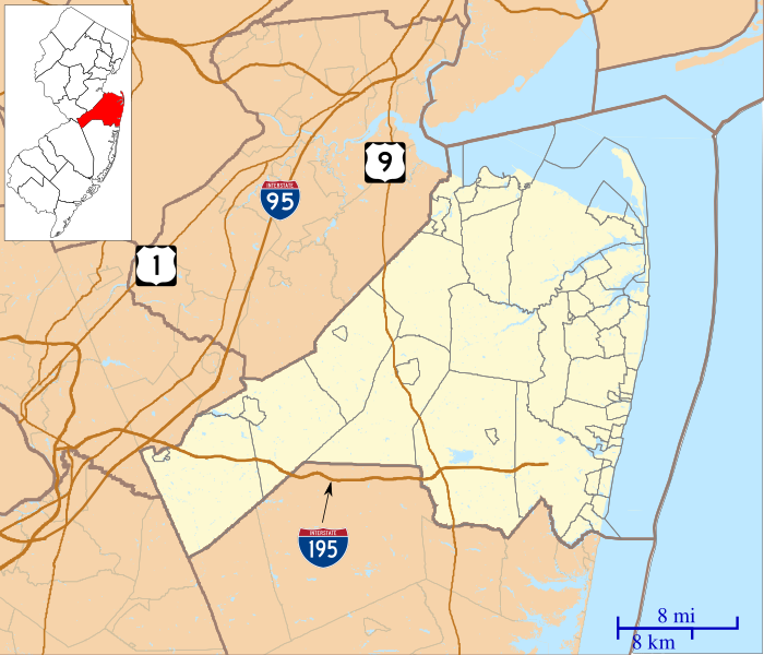
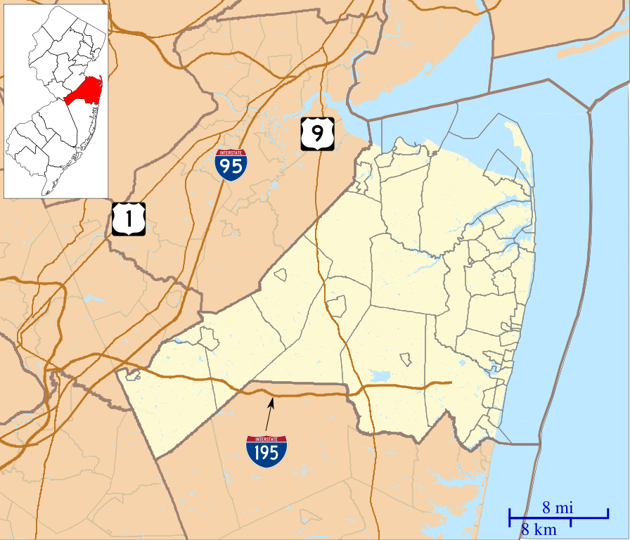
English: This is a map of Monmouth County, New Jersey, USA which includes incorporated settlements, township borders, and major highways. |
| ದಿನಾಂಕ | |
| ಆಕರ | My own work, using custom-written MapScript applications with United States Census Bureau data |
| ಕರ್ತೃ | Omnedon |
ಪರವಾನಗಿ
| I, the copyright holder of this work, release this work into the public domain. This applies worldwide. In some countries this may not be legally possible; if so: I grant anyone the right to use this work for any purpose, without any conditions, unless such conditions are required by law. |
ಕಡತದ ಇತಿಹಾಸ
ದಿನ/ಕಾಲ ಒತ್ತಿದರೆ ಆ ಸಮಯದಲ್ಲಿ ಈ ಕಡತದ ವಸ್ತುಸ್ಥಿತಿ ತೋರುತ್ತದೆ.
| ದಿನ/ಕಾಲ | ಕಿರುನೋಟ | ಆಯಾಮಗಳು | ಬಳಕೆದಾರ | ಟಿಪ್ಪಣಿ | |
|---|---|---|---|---|---|
| ಪ್ರಸಕ್ತ | ೦೭:೫೯, ೨೫ ಸೆಪ್ಟೆಂಬರ್ ೨೦೧೨ | | ೮೯೬ × ೭೬೮ (೧.೦೧ MB) | Omnedon | == {{int:filedesc}} == {{Information |Description={{en|This is a map of Monmouth County, New Jersey, USA which includes incorporated settlements, township borders, and major highways.}} |Source=My own work, using cust... |
ಕಡತ ಬಳಕೆ
ಈ ಕೆಳಗಿನ ಪುಟವು ಈ ಚಿತ್ರಕ್ಕೆ ಸಂಪರ್ಕ ಹೊಂದಿದೆ:
ಜಾಗತಿಕ ಕಡತ ಉಪಯೋಗ
ಈ ಕಡತವನ್ನು ಕೆಳಗಿನ ಬೇರೆ ವಿಕಿಗಳೂ ಉಪಯೋಗಿಸುತ್ತಿವೆ:
- ar.wikipedia.org ಮೇಲೆ ಬಳಕೆ
- azb.wikipedia.org ಮೇಲೆ ಬಳಕೆ
- کلیفوود، نیوجرسی
- ایملایزتاون، نیوجرسی
- کلارکسبرق، نیوجرسی
- البرون، نیوجرسی
- رابرتسویل، نیوجرسی
- آدلفیا، نیوجرسی
- سویتمان، نیوجرسی
- آلایر، نیوجرسی
- والنفورد، نیوجرسی
- دیل، نیوجرسی
- تننت، نیوجرسی
- واترویچ، نیوجرسی
- وایسید، نیوجرسی
- آسبوری پارک، نیوجرسی
- توون بروک، نیوجرسی
- وزت دیل، نیوجرسی
- وزت فارمز، نیوجرسی
- وزت قروو، نیوجرسی
- ویکاتونک، نیوجرسی
- برئیدولت، نیوجرسی
- واندربورق، نیوجرسی
- شارون، نیوجرسی
- ایسمیتبورق، نیوجرسی
- سوتارد، نیوجرسی
- ایسپرینق میل، نیوجرسی
- سکوانکوم، نیوجرسی
- ماتیوس، نیوجرسی
- ceb.wikipedia.org ಮೇಲೆ ಬಳಕೆ
- en.wikipedia.org ಮೇಲೆ ಬಳಕೆ
- Aberdeen Township, New Jersey
- Allenhurst, New Jersey
- Allentown, New Jersey
- Asbury Park, New Jersey
- Avon-by-the-Sea, New Jersey
- Belmar, New Jersey
- Brielle, New Jersey
- Cliffwood Beach, New Jersey
- Colts Neck Township, New Jersey
- East Freehold, New Jersey
- Englishtown, New Jersey
- Fair Haven, New Jersey
- Fairview, Monmouth County, New Jersey
- Farmingdale, New Jersey
- Freehold Borough, New Jersey
- Freehold Township, New Jersey
- Hazlet, New Jersey
- Highlands, New Jersey
- Howell Township, New Jersey
- Interlaken, New Jersey
- Keansburg, New Jersey
ಈ ಫೈಲ್ನ ಹೆಚ್ಚು ಜಾಗತಿಕ ಬಳಕೆಯನ್ನು ವೀಕ್ಷಿಸಿ.