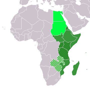
ಚಿತ್ರ:LocationEasternAfrica.png
LocationEasternAfrica.png (೩೫೯ × ೩೫೯ ಚಿತ್ರಬಿಂದು, ಫೈಲಿನ ಗಾತ್ರ: ೮ KB, MIME ಪ್ರಕಾರ: image/png)
ಕಡತದ ಇತಿಹಾಸ
ದಿನ/ಕಾಲ ಒತ್ತಿದರೆ ಆ ಸಮಯದಲ್ಲಿ ಈ ಕಡತದ ವಸ್ತುಸ್ಥಿತಿ ತೋರುತ್ತದೆ.
| ದಿನ/ಕಾಲ | ಕಿರುನೋಟ | ಆಯಾಮಗಳು | ಬಳಕೆದಾರ | ಟಿಪ್ಪಣಿ | |
|---|---|---|---|---|---|
| ಪ್ರಸಕ್ತ | ೧೮:೪೬, ೧೧ ನವೆಂಬರ್ ೨೦೨೨ |  | ೩೫೯ × ೩೫೯ (೮ KB) | ColorfulSmoke | . |
| ೧೭:೨೪, ೧೧ ನವೆಂಬರ್ ೨೦೨೨ |  | ೩೬೦ × ೩೫೯ (೮ KB) | ColorfulSmoke | ||
| ೨೨:೩೧, ೧೭ ಮಾರ್ಚ್ ೨೦೧೮ |  | ೩೬೦ × ೩೯೨ (೧೧ KB) | Maphobbyist | Upload | |
| ೦೬:೦೦, ೨೦ ಡಿಸೆಂಬರ್ ೨೦೧೨ |  | ೩೬೦ × ೩೯೨ (೮ KB) | Spacepotato | Recolor to reflect placement of South Sudan in Eastern Africa according to the UN classification scheme, http://unstats.un.org/unsd/methods/m49/m49regin.htm . | |
| ೨೨:೩೧, ೯ ಜುಲೈ ೨೦೧೧ |  | ೩೬೦ × ೩೯೨ (೧೪ KB) | Maphobbyist | South Sudan has become independent on July 9, 2011. Sudan and South Sudan are shown with the new international border between them. | |
| ೧೩:೪೫, ೧೧ ಡಿಸೆಂಬರ್ ೨೦೦೭ |  | ೩೬೦ × ೩೯೨ (೧೪ KB) | Hoshie | added Cabinda (Angola) and Montenegro. | |
| ೨೧:೨೬, ೨ ಏಪ್ರಿಲ್ ೨೦೦೬ |  | ೩೬೦ × ೩೯೨ (೯ KB) | E Pluribus Anthony~commonswiki | Reverted to earlier revision | |
| ೧೧:೧೭, ೧ ಏಪ್ರಿಲ್ ೨೦೦೬ |  | ೩೬೦ × ೩೯೨ (೧೪ KB) | Aris Katsaris | No need to include regional organizations -- it makes the map much harder to read for no relevant purpose. The map should be clear in its purpose. | |
| ೧೮:೦೭, ೫ ಫೆಬ್ರವರಿ ೨೦೦೬ |  | ೩೬೦ × ೩೯೨ (೯ KB) | E Pluribus Anthony~commonswiki | Map: Eastern Africa (location) |
ಕಡತ ಬಳಕೆ
ಈ ಕೆಳಗಿನ ಪುಟವು ಈ ಚಿತ್ರಕ್ಕೆ ಸಂಪರ್ಕ ಹೊಂದಿದೆ:
ಜಾಗತಿಕ ಕಡತ ಉಪಯೋಗ
ಈ ಕಡತವನ್ನು ಕೆಳಗಿನ ಬೇರೆ ವಿಕಿಗಳೂ ಉಪಯೋಗಿಸುತ್ತಿವೆ:
- ace.wikipedia.org ಮೇಲೆ ಬಳಕೆ
- af.wikipedia.org ಮೇಲೆ ಬಳಕೆ
- als.wikipedia.org ಮೇಲೆ ಬಳಕೆ
- am.wikipedia.org ಮೇಲೆ ಬಳಕೆ
- ar.wikipedia.org ಮೇಲೆ ಬಳಕೆ
- ليبيا
- جيبوتي
- موريتانيا
- تونس
- السودان
- الصحراء الغربية
- أنغولا
- أوغندا
- إسبانيا
- تشاد
- النيجر
- مالي
- السنغال
- غامبيا
- غينيا بيساو
- غينيا
- سيراليون
- ليبيريا
- غانا
- توغو
- بنين
- بوركينا فاسو
- الصومال
- كينيا
- تنزانيا
- الغابون
- زامبيا
- موزمبيق
- زيمبابوي
- البرتغال
- الكاميرون
- جمهورية الكونغو الديمقراطية
- بوتسوانا
- جنوب إفريقيا
- جمهورية إفريقيا الوسطى
- جمهورية الكونغو
- سيشل
- ناميبيا
- مدغشقر
- ليسوتو
- موريشيوس
- نهر النيل
ಈ ಫೈಲ್ನ ಹೆಚ್ಚು ಜಾಗತಿಕ ಬಳಕೆಯನ್ನು ವೀಕ್ಷಿಸಿ.


