
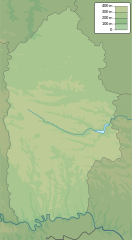
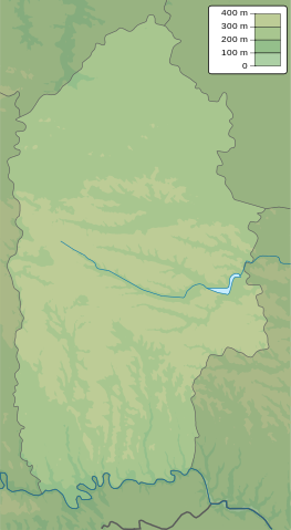
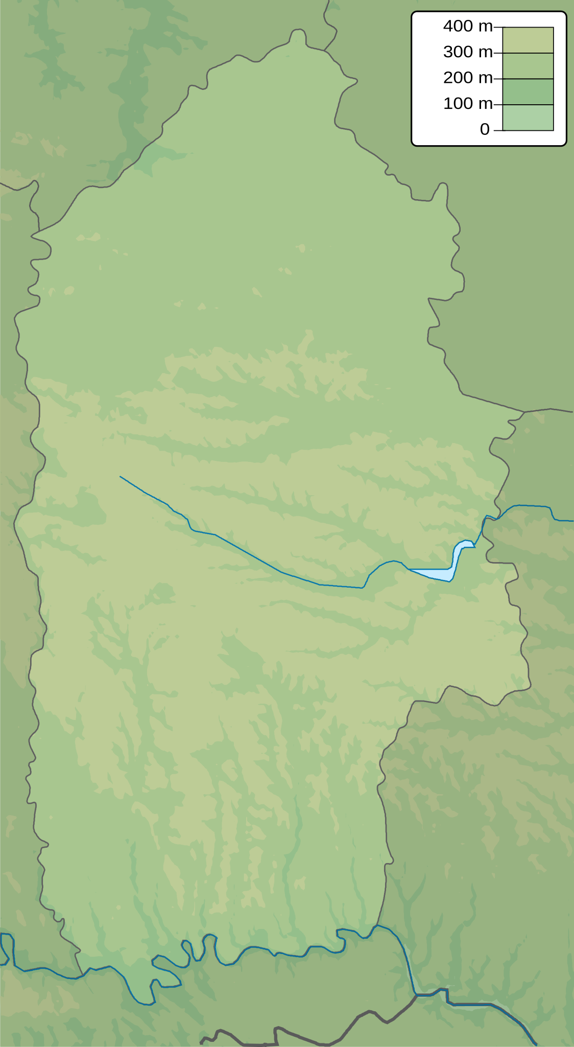
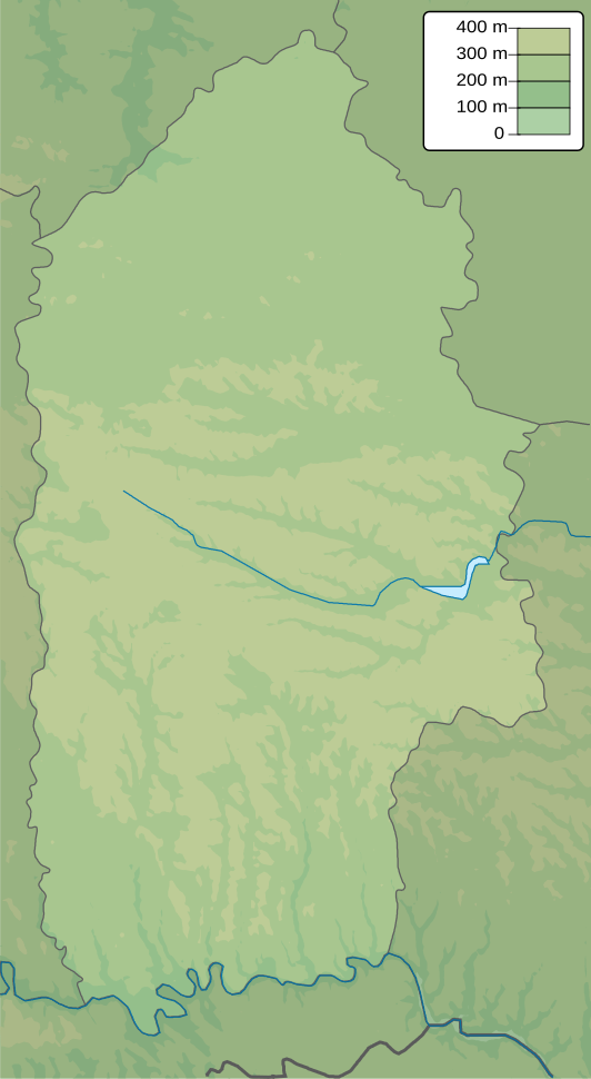
ಚಿತ್ರ:Khmelnytsky province physical map.svg

Size of this PNG preview of this SVG file: ೩೨೯ × ೫೯೯ ಪಿಕ್ಸೆಲ್ಗಳು. ಇತರ ರೆಸಲ್ಯೂಶನ್ಗಳು: ೧೩೨ × ೨೪೦ ಪಿಕ್ಸೆಲ್ಗಳು | ೨೬೩ × ೪೮೦ ಪಿಕ್ಸೆಲ್ಗಳು | ೪೨೧ × ೭೬೮ ಪಿಕ್ಸೆಲ್ಗಳು | ೫೬೨ × ೧,೦೨೪ ಪಿಕ್ಸೆಲ್ಗಳು | ೧,೧೨೪ × ೨,೦೪೮ ಪಿಕ್ಸೆಲ್ಗಳು | ೫೩೨ × ೯೬೯ ಪಿಕ್ಸೆಲ್ಗಳು.
ಮೂಲ ಕಡತ (SVG ಫೈಲು, ಸುಮಾರಾಗಿ ೫೩೨ × ೯೬೯ ಚಿತ್ರಬಿಂದುಗಳು, ಫೈಲಿನ ಗಾತ್ರ: ೭೧೦ KB)
ಈ ಫೈಲು ವಿಕಿಮೀಡಿಯ ಕಾಮನ್ಸ್ನಲ್ಲಿ ಇರುವುದು. ಅಲ್ಲಿನ ವಿವರಣೆ ಪುಟವನ್ನೇ ಕೆಳಗೆ ತೋರಿಸಲಾಗಿದೆ. ಕಾಮನ್ಸ್ ಕೃತಿಸ್ವಾಮ್ಯತೆಯಿಂದ ಮುಕ್ತ ಫೈಲುಗಳ ಒಂದು ಆಗರ. ಅಲ್ಲಿ ನೀವೂ ಸಹಕರಿಸಬಹುದು. |
ಸಾರಾಂಶ
| ವಿವರ |
English: Physical map of Khmelnytsky province, Ukraine
Русский: Физическая карта Хмельницкой области, Украина |
| ದಿನಾಂಕ | |
| ಆಕರ | ಸ್ವಂತ ಕೆಲಸ |
| ಕರ್ತೃ | Urutseg |
ಪರವಾನಗಿ
| I, the copyright holder of this work, release this work into the public domain. This applies worldwide. In some countries this may not be legally possible; if so: I grant anyone the right to use this work for any purpose, without any conditions, unless such conditions are required by law. |
ಕಡತದ ಇತಿಹಾಸ
ದಿನ/ಕಾಲ ಒತ್ತಿದರೆ ಆ ಸಮಯದಲ್ಲಿ ಈ ಕಡತದ ವಸ್ತುಸ್ಥಿತಿ ತೋರುತ್ತದೆ.
| ದಿನ/ಕಾಲ | ಕಿರುನೋಟ | ಆಯಾಮಗಳು | ಬಳಕೆದಾರ | ಟಿಪ್ಪಣಿ | |
|---|---|---|---|---|---|
| ಪ್ರಸಕ್ತ | ೨೩:೩೫, ೨೨ ಡಿಸೆಂಬರ್ ೨೦೧೦ | | ೫೩೨ × ೯೬೯ (೭೧೦ KB) | Urutseg |
ಕಡತ ಬಳಕೆ
ಈ ಕೆಳಗಿನ ಪುಟವು ಈ ಚಿತ್ರಕ್ಕೆ ಸಂಪರ್ಕ ಹೊಂದಿದೆ:
ಜಾಗತಿಕ ಕಡತ ಉಪಯೋಗ
ಈ ಕಡತವನ್ನು ಕೆಳಗಿನ ಬೇರೆ ವಿಕಿಗಳೂ ಉಪಯೋಗಿಸುತ್ತಿವೆ:
- ar.wikipedia.org ಮೇಲೆ ಬಳಕೆ
- be.wikipedia.org ಮೇಲೆ ಬಳಕೆ
- bg.wikipedia.org ಮೇಲೆ ಬಳಕೆ
- ceb.wikipedia.org ಮೇಲೆ ಬಳಕೆ
- ce.wikipedia.org ಮೇಲೆ ಬಳಕೆ
- da.wikipedia.org ಮೇಲೆ ಬಳಕೆ
- de.wikipedia.org ಮೇಲೆ ಬಳಕೆ
- en.wikipedia.org ಮೇಲೆ ಬಳಕೆ
- eo.wikipedia.org ಮೇಲೆ ಬಳಕೆ
- es.wikipedia.org ಮೇಲೆ ಬಳಕೆ
- fa.wikipedia.org ಮೇಲೆ ಬಳಕೆ
- fi.wikipedia.org ಮೇಲೆ ಬಳಕೆ
- fr.wikipedia.org ಮೇಲೆ ಬಳಕೆ
ಈ ಫೈಲ್ನ ಹೆಚ್ಚು ಜಾಗತಿಕ ಬಳಕೆಯನ್ನು ವೀಕ್ಷಿಸಿ.