
ಚಿತ್ರ:Katastrální mapa Prahy.PNG

ಈ ಮುನ್ನೋಟ ಗಾತ್ರ:೮೦೦ × ೫೮೫ ಪಿಕ್ಸೆಲ್ಗಳು. ಇತರ ರೆಸಲ್ಯೂಶನ್ಗಳು: ೩೨೦ × ೨೩೪ ಪಿಕ್ಸೆಲ್ಗಳು | ೬೪೦ × ೪೬೮ ಪಿಕ್ಸೆಲ್ಗಳು | ೧,೦೨೪ × ೭೪೯ ಪಿಕ್ಸೆಲ್ಗಳು | ೧,೩೭೩ × ೧,೦೦೪ ಪಿಕ್ಸೆಲ್ಗಳು.
ಮೂಲ ಕಡತ (೧,೩೭೩ × ೧,೦೦೪ ಚಿತ್ರಬಿಂದು, ಫೈಲಿನ ಗಾತ್ರ: ೮೭ KB, MIME ಪ್ರಕಾರ: image/png)
ಈ ಫೈಲು ವಿಕಿಮೀಡಿಯ ಕಾಮನ್ಸ್ನಲ್ಲಿ ಇರುವುದು. ಅಲ್ಲಿನ ವಿವರಣೆ ಪುಟವನ್ನೇ ಕೆಳಗೆ ತೋರಿಸಲಾಗಿದೆ. ಕಾಮನ್ಸ್ ಕೃತಿಸ್ವಾಮ್ಯತೆಯಿಂದ ಮುಕ್ತ ಫೈಲುಗಳ ಒಂದು ಆಗರ. ಅಲ್ಲಿ ನೀವೂ ಸಹಕರಿಸಬಹುದು. |

|
This locator map image could be re-created using vector graphics as an SVG file. This has several advantages; see Commons:Media for cleanup for more information. If an SVG form of this image is available, please upload it and afterwards replace this template with
{{vector version available|new image name}}.
It is recommended to name the SVG file “Katastrální mapa Prahy.svg”—then the template Vector version available (or Vva) does not need the new image name parameter. |
ಸಾರಾಂಶ
| ವಿವರ |
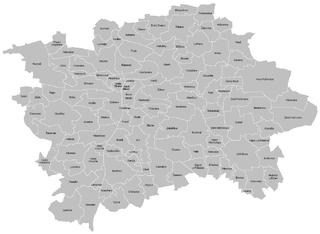
English: Cadastral map of Praha
Čeština: Katastrální mapa Prahy |
| ದಿನಾಂಕ | |
| ಆಕರ | ಸ್ವಂತ ಕೆಲಸ |
| ಕರ್ತೃ | Mapového náložník |
| ಇತರೆ ಆವೃತ್ತಿಗಳು | Derivative works of this file: Greater Prague.png |
ಪರವಾನಗಿ
| I, the copyright holder of this work, release this work into the public domain. This applies worldwide. In some countries this may not be legally possible; if so: I grant anyone the right to use this work for any purpose, without any conditions, unless such conditions are required by law. |
ಕಡತದ ಇತಿಹಾಸ
ದಿನ/ಕಾಲ ಒತ್ತಿದರೆ ಆ ಸಮಯದಲ್ಲಿ ಈ ಕಡತದ ವಸ್ತುಸ್ಥಿತಿ ತೋರುತ್ತದೆ.
| ದಿನ/ಕಾಲ | ಕಿರುನೋಟ | ಆಯಾಮಗಳು | ಬಳಕೆದಾರ | ಟಿಪ್ಪಣಿ | |
|---|---|---|---|---|---|
| ಪ್ರಸಕ್ತ | ೨೨:೩೪, ೨೪ ಮಾರ್ಚ್ ೨೦೧೧ | | ೧,೩೭೩ × ೧,೦೦೪ (೮೭ KB) | Mapového náložník | {{Information |Description ={{en|1=Cadastral map of Praha}} {{cs|1=Katastrální mapa Prahy}} |Source ={{own}} |Author =Mapového náložník |Date =23.3.2011 |Permission = |other_versions = |
ಕಡತ ಬಳಕೆ
ಈ ಕೆಳಗಿನ ಪುಟವು ಈ ಚಿತ್ರಕ್ಕೆ ಸಂಪರ್ಕ ಹೊಂದಿದೆ:
ಜಾಗತಿಕ ಕಡತ ಉಪಯೋಗ
ಈ ಕಡತವನ್ನು ಕೆಳಗಿನ ಬೇರೆ ವಿಕಿಗಳೂ ಉಪಯೋಗಿಸುತ್ತಿವೆ:
- ar.wikipedia.org ಮೇಲೆ ಬಳಕೆ
- be-tarask.wikipedia.org ಮೇಲೆ ಬಳಕೆ
- ceb.wikipedia.org ಮೇಲೆ ಬಳಕೆ
- cs.wikipedia.org ಮೇಲೆ ಬಳಕೆ
- en.wikipedia.org ಮೇಲೆ ಬಳಕೆ
- Můstek
- Muzeum (Prague Metro)
- Náměstí Míru (Prague Metro)
- Zličín (Prague Metro)
- Nové Butovice (Prague Metro)
- Náměstí Republiky (Prague Metro)
- Florenc (Prague Metro)
- Českomoravská
- Ládví (Prague Metro)
- Kobylisy (Prague Metro)
- Nádraží Holešovice (Prague Metro)
- Vltavská (Prague Metro)
- Hlavní nádraží (Prague Metro)
- I. P. Pavlova (Prague Metro)
- Vyšehrad (Prague Metro)
- Pražského povstání (Prague Metro)
- Pankrác (Prague Metro)
- Budějovická (Prague Metro)
- Kačerov (Prague Metro)
- Roztyly (Prague Metro)
- Chodov (Prague Metro)
- Opatov (Prague Metro)
- Háje (Prague Metro)
- Football in the Czech Republic
- Střížkov (Prague Metro)
- Prosek (Prague Metro)
- Letňany (Prague Metro)
- Morzin Palace
- Module:Location map/data/Czech Republic Greater Prague/doc
- Straka Academy
- Prague–Kbely Airport
- Module:Location map/data/Czech Republic Greater Prague
- fa.wikipedia.org ಮೇಲೆ ಬಳಕೆ
- ja.wikipedia.org ಮೇಲೆ ಬಳಕೆ
- mk.wikipedia.org ಮೇಲೆ ಬಳಕೆ
- si.wikipedia.org ಮೇಲೆ ಬಳಕೆ
- tr.wikipedia.org ಮೇಲೆ ಬಳಕೆ
ಈ ಫೈಲ್ನ ಹೆಚ್ಚು ಜಾಗತಿಕ ಬಳಕೆಯನ್ನು ವೀಕ್ಷಿಸಿ.