
ಚಿತ್ರ:Java Locator Topography.png

ಈ ಮುನ್ನೋಟ ಗಾತ್ರ:೮೦೦ × ೫೧೫ ಪಿಕ್ಸೆಲ್ಗಳು. ಇತರ ರೆಸಲ್ಯೂಶನ್ಗಳು: ೩೨೦ × ೨೦೬ ಪಿಕ್ಸೆಲ್ಗಳು | ೬೪೦ × ೪೧೨ ಪಿಕ್ಸೆಲ್ಗಳು | ೧,೦೨೪ × ೬೬೦ ಪಿಕ್ಸೆಲ್ಗಳು | ೧,೨೮೦ × ೮೨೫ ಪಿಕ್ಸೆಲ್ಗಳು | ೨,೫೨೫ × ೧,೬೨೭ ಪಿಕ್ಸೆಲ್ಗಳು.
ಮೂಲ ಕಡತ (೨,೫೨೫ × ೧,೬೨೭ ಚಿತ್ರಬಿಂದು, ಫೈಲಿನ ಗಾತ್ರ: ೧.೩೬ MB, MIME ಪ್ರಕಾರ: image/png)
ಈ ಫೈಲು ವಿಕಿಮೀಡಿಯ ಕಾಮನ್ಸ್ನಲ್ಲಿ ಇರುವುದು. ಅಲ್ಲಿನ ವಿವರಣೆ ಪುಟವನ್ನೇ ಕೆಳಗೆ ತೋರಿಸಲಾಗಿದೆ. ಕಾಮನ್ಸ್ ಕೃತಿಸ್ವಾಮ್ಯತೆಯಿಂದ ಮುಕ್ತ ಫೈಲುಗಳ ಒಂದು ಆಗರ. ಅಲ್ಲಿ ನೀವೂ ಸಹಕರಿಸಬಹುದು. |
ಸಾರಾಂಶ
| ವಿವರ |
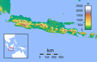
Topographic location map of Java (Indonesia). Created with GMT from SRTM data Left: 104.5, Right: 117.0, Bottom: -12.0666667 Top: -4.0. For non-locator version, see Image:Java Topography.png |
| ದಿನಾಂಕ | |
| ಆಕರ | ಸ್ವಂತ ಕೆಲಸ |
| ಕರ್ತೃ | Sadalmelik |
ಪರವಾನಗಿ
| I, the copyright holder of this work, release this work into the public domain. This applies worldwide. In some countries this may not be legally possible; if so: I grant anyone the right to use this work for any purpose, without any conditions, unless such conditions are required by law. |
ಕಡತದ ಇತಿಹಾಸ
ದಿನ/ಕಾಲ ಒತ್ತಿದರೆ ಆ ಸಮಯದಲ್ಲಿ ಈ ಕಡತದ ವಸ್ತುಸ್ಥಿತಿ ತೋರುತ್ತದೆ.
| ದಿನ/ಕಾಲ | ಕಿರುನೋಟ | ಆಯಾಮಗಳು | ಬಳಕೆದಾರ | ಟಿಪ್ಪಣಿ | |
|---|---|---|---|---|---|
| ಪ್ರಸಕ್ತ | ೦೩:೫೪, ೯ ಜೂನ್ ೨೦೧೦ | | ೨,೫೨೫ × ೧,೬೨೭ (೧.೩೬ MB) | Ras67 | cropped |
| ೨೩:೪೩, ೩೦ ಆಗಸ್ಟ್ ೨೦೦೭ |  | ೨,೫೪೬ × ೧,೬೪೪ (೧.೩೭ MB) | Sadalmelik | {{Information |Description=Topographic location map of Java (Indonesia). Created with GMT from SRTM data Left: 104.5, Right: 117.0, Bottom: -12.0666667 Top: -4.0 |Source=self-made |Date=30 August, 2007 |Author= Sadalmelik }} [[Categor |
ಕಡತ ಬಳಕೆ
ಈ ಕೆಳಗಿನ ಪುಟವು ಈ ಚಿತ್ರಕ್ಕೆ ಸಂಪರ್ಕ ಹೊಂದಿದೆ:
ಜಾಗತಿಕ ಕಡತ ಉಪಯೋಗ
ಈ ಕಡತವನ್ನು ಕೆಳಗಿನ ಬೇರೆ ವಿಕಿಗಳೂ ಉಪಯೋಗಿಸುತ್ತಿವೆ:
- an.wikipedia.org ಮೇಲೆ ಬಳಕೆ
- ar.wikipedia.org ಮೇಲೆ ಬಳಕೆ
- ceb.wikipedia.org ಮೇಲೆ ಬಳಕೆ
- cs.wikipedia.org ಮೇಲೆ ಬಳಕೆ
- en.wikipedia.org ಮೇಲೆ ಬಳಕೆ
- es.wikipedia.org ಮೇಲೆ ಬಳಕೆ
- fr.wikipedia.org ಮೇಲೆ ಬಳಕೆ
- Temple de Borobudur
- Merapi
- Bromo
- Caldeira Tengger
- Îles Karimunjawa
- Wilis
- Kamojang
- Mont Gede
- Mont Penanggungan
- Parc national d'Ujung Kulon
- Péninsule de Blambangan
- Semeru
- Merapi (Ijen)
- Kawah Ijen
- Guntur (Indonésie)
- Parc national de Meru Betiri
- Arjuno-Welirang
- Lawu
- Homme de Java
- Kelud
- Raung
- Plateau de Dieng
- Parc national de Bromo-Tengger-Semeru
- Butak
- Kawi (volcan)
- Argapura
- Parc national d'Alas Purwo
- Baluran
- Parc national de Baluran
- Segara Anakan
- Slamet
- Massacre de Rawagede
- Ciremai
- Parc national Halimun Salak
ಈ ಫೈಲ್ನ ಹೆಚ್ಚು ಜಾಗತಿಕ ಬಳಕೆಯನ್ನು ವೀಕ್ಷಿಸಿ.