
ಚಿತ್ರ:Italy Sardinia location map IT.svg

Size of this PNG preview of this SVG file: ೩೩೪ × ೫೯೯ ಪಿಕ್ಸೆಲ್ಗಳು. ಇತರ ರೆಸಲ್ಯೂಶನ್ಗಳು: ೧೩೪ × ೨೪೦ ಪಿಕ್ಸೆಲ್ಗಳು | ೨೬೭ × ೪೮೦ ಪಿಕ್ಸೆಲ್ಗಳು | ೪೨೮ × ೭೬೮ ಪಿಕ್ಸೆಲ್ಗಳು | ೫೭೧ × ೧,೦೨೪ ಪಿಕ್ಸೆಲ್ಗಳು | ೧,೧೪೨ × ೨,೦೪೮ ಪಿಕ್ಸೆಲ್ಗಳು | ೬೦೧ × ೧,೦೭೮ ಪಿಕ್ಸೆಲ್ಗಳು.
ಮೂಲ ಕಡತ (SVG ಫೈಲು, ಸುಮಾರಾಗಿ ೬೦೧ × ೧,೦೭೮ ಚಿತ್ರಬಿಂದುಗಳು, ಫೈಲಿನ ಗಾತ್ರ: ೧.೨೨ MB)
ಈ ಫೈಲು ವಿಕಿಮೀಡಿಯ ಕಾಮನ್ಸ್ನಲ್ಲಿ ಇರುವುದು. ಅಲ್ಲಿನ ವಿವರಣೆ ಪುಟವನ್ನೇ ಕೆಳಗೆ ತೋರಿಸಲಾಗಿದೆ. ಕಾಮನ್ಸ್ ಕೃತಿಸ್ವಾಮ್ಯತೆಯಿಂದ ಮುಕ್ತ ಫೈಲುಗಳ ಒಂದು ಆಗರ. ಅಲ್ಲಿ ನೀವೂ ಸಹಕರಿಸಬಹುದು. |
ಸಾರಾಂಶ
| ವಿವರ |
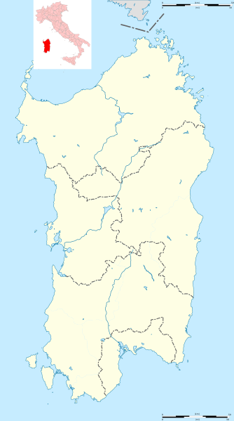
English: Blank administrative map of Sardinia, Italy, for geo-location purpose, with province boundaries. Each province could be coloured independently. Français : Carte administrative vierge de la Sardaigne, Italie, destinée à la géolocalisation, avec les limites des provinces. Chaque province peut être colorée indépendamment. Equirectangular projection, WGS84 datum
Geographic limits of the map:
|
| ದಿನಾಂಕ | (UTC) |
| ಆಕರ |
ಸ್ವಂತ ಕೆಲಸ
|
| ಕರ್ತೃ | Hanhil (talk) 13:54, 26 May 2011 (UTC) based on File:Italy Sardinia location map.svg by Sémhur (talk) |
| ಇತರೆ ಆವೃತ್ತಿಗಳು |
Derivative works of this file: Isole della Sardegna.svg
|


| Camera location | | View this and other nearby images on: OpenStreetMap |
|---|
ಪರವಾನಗಿ
I, the copyright holder of this work, hereby publish it under the following license:
ಈ ಕಡತ ಕ್ರಿಯೇಟಿವ್ ಕಾಮನ್ಸ್ Attribution
-Share Alike 3.0 Unported ಪರವಾನಗಿ ಹೊಂದಿದೆ.
- ನೀವು ಮುಕ್ತ:
- ಹಂಚಿಕೆಗೆ – ಕೆಲಸವನ್ನು ನಕಲು ಮಾಡಲು, ವಿತರಣೆ ಮತ್ತು ಸಾಗಿಸಲು
- ರೀಮಿಕ್ಸ್ ಮಾಡಲು – ಕೆಲಸವನ್ನು ಬಳಸಿಕೊಳ್ಳಲು
- ಈ ಕೆಳಗಿನ ಷರತ್ತುಗಳಲ್ಲಿ:
- ವೈಶಿಷ್ಟ್ಯ – ನೀವು ಸೂಕ್ತವಾದ ಕ್ರೆಡಿಟ್ ನೀಡಬೇಕು, ಪರವಾನಗಿಗೆ ಲಿಂಕ್ ಅನ್ನು ಒದಗಿಸಬೇಕು ಮತ್ತು ಯಾವುದೇ ಬದಲಾವಣೆಗಳನ್ನು ಮಾಡಿದ್ದರೆ ಸೂಚಿಸಬೇಕು. ನೀವು ಯಾವುದೇ ಸಮಂಜಸವಾದ ರೀತಿಯಲ್ಲಿ ಮಾಡಬಹುದು, ಆದರೆ ಪರವಾನಗಿದಾರರು ನಿಮ್ಮನ್ನು ಅಥವಾ ನಿಮ್ಮ ಯಾವುದೇ ಬಳಕೆಯನ್ನು ಅನುಮೋದಿಸಿದಂತೆ ರೀತಿಯಲ್ಲಿ ಉಪಯೋಗಿಸಬಾರದು.
- ಇರುವುದರಂತೆಯೇ ಹಂಚು – ನೀವು ರೀಮಿಕ್ಸ್ ಮಾಡಿದರೆ, ರೂಪಾಂತರಗೊಳಿಸಿದರೆ ಅಥವಾ ವಸ್ತುವಿನ ಮೇಲೆ ನಿರ್ಮಿಸಿದರೆ, ನಿಮ್ಮ ಕೊಡುಗೆಗಳನ್ನು ನೀವು ಮೂಲದಂತೆ ಅದೇ ಅಥವಾ ಹೊಂದಾಣಿಕೆಯ ಪರವಾನಗಿ ಅಡಿಯಲ್ಲಿ ವಿತರಿಸಬೇಕು.
ಕಡತದ ಇತಿಹಾಸ
ದಿನ/ಕಾಲ ಒತ್ತಿದರೆ ಆ ಸಮಯದಲ್ಲಿ ಈ ಕಡತದ ವಸ್ತುಸ್ಥಿತಿ ತೋರುತ್ತದೆ.
| ದಿನ/ಕಾಲ | ಕಿರುನೋಟ | ಆಯಾಮಗಳು | ಬಳಕೆದಾರ | ಟಿಪ್ಪಣಿ | |
|---|---|---|---|---|---|
| ಪ್ರಸಕ್ತ | ೨೧:೨೧, ೪ ಮಾರ್ಚ್ ೨೦೧೮ | | ೬೦೧ × ೧,೦೭೮ (೧.೨೨ MB) | Ruthven | Province boundaries of 2016 |
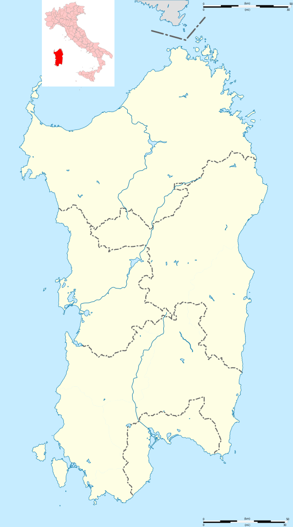
| ೧೯:೨೪, ೨೬ ಮೇ ೨೦೧೧ |  | ೬೦೧ × ೧,೦೭೮ (೧.೨೫ MB) | Hanhil | == {{int:filedesc}} == {{Information |Description={{Multilingual description |en=Blank administrative map of Sardinia, Italy, for geo-location purpose, with province boundaries. Each province could be coloured independently. |fr=Carte adm |
ಕಡತ ಬಳಕೆ
ಈ ಕೆಳಗಿನ ಪುಟವು ಈ ಚಿತ್ರಕ್ಕೆ ಸಂಪರ್ಕ ಹೊಂದಿದೆ:
ಜಾಗತಿಕ ಕಡತ ಉಪಯೋಗ
ಈ ಕಡತವನ್ನು ಕೆಳಗಿನ ಬೇರೆ ವಿಕಿಗಳೂ ಉಪಯೋಗಿಸುತ್ತಿವೆ:
- azb.wikipedia.org ಮೇಲೆ ಬಳಕೆ
- ویلاپروچیو
- ویلا ورده
- ویلا سن پیترو
- ویلا سانتآنتونیو
- ویدالبا
- تراماتسا
- ترالبا
- تراتالیاس
- تتی (ساردینیا)
- تالانا
- تاداسونی
- کیارامونتی
- کووارتو سنت النا
- پیمنتل، ساردینیا
- پیسچیناس
- والهدوریا
- کولیناس
- کولیری
- والرموزا
- کوسوینه
- نئونلی
- نیورو
- کارلوفورته
- پومپو
- کارددو
- کارجقه
- کورکوریس
- نوله (کومونه)
- نولوی
- پولا، ساردینیا
- نوکسیس
- نوقدو سانتا ویتوریا
- نوقدو سان نیکولو
- کاربونیا
- نوری (ساردینیا)
- نورچی
- پوزادا، ساردینیا
- نوربلو
- نورامینیس
- نورالاو
- نوراقوقومه
- نوراقوس
- نوراچی
- پورتوسکوزو
- کودرونجیانوس
- پورتو تورس
- کاپوترا
- نارکائو
- ناربولیا
- کوارتوچیو
ಈ ಫೈಲ್ನ ಹೆಚ್ಚು ಜಾಗತಿಕ ಬಳಕೆಯನ್ನು ವೀಕ್ಷಿಸಿ.