
ಚಿತ್ರ:Isles of Scilly UK location map.svg

Size of this PNG preview of this SVG file: ೬೭೭ × ೬೦೦ ಪಿಕ್ಸೆಲ್ಗಳು. ಇತರ ರೆಸಲ್ಯೂಶನ್ಗಳು: ೨೭೧ × ೨೪೦ ಪಿಕ್ಸೆಲ್ಗಳು | ೫೪೨ × ೪೮೦ ಪಿಕ್ಸೆಲ್ಗಳು | ೮೬೭ × ೭೬೮ ಪಿಕ್ಸೆಲ್ಗಳು | ೧,೧೫೬ × ೧,೦೨೪ ಪಿಕ್ಸೆಲ್ಗಳು | ೨,೩೧೨ × ೨,೦೪೮ ಪಿಕ್ಸೆಲ್ಗಳು | ೧,೩೪೦ × ೧,೧೮೭ ಪಿಕ್ಸೆಲ್ಗಳು.
ಮೂಲ ಕಡತ (SVG ಫೈಲು, ಸುಮಾರಾಗಿ ೧,೩೪೦ × ೧,೧೮೭ ಚಿತ್ರಬಿಂದುಗಳು, ಫೈಲಿನ ಗಾತ್ರ: ೫೫೮ KB)
ಈ ಫೈಲು ವಿಕಿಮೀಡಿಯ ಕಾಮನ್ಸ್ನಲ್ಲಿ ಇರುವುದು. ಅಲ್ಲಿನ ವಿವರಣೆ ಪುಟವನ್ನೇ ಕೆಳಗೆ ತೋರಿಸಲಾಗಿದೆ. ಕಾಮನ್ಸ್ ಕೃತಿಸ್ವಾಮ್ಯತೆಯಿಂದ ಮುಕ್ತ ಫೈಲುಗಳ ಒಂದು ಆಗರ. ಅಲ್ಲಿ ನೀವೂ ಸಹಕರಿಸಬಹುದು. |
| ವಿವರ |
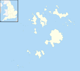
Blank map of the Isles of Scilly, UK with districts shown. Equirectangular map projection on WGS 84 datum, with N/S stretched 150% Geographic limits:
|
| ದಿನಾಂಕ | |
| ಆಕರ | Ordnance Survey OpenData. Most data from Boundary-Line product. Lake data from Meridian 2 product. Inset derived from England location map.svg by Spischot. |
| ಕರ್ತೃ | Nilfanion, created using Ordnance Survey data |
| ಅನುಮತಿ (ಈ ಕಡತವನ್ನು ಮರುಬಳಕೆ ಮಾಡಲಾಗುತ್ತಿದೆ) |
ಈ ಕಡತ ಕ್ರಿಯೇಟಿವ್ ಕಾಮನ್ಸ್ Attribution
-Share Alike 3.0 Unported ಪರವಾನಗಿ ಹೊಂದಿದೆ. ವೈಶಿಷ್ಟ್ಯ: Contains Ordnance Survey data © Crown copyright and database right
|
ಕಡತದ ಇತಿಹಾಸ
ದಿನ/ಕಾಲ ಒತ್ತಿದರೆ ಆ ಸಮಯದಲ್ಲಿ ಈ ಕಡತದ ವಸ್ತುಸ್ಥಿತಿ ತೋರುತ್ತದೆ.
| ದಿನ/ಕಾಲ | ಕಿರುನೋಟ | ಆಯಾಮಗಳು | ಬಳಕೆದಾರ | ಟಿಪ್ಪಣಿ | |
|---|---|---|---|---|---|
| ಪ್ರಸಕ್ತ | ೦೨:೦೯, ೨೭ ಸೆಪ್ಟೆಂಬರ್ ೨೦೧೦ | | ೧,೩೪೦ × ೧,೧೮೭ (೫೫೮ KB) | Nilfanion | {{Information |Description=Blank map of the Isles of Scilly, UK with districts shown. Equirectangular map projection on WGS 84 datum, with N/S stretched 150% Geographic limits: *West: 6.45W *East: 6.23W *North: 49.99N *South: 49.86 |
ಕಡತ ಬಳಕೆ
ಈ ಕೆಳಗಿನ ಪುಟವು ಈ ಚಿತ್ರಕ್ಕೆ ಸಂಪರ್ಕ ಹೊಂದಿದೆ:
ಜಾಗತಿಕ ಕಡತ ಉಪಯೋಗ
ಈ ಕಡತವನ್ನು ಕೆಳಗಿನ ಬೇರೆ ವಿಕಿಗಳೂ ಉಪಯೋಗಿಸುತ್ತಿವೆ:
- af.wikipedia.org ಮೇಲೆ ಬಳಕೆ
- ar.wikipedia.org ಮೇಲೆ ಬಳಕೆ
- arz.wikipedia.org ಮೇಲೆ ಬಳಕೆ
- ast.wikipedia.org ಮೇಲೆ ಬಳಕೆ
- ca.wikipedia.org ಮೇಲೆ ಬಳಕೆ
- ceb.wikipedia.org ಮೇಲೆ ಬಳಕೆ
- de.wikipedia.org ಮೇಲೆ ಬಳಕೆ
- Bishop Rock
- Samson (Insel)
- Annet (Scilly-Inseln)
- St Mary’s (Scilly-Inseln)
- St Mary’s Airport
- Tresco
- Hugh Town
- St. Martin’s
- Great Ganilly
- Teän
- St. Helen’s
- Zantman’s Rock
- Crim Rocks
- Round Island (Scilly-Inseln)
- Rosevear
- Bryher
- Gweal
- Gugh
- Vorlage:Positionskarte England Scilly-Inseln
- St. Agnes (Scilly-Inseln)
- White Island (Scilly-Inseln)
- Norrard Rocks
- Western Rocks (Scilly-Inseln)
- Eastern Isles
- Tresco Heliport
- el.wikipedia.org ಮೇಲೆ ಬಳಕೆ
- en.wikipedia.org ಮೇಲೆ ಬಳಕೆ
- Samson, Isles of Scilly
- Tresco, Isles of Scilly
- St Mary's, Isles of Scilly
- Hugh Town
- HMS Colossus (1787)
- Bant's Carn
- Porth Hellick Down
- Pednathise Head
- St Agnes, Isles of Scilly
- Bryher
- St Martin's, Isles of Scilly
- Zantman's Rock
- MV Cita
- Minnehaha (cargo ship)
- SS Thames
- Annet, Isles of Scilly
- Crim Rocks
ಈ ಫೈಲ್ನ ಹೆಚ್ಚು ಜಾಗತಿಕ ಬಳಕೆಯನ್ನು ವೀಕ್ಷಿಸಿ.