
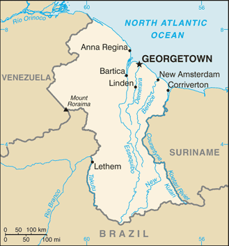
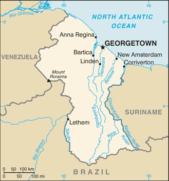
ಚಿತ್ರ:Guyana-CIA WFB Map.png
ಇದಕ್ಕಿಂತ ಹೆಚ್ಚಿನ ವಿವರವಾದ ನೋಟ ಇಲ್ಲ.
Guyana-CIA_WFB_Map.png (೩೨೯ × ೩೫೩ ಚಿತ್ರಬಿಂದು, ಫೈಲಿನ ಗಾತ್ರ: ೧೭ KB, MIME ಪ್ರಕಾರ: image/png)
ಈ ಫೈಲು ವಿಕಿಮೀಡಿಯ ಕಾಮನ್ಸ್ನಲ್ಲಿ ಇರುವುದು. ಅಲ್ಲಿನ ವಿವರಣೆ ಪುಟವನ್ನೇ ಕೆಳಗೆ ತೋರಿಸಲಾಗಿದೆ. ಕಾಮನ್ಸ್ ಕೃತಿಸ್ವಾಮ್ಯತೆಯಿಂದ ಮುಕ್ತ ಫೈಲುಗಳ ಒಂದು ಆಗರ. ಅಲ್ಲಿ ನೀವೂ ಸಹಕರಿಸಬಹುದು. |
ಸಾರಾಂಶ
| ವಿವರ |
English: Map of Guyana.
Français : Carte du Guyana.
Italiano: Mappa della Guyana. |
|||
| ದಿನಾಂಕ | ||||
| ಆಕರ | https://www.cia.gov/the-world-factbook/static/maps/GY-map.jpg | |||
| ಕರ್ತೃ | Directorate of Intelligence, CIA | |||
| ಅನುಮತಿ (ಈ ಕಡತವನ್ನು ಮರುಬಳಕೆ ಮಾಡಲಾಗುತ್ತಿದೆ) |
|
|||
| ಇತರೆ ಆವೃತ್ತಿಗಳು |
|


ಕಡತದ ಇತಿಹಾಸ
ದಿನ/ಕಾಲ ಒತ್ತಿದರೆ ಆ ಸಮಯದಲ್ಲಿ ಈ ಕಡತದ ವಸ್ತುಸ್ಥಿತಿ ತೋರುತ್ತದೆ.
| ದಿನ/ಕಾಲ | ಕಿರುನೋಟ | ಆಯಾಮಗಳು | ಬಳಕೆದಾರ | ಟಿಪ್ಪಣಿ | |
|---|---|---|---|---|---|
| ಪ್ರಸಕ್ತ | ೧೩:೩೨, ೨೧ ಜುಲೈ ೨೦೦೭ | | ೩೨೯ × ೩೫೩ (೧೭ KB) | Hoshie | Updated map of Guyana from the CIA World Factbook, 14 June 07 rev. Src: https://www.cia.gov/library/publications/the-world-factbook/maps/gy-map.gif |
| ೧೪:೪೪, ೨೭ ಮಾರ್ಚ್ ೨೦೦೫ |  | ೩೨೯ × ೭೦೬ (೧೦ KB) | Wolfman~commonswiki | {{CIA-map}} |
ಕಡತ ಬಳಕೆ
ಈ ಕೆಳಗಿನ 2 ಪುಟಗಳು ಈ ಚಿತ್ರಕ್ಕೆ ಸಂಪರ್ಕ ಹೊಂದಿವೆ:
ಜಾಗತಿಕ ಕಡತ ಉಪಯೋಗ
ಈ ಕಡತವನ್ನು ಕೆಳಗಿನ ಬೇರೆ ವಿಕಿಗಳೂ ಉಪಯೋಗಿಸುತ್ತಿವೆ:
- af.wikipedia.org ಮೇಲೆ ಬಳಕೆ
- be-tarask.wikipedia.org ಮೇಲೆ ಬಳಕೆ
- de.wikipedia.org ಮೇಲೆ ಬಳಕೆ
- de.wiktionary.org ಮೇಲೆ ಬಳಕೆ
- dsb.wikipedia.org ಮೇಲೆ ಬಳಕೆ
- en.wikipedia.org ಮೇಲೆ ಬಳಕೆ
- en.wikinews.org ಮೇಲೆ ಬಳಕೆ
- en.wikisource.org ಮೇಲೆ ಬಳಕೆ
- eo.wikipedia.org ಮೇಲೆ ಬಳಕೆ
- es.wikipedia.org ಮೇಲೆ ಬಳಕೆ
- fa.wikipedia.org ಮೇಲೆ ಬಳಕೆ
- fi.wikipedia.org ಮೇಲೆ ಬಳಕೆ
- frr.wikipedia.org ಮೇಲೆ ಬಳಕೆ
- fy.wikipedia.org ಮೇಲೆ ಬಳಕೆ
- gom.wikipedia.org ಮೇಲೆ ಬಳಕೆ
- hi.wikipedia.org ಮೇಲೆ ಬಳಕೆ
- hr.wikipedia.org ಮೇಲೆ ಬಳಕೆ
- hu.wikipedia.org ಮೇಲೆ ಬಳಕೆ
- it.wikipedia.org ಮೇಲೆ ಬಳಕೆ
- ja.wikipedia.org ಮೇಲೆ ಬಳಕೆ
- la.wikipedia.org ಮೇಲೆ ಬಳಕೆ
- lb.wikipedia.org ಮೇಲೆ ಬಳಕೆ
- lfn.wikipedia.org ಮೇಲೆ ಬಳಕೆ
- lld.wikipedia.org ಮೇಲೆ ಬಳಕೆ
- lt.wiktionary.org ಮೇಲೆ ಬಳಕೆ
- ml.wikipedia.org ಮೇಲೆ ಬಳಕೆ
- mr.wikipedia.org ಮೇಲೆ ಬಳಕೆ
- nds.wikipedia.org ಮೇಲೆ ಬಳಕೆ
ಈ ಫೈಲ್ನ ಹೆಚ್ಚು ಜಾಗತಿಕ ಬಳಕೆಯನ್ನು ವೀಕ್ಷಿಸಿ.