
ಚಿತ್ರ:East Timor relief location map.jpg
ಈ ಮುನ್ನೋಟ ಗಾತ್ರ:೮೦೦ × ೪೮೯ ಪಿಕ್ಸೆಲ್ಗಳು. ಇತರ ರೆಸಲ್ಯೂಶನ್ಗಳು: ೩೨೦ × ೧೯೬ ಪಿಕ್ಸೆಲ್ಗಳು | ೬೪೦ × ೩೯೧ ಪಿಕ್ಸೆಲ್ಗಳು | ೧,೦೨೪ × ೬೨೬ ಪಿಕ್ಸೆಲ್ಗಳು | ೧,೨೮೦ × ೭೮೩ ಪಿಕ್ಸೆಲ್ಗಳು | ೨,೦೦೦ × ೧,೨೨೩ ಪಿಕ್ಸೆಲ್ಗಳು.
ಮೂಲ ಕಡತ (೨,೦೦೦ × ೧,೨೨೩ ಚಿತ್ರಬಿಂದು, ಫೈಲಿನ ಗಾತ್ರ: ೬೫೭ KB, MIME ಪ್ರಕಾರ: image/jpeg)
ಈ ಫೈಲು ವಿಕಿಮೀಡಿಯ ಕಾಮನ್ಸ್ನಲ್ಲಿ ಇರುವುದು. ಅಲ್ಲಿನ ವಿವರಣೆ ಪುಟವನ್ನೇ ಕೆಳಗೆ ತೋರಿಸಲಾಗಿದೆ. ಕಾಮನ್ಸ್ ಕೃತಿಸ್ವಾಮ್ಯತೆಯಿಂದ ಮುಕ್ತ ಫೈಲುಗಳ ಒಂದು ಆಗರ. ಅಲ್ಲಿ ನೀವೂ ಸಹಕರಿಸಬಹುದು. |
| ವಿವರ |
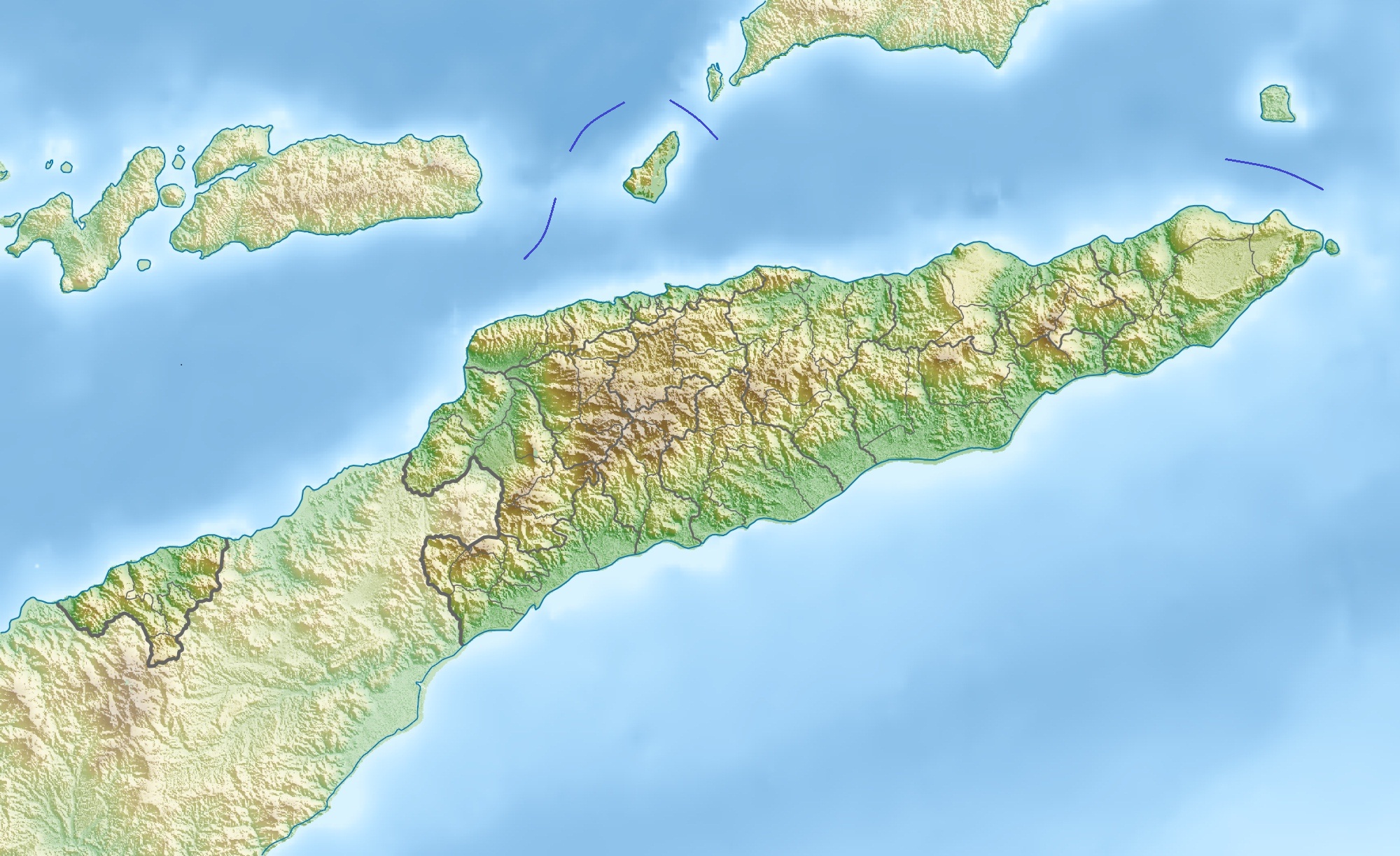
Deutsch: Physische Positionskarte von Osttimor, Grenzen von 2003–2015
Quadratische Plattkarte. Geographische Begrenzung der Karte:
English: Physical location map of East Timor
Equirectangular projection. Geographic limits of the map:
|
| ದಿನಾಂಕ | |
| ಆಕರ | ಸ್ವಂತ ಕೆಲಸ, using map data from administrative map by NordNordWest. The relief was created from SRTM-3 relief data |
| ಕರ್ತೃ | Carport |
| ಅನುಮತಿ (ಈ ಕಡತವನ್ನು ಮರುಬಳಕೆ ಮಾಡಲಾಗುತ್ತಿದೆ) |
This file is licensed under the Creative Commons Attribution 3.0 Unported license.
|
| ಇತರೆ ಆವೃತ್ತಿಗಳು |
Derivative works of this file: Fuiloro Plateau.jpg
|

ಕಡತದ ಇತಿಹಾಸ
ದಿನ/ಕಾಲ ಒತ್ತಿದರೆ ಆ ಸಮಯದಲ್ಲಿ ಈ ಕಡತದ ವಸ್ತುಸ್ಥಿತಿ ತೋರುತ್ತದೆ.
| ದಿನ/ಕಾಲ | ಕಿರುನೋಟ | ಆಯಾಮಗಳು | ಬಳಕೆದಾರ | ಟಿಪ್ಪಣಿ | |
|---|---|---|---|---|---|
| ಪ್ರಸಕ್ತ | ೧೬:೦೬, ೧೭ ನವೆಂಬರ್ ೨೦೧೨ | | ೨,೦೦೦ × ೧,೨೨೩ (೬೫೭ KB) | Jaybear | Borders between islands marked in reference to the map "File:Vychodni Timor.png"; |
| ೧೪:೫೬, ೨೮ ಮಾರ್ಚ್ ೨೦೧೦ |  | ೨,೦೦೦ × ೧,೨೨೩ (೭೪೮ KB) | Carport | {{Information |Description={{de|Physische Positionskarte von {{w|Osttimor|3=de}}}} Quadratische Plattkarte. Geographische Begrenzung der Karte: * N: 7.8° S * S: 10.0° S * W: 123.9° O * O: 127.5° O {{en|Physical location map of {{w|East Timor}}}} Equir |
ಕಡತ ಬಳಕೆ
ಈ ಕೆಳಗಿನ ಪುಟವು ಈ ಚಿತ್ರಕ್ಕೆ ಸಂಪರ್ಕ ಹೊಂದಿದೆ:
ಜಾಗತಿಕ ಕಡತ ಉಪಯೋಗ
ಈ ಕಡತವನ್ನು ಕೆಳಗಿನ ಬೇರೆ ವಿಕಿಗಳೂ ಉಪಯೋಗಿಸುತ್ತಿವೆ:
- ar.wikipedia.org ಮೇಲೆ ಬಳಕೆ
- ast.wikipedia.org ಮೇಲೆ ಬಳಕೆ
- az.wikipedia.org ಮೇಲೆ ಬಳಕೆ
- ba.wikipedia.org ಮೇಲೆ ಬಳಕೆ
- bcl.wikipedia.org ಮೇಲೆ ಬಳಕೆ
- be.wikipedia.org ಮೇಲೆ ಬಳಕೆ
- bg.wikipedia.org ಮೇಲೆ ಬಳಕೆ
- bn.wikipedia.org ಮೇಲೆ ಬಳಕೆ
- bs.wikipedia.org ಮೇಲೆ ಬಳಕೆ
- ca.wikipedia.org ಮೇಲೆ ಬಳಕೆ
- ceb.wikipedia.org ಮೇಲೆ ಬಳಕೆ
- ce.wikipedia.org ಮೇಲೆ ಬಳಕೆ
- ckb.wikipedia.org ಮೇಲೆ ಬಳಕೆ
- cs.wikipedia.org ಮೇಲೆ ಬಳಕೆ
- da.wikipedia.org ಮೇಲೆ ಬಳಕೆ
- de.wikipedia.org ಮೇಲೆ ಬಳಕೆ
- Osttimor
- Jaco (Osttimor)
- Liste der Städte in Osttimor
- Geschichte Osttimors
- Tatamailau
- Matebian
- Benutzer:J. Patrick Fischer/Nützliches
- Cablac
- Vorlage Diskussion:Infobox Berg/Archiv/1
- Vorlage:Positionskarte Osttimor
- Kisar (Indonesien)
- Ira Lalaro
- Maubarasee
- Tasitolu
- Monte Mundo Perdido
- Leolaco
- Wikipedia:Kartenwerkstatt/Positionskarten/Asien
- Curi (Berg)
- Paitchau
- Benutzer:Carport/Galerie
- Legumau
- Straße von Ombai
- Straße von Wetar
ಈ ಫೈಲ್ನ ಹೆಚ್ಚು ಜಾಗತಿಕ ಬಳಕೆಯನ್ನು ವೀಕ್ಷಿಸಿ.