
ಚಿತ್ರ:Dnipropetrovsk province physical map.svg

Size of this PNG preview of this SVG file: ೫೩೧ × ೪೧೪ ಪಿಕ್ಸೆಲ್ಗಳು. ಇತರ ರೆಸಲ್ಯೂಶನ್ಗಳು: ೩೦೮ × ೨೪೦ ಪಿಕ್ಸೆಲ್ಗಳು | ೬೧೬ × ೪೮೦ ಪಿಕ್ಸೆಲ್ಗಳು | ೯೮೫ × ೭೬೮ ಪಿಕ್ಸೆಲ್ಗಳು | ೧,೨೮೦ × ೯೯೮ ಪಿಕ್ಸೆಲ್ಗಳು | ೨,೫೬೦ × ೧,೯೯೬ ಪಿಕ್ಸೆಲ್ಗಳು.
ಮೂಲ ಕಡತ (SVG ಫೈಲು, ಸುಮಾರಾಗಿ ೫೩೧ × ೪೧೪ ಚಿತ್ರಬಿಂದುಗಳು, ಫೈಲಿನ ಗಾತ್ರ: ೧.೮೯ MB)
ಈ ಫೈಲು ವಿಕಿಮೀಡಿಯ ಕಾಮನ್ಸ್ನಲ್ಲಿ ಇರುವುದು. ಅಲ್ಲಿನ ವಿವರಣೆ ಪುಟವನ್ನೇ ಕೆಳಗೆ ತೋರಿಸಲಾಗಿದೆ. ಕಾಮನ್ಸ್ ಕೃತಿಸ್ವಾಮ್ಯತೆಯಿಂದ ಮುಕ್ತ ಫೈಲುಗಳ ಒಂದು ಆಗರ. ಅಲ್ಲಿ ನೀವೂ ಸಹಕರಿಸಬಹುದು. |
ಸಾರಾಂಶ
| ವಿವರ |
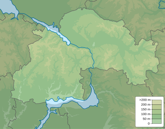
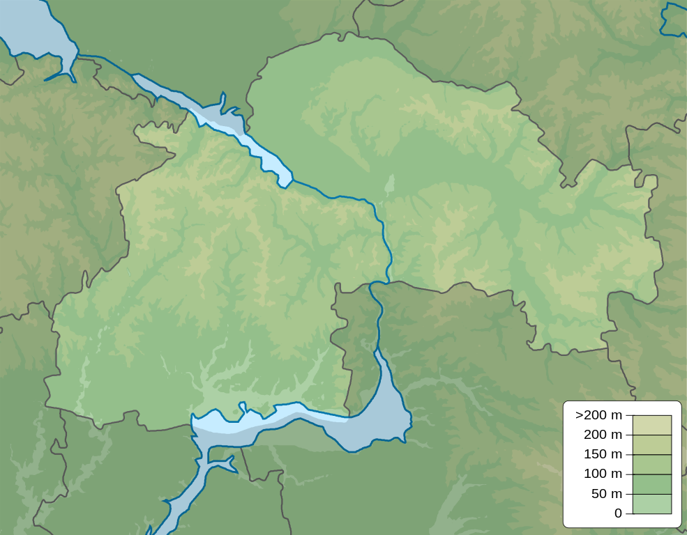
English: Physical map of Dnipropetrovsk Oblast, Ukraine
Русский: Физическая карта Днепропетровская область, Украина |
| ದಿನಾಂಕ | |
| ಆಕರ | ಸ್ವಂತ ಕೆಲಸ |
| ಕರ್ತೃ | Urutseg |
| ಇತರೆ ಆವೃತ್ತಿಗಳು |
 |
ಪರವಾನಗಿ
| I, the copyright holder of this work, release this work into the public domain. This applies worldwide. In some countries this may not be legally possible; if so: I grant anyone the right to use this work for any purpose, without any conditions, unless such conditions are required by law. |
ಕಡತದ ಇತಿಹಾಸ
ದಿನ/ಕಾಲ ಒತ್ತಿದರೆ ಆ ಸಮಯದಲ್ಲಿ ಈ ಕಡತದ ವಸ್ತುಸ್ಥಿತಿ ತೋರುತ್ತದೆ.
| ದಿನ/ಕಾಲ | ಕಿರುನೋಟ | ಆಯಾಮಗಳು | ಬಳಕೆದಾರ | ಟಿಪ್ಪಣಿ | |
|---|---|---|---|---|---|
| ಪ್ರಸಕ್ತ | ೨೩:೩೩, ೧೦ ಡಿಸೆಂಬರ್ ೨೦೧೦ | | ೫೩೧ × ೪೧೪ (೧.೮೯ MB) | Urutseg | == {{int:filedesc}} == {{Information |Description={{en|1=Physical map of Dnipropetrivsk province, Ukraine}} {{ru|1=Физическая карта Днепропетровской области, Украина}} |Source={{own}} |Author=[[User:Urutseg|Uru |
ಕಡತ ಬಳಕೆ
ಈ ಕೆಳಗಿನ ಪುಟವು ಈ ಚಿತ್ರಕ್ಕೆ ಸಂಪರ್ಕ ಹೊಂದಿದೆ:
ಜಾಗತಿಕ ಕಡತ ಉಪಯೋಗ
ಈ ಕಡತವನ್ನು ಕೆಳಗಿನ ಬೇರೆ ವಿಕಿಗಳೂ ಉಪಯೋಗಿಸುತ್ತಿವೆ:
- ar.wikipedia.org ಮೇಲೆ ಬಳಕೆ
- be.wikipedia.org ಮೇಲೆ ಬಳಕೆ
- bg.wikipedia.org ಮೇಲೆ ಬಳಕೆ
- ceb.wikipedia.org ಮೇಲೆ ಬಳಕೆ
- ce.wikipedia.org ಮೇಲೆ ಬಳಕೆ
- da.wikipedia.org ಮೇಲೆ ಬಳಕೆ
- de.wikipedia.org ಮೇಲೆ ಬಳಕೆ
- Vorlage:Positionskarte Ukraine Oblast Dnipropetrowsk
- Schowta
- Saksahan
- Schlacht bei Schowti Wody
- Krywbas
- Karatschuniwka-Stausee
- Makorty-Stausee
- Chrystoforiwka-Stausee
- Dnepr-Krywyj-Rih-Kanal
- Klosterinsel
- Mokra Sura
- Kamjanka (Basawluk)
- Samotkan (Fluss)
- Dnepr-Becken
- Benutzer:Francis McLloyd/Becken/Dnepr-Becken
- Kiltschen
- en.wikipedia.org ಮೇಲೆ ಬಳಕೆ
- Kryvyi Rih
- Dnipro
- Nikopol, Ukraine
- Vilnohirsk
- Tomakivka
- Module:Location map/data/Ukraine Dnipropetrovsk Oblast/doc
- Petropavlivka, Dnipropetrovsk Oblast
- Module:Location map/data/Ukraine Dnipropetrovsk Oblast
- Kurylivka, Dnipropetrovsk Oblast
- Malomykolaivka, Dnipropetrovsk Oblast
- Surs'ko-Mykhailivka
- Ternove, Dnipropetrovsk Oblast
- Stepove, Velykomykhailivka rural hromada, Synelnykove Raion, Dnipropetrovsk Oblast
- Zaporizke, Velykomykhailivka rural hromada, Synelnykove Raion, Dnipropetrovsk Oblast
- Kalynivske, Velykomykhailivka rural hromada, Synelnykove Raion, Dnipropetrovsk Oblast
- Novoheorhiivka, Synelnykove Raion, Dnipropetrovsk Oblast
- Voronove, Dnipropetrovsk Oblast
- Osokorivka, Dnipropetrovsk Oblast
- eo.wikipedia.org ಮೇಲೆ ಬಳಕೆ
ಈ ಫೈಲ್ನ ಹೆಚ್ಚು ಜಾಗತಿಕ ಬಳಕೆಯನ್ನು ವೀಕ್ಷಿಸಿ.