
ಚಿತ್ರ:Cumbria UK relief location map.jpg
ಈ ಮುನ್ನೋಟ ಗಾತ್ರ:೫೦೮ × ೫೯೯ ಪಿಕ್ಸೆಲ್ಗಳು. ಇತರ ರೆಸಲ್ಯೂಶನ್ಗಳು: ೨೦೩ × ೨೪೦ ಪಿಕ್ಸೆಲ್ಗಳು | ೪೦೭ × ೪೮೦ ಪಿಕ್ಸೆಲ್ಗಳು | ೬೫೧ × ೭೬೮ ಪಿಕ್ಸೆಲ್ಗಳು | ೮೬೮ × ೧,೦೨೪ ಪಿಕ್ಸೆಲ್ಗಳು | ೨,೦೦೩ × ೨,೩೬೩ ಪಿಕ್ಸೆಲ್ಗಳು.
ಮೂಲ ಕಡತ (೨,೦೦೩ × ೨,೩೬೩ ಚಿತ್ರಬಿಂದು, ಫೈಲಿನ ಗಾತ್ರ: ೭೦೦ KB, MIME ಪ್ರಕಾರ: image/jpeg)
ಈ ಫೈಲು ವಿಕಿಮೀಡಿಯ ಕಾಮನ್ಸ್ನಲ್ಲಿ ಇರುವುದು. ಅಲ್ಲಿನ ವಿವರಣೆ ಪುಟವನ್ನೇ ಕೆಳಗೆ ತೋರಿಸಲಾಗಿದೆ. ಕಾಮನ್ಸ್ ಕೃತಿಸ್ವಾಮ್ಯತೆಯಿಂದ ಮುಕ್ತ ಫೈಲುಗಳ ಒಂದು ಆಗರ. ಅಲ್ಲಿ ನೀವೂ ಸಹಕರಿಸಬಹುದು. |
| ವಿವರ |
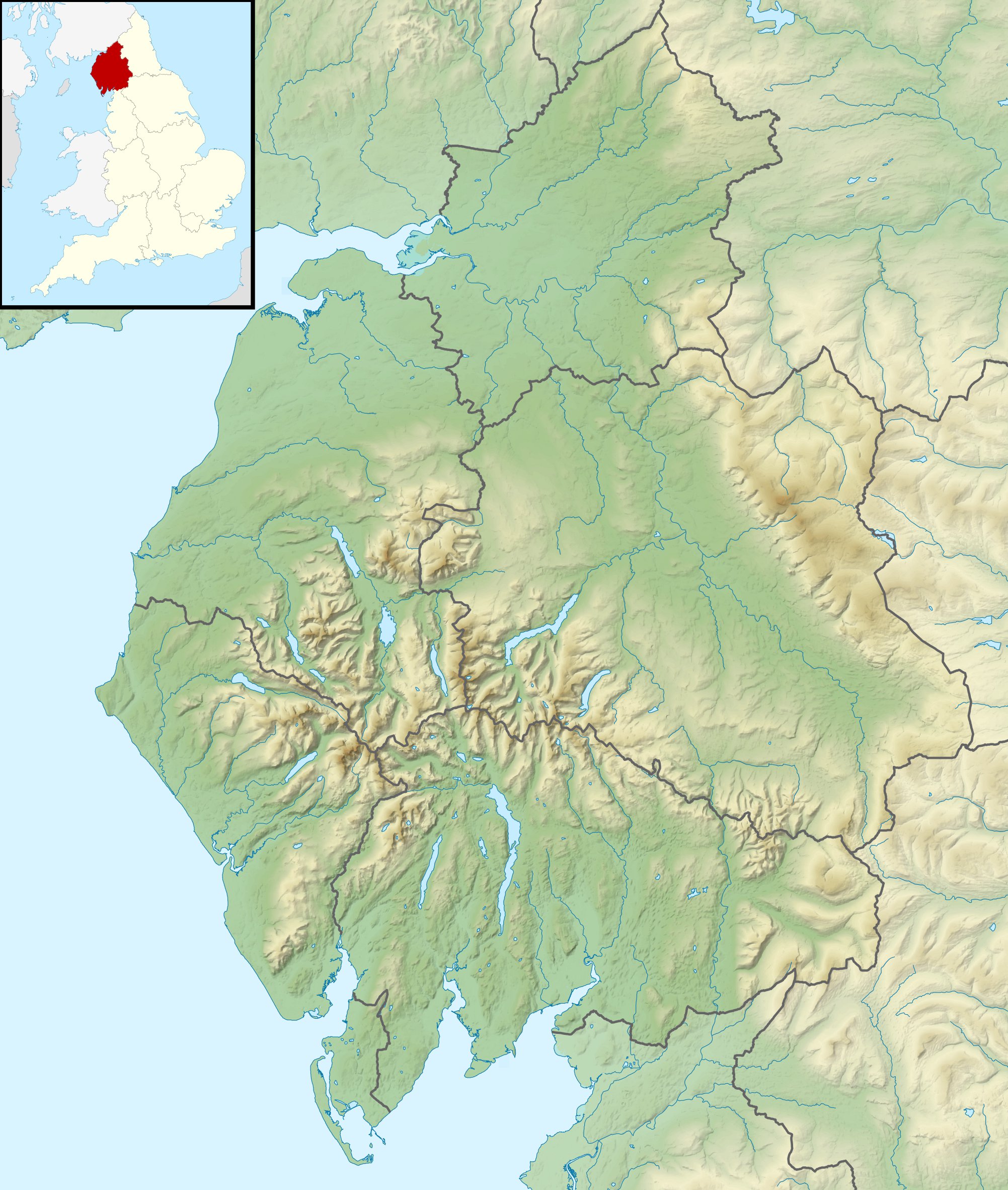
Relief map of Cumbria, UK. Equirectangular map projection on WGS 84 datum, with N/S stretched 170% Geographic limits:
|
| ದಿನಾಂಕ | |
| ಆಕರ |
|
| ಕರ್ತೃ | Nilfanion, created using Ordnance Survey data |
| ಅನುಮತಿ (ಈ ಕಡತವನ್ನು ಮರುಬಳಕೆ ಮಾಡಲಾಗುತ್ತಿದೆ) |
ಈ ಕಡತ ಕ್ರಿಯೇಟಿವ್ ಕಾಮನ್ಸ್ Attribution
-Share Alike 3.0 Unported ಪರವಾನಗಿ ಹೊಂದಿದೆ. ವೈಶಿಷ್ಟ್ಯ: Contains Ordnance Survey data © Crown copyright and database right
|
| ಇತರೆ ಆವೃತ್ತಿಗಳು | File:Cumbria UK district map (blank).svg - Blank map |
.svg)
ಕಡತದ ಇತಿಹಾಸ
ದಿನ/ಕಾಲ ಒತ್ತಿದರೆ ಆ ಸಮಯದಲ್ಲಿ ಈ ಕಡತದ ವಸ್ತುಸ್ಥಿತಿ ತೋರುತ್ತದೆ.
| ದಿನ/ಕಾಲ | ಕಿರುನೋಟ | ಆಯಾಮಗಳು | ಬಳಕೆದಾರ | ಟಿಪ್ಪಣಿ | |
|---|---|---|---|---|---|
| ಪ್ರಸಕ್ತ | ೦೬:೫೪, ೨೯ ನವೆಂಬರ್ ೨೦೧೧ | | ೨,೦೦೩ × ೨,೩೬೩ (೭೦೦ KB) | Nilfanion | {{Information |Description=Relief map of Cumbria, UK. Equirectangular map projection on WGS 84 datum, with N/S stretched 170% Geographic limits: *West: 3.80W *East: 2.10W *North: 55.20N *South: 54.02N |Source=[[w:Ordnance Survey|Ordnance S |
ಕಡತ ಬಳಕೆ
ಈ ಕೆಳಗಿನ ಪುಟವು ಈ ಚಿತ್ರಕ್ಕೆ ಸಂಪರ್ಕ ಹೊಂದಿದೆ:
ಜಾಗತಿಕ ಕಡತ ಉಪಯೋಗ
ಈ ಕಡತವನ್ನು ಕೆಳಗಿನ ಬೇರೆ ವಿಕಿಗಳೂ ಉಪಯೋಗಿಸುತ್ತಿವೆ:
- ar.wikipedia.org ಮೇಲೆ ಬಳಕೆ
- arz.wikipedia.org ಮೇಲೆ ಬಳಕೆ
- bg.wikipedia.org ಮೇಲೆ ಬಳಕೆ
- ca.wikipedia.org ಮೇಲೆ ಬಳಕೆ
- ceb.wikipedia.org ಮೇಲೆ ಬಳಕೆ
- en.wikipedia.org ಮೇಲೆ ಬಳಕೆ
- River Derwent, Cumbria
- Morecambe Bay
- Cross Fell
- River Leven, Cumbria
- River Esk (Ravenglass)
- River Cocker, Cumbria
- Firbank Fell
- Green Hill (Lancashire)
- Haweswater Beck
- River Mite
- Thurstonfield Lough
- River Greta, Cumbria
- Rusland Pool
- River Glenderamackin
- River Bela
- Peasey Beck
- Stainton Beck
- River Ellen
- Kershope Burn
- River Caldew
- River Petteril
- River Dee, Cumbria
- Clough River
- Solway Aviation Museum
- Black Fell (Pennines)
- Seathwaite Tarn
- Appleby Fells
- Murton Fell
- Moss Eccles Tarn
- Little Langdale
- Wikipedia talk:UK Wikipedians' notice board/Archive 15
- Killhope Cross
- Template:Infobox mountain pass/testcases
- Alcock Tarn
- Roe Beck
- Cam Beck
- Module:Location map/data/United Kingdom Cumbria
- Module:Location map/data/Cumbria
ಈ ಫೈಲ್ನ ಹೆಚ್ಚು ಜಾಗತಿಕ ಬಳಕೆಯನ್ನು ವೀಕ್ಷಿಸಿ.