
ಚಿತ್ರ:China Xinjiang location map.svg

ಮೂಲ ಕಡತ (SVG ಫೈಲು, ಸುಮಾರಾಗಿ ೨,೨೨೦ × ೧,೯೩೯ ಚಿತ್ರಬಿಂದುಗಳು, ಫೈಲಿನ ಗಾತ್ರ: ೪೬೪ KB)
ಈ ಫೈಲು ವಿಕಿಮೀಡಿಯ ಕಾಮನ್ಸ್ನಲ್ಲಿ ಇರುವುದು. ಅಲ್ಲಿನ ವಿವರಣೆ ಪುಟವನ್ನೇ ಕೆಳಗೆ ತೋರಿಸಲಾಗಿದೆ. ಕಾಮನ್ಸ್ ಕೃತಿಸ್ವಾಮ್ಯತೆಯಿಂದ ಮುಕ್ತ ಫೈಲುಗಳ ಒಂದು ಆಗರ. ಅಲ್ಲಿ ನೀವೂ ಸಹಕರಿಸಬಹುದು. |


|
This file requires updating because: The China-Tajikistan border has changed, Kunyu, Xinjiang is not included, Aksai Chin & the Trans-Karakoram Tract (the China-India disputed areas administered by China as part of Xinjiang) probably shouldn't be the same color as Tibet (ought to be slashed white & grey lines or something similar), and etc. other problems In doing so, you could add a timestamp to the file.
|
ಸಾರಾಂಶ
| ವಿವರ |
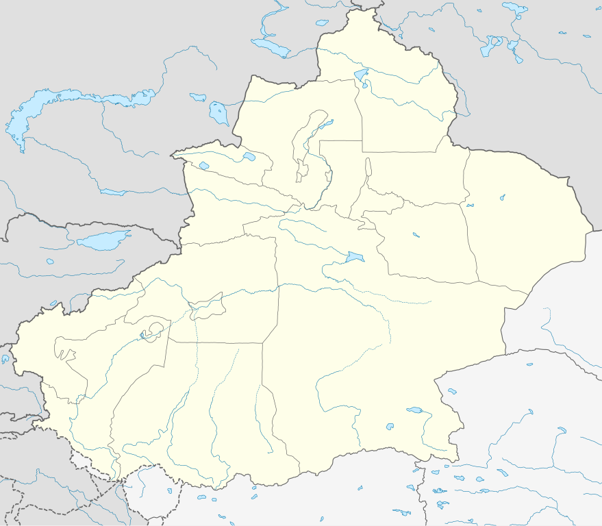
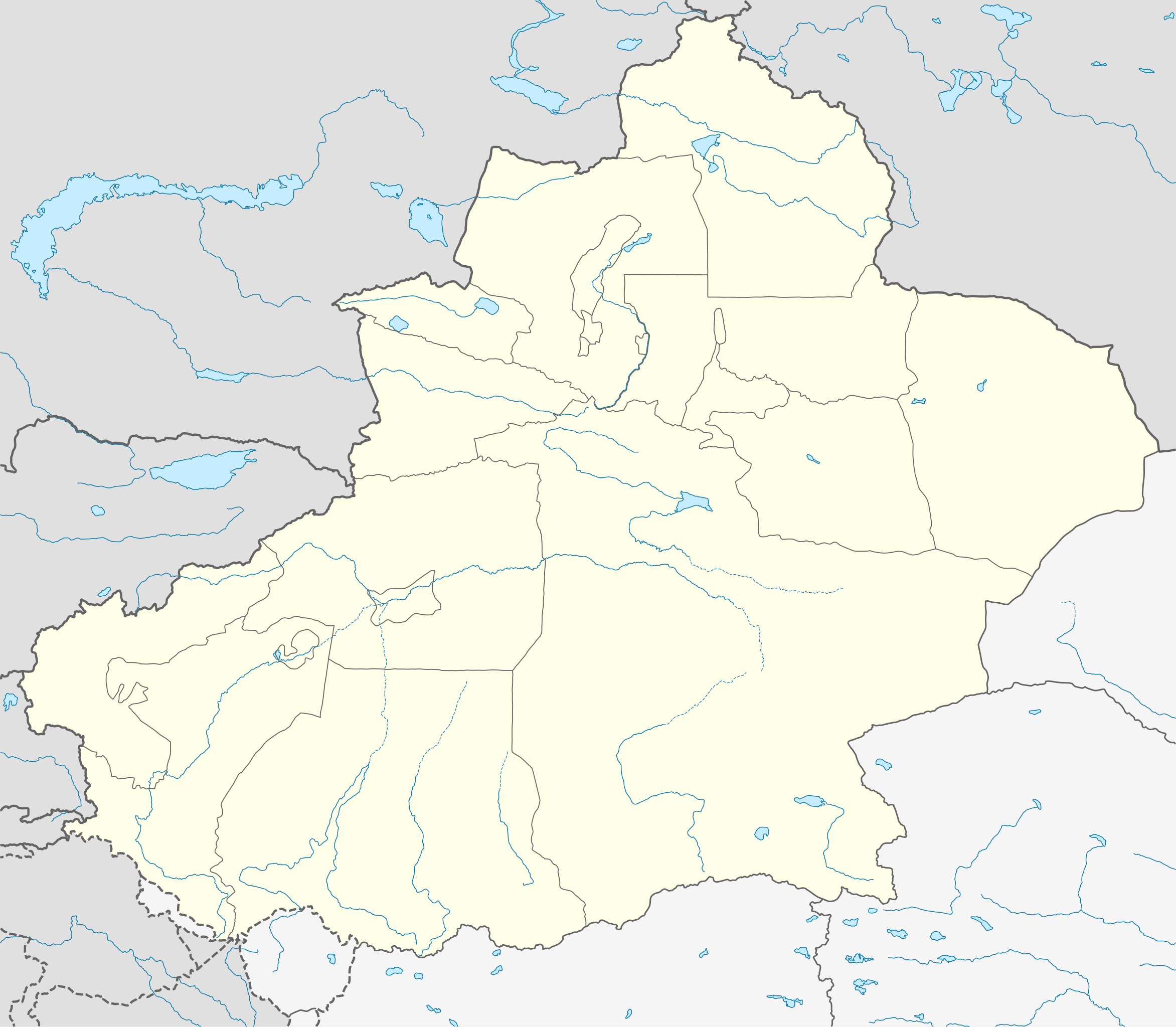
Deutsch: Positionskarte von Xinjiang, Volksrepublik China im Jahr 2010
Quadratische Plattkarte, N-S-Streckung 135 %. Geographische Begrenzung der Karte:
English: Location map of Xinjiang, People's Republic of China, in 2010
Equirectangular projection, N/S stretching 135 %. Geographic limits of the map:
|
||
| ದಿನಾಂಕ | |||
| ಆಕರ |
ಸ್ವಂತ ಕೆಲಸ, using
|
||
| ಕರ್ತೃ | NordNordWest | ||
| ಅನುಮತಿ (ಈ ಕಡತವನ್ನು ಮರುಬಳಕೆ ಮಾಡಲಾಗುತ್ತಿದೆ) |
This file is licensed under the Creative Commons Attribution-Share Alike 3.0 Germany license.
 This file is licensed under the Creative Commons Attribution-Share Alike 3.0 Germany license.
|
||
| ಇತರೆ ಆವೃತ್ತಿಗಳು |
|
||
| SVG genesis | This W3C-invalid map was created with Adobe Illustrator.
|


ಕಡತದ ಇತಿಹಾಸ
ದಿನ/ಕಾಲ ಒತ್ತಿದರೆ ಆ ಸಮಯದಲ್ಲಿ ಈ ಕಡತದ ವಸ್ತುಸ್ಥಿತಿ ತೋರುತ್ತದೆ.
| ದಿನ/ಕಾಲ | ಕಿರುನೋಟ | ಆಯಾಮಗಳು | ಬಳಕೆದಾರ | ಟಿಪ್ಪಣಿ | |
|---|---|---|---|---|---|
| ಪ್ರಸಕ್ತ | ೧೨:೫೩, ೧೦ ಜೂನ್ ೨೦೨೦ | | ೨,೨೨೦ × ೧,೯೩೯ (೪೬೪ KB) | NordNordWest | corr |
| ೦೩:೪೬, ೧೦ ಜೂನ್ ೨೦೨೦ |  | ೨,೨೨೦ × ೧,೯೩೯ (೪೭೦ KB) | Bjh21 | Reverted to version as of 13:31, 9 June 2020 (UTC): COM:UPLOADWAR; at least two users are of the opinion that this change is not minor, and I'm coming close to that view myself | |
| ೦೩:೩೯, ೧೦ ಜೂನ್ ೨೦೨೦ |  | ೨,೨೨೦ × ೧,೯೩೯ (೮೨೦ KB) | Geographyinitiative | Reverted to version as of 01:15, 9 June 2020 (UTC) Incorrect map is incorrect | |
| ೧೯:೦೧, ೯ ಜೂನ್ ೨೦೨೦ |  | ೨,೨೨೦ × ೧,೯೩೯ (೪೭೦ KB) | NordNordWest | Reverted to version as of 15:35, 28 December 2012 (UTC) again: only vector data in this svg please | |
| ೦೬:೪೫, ೯ ಜೂನ್ ೨೦೨೦ |  | ೨,೨೨೦ × ೧,೯೩೯ (೮೨೦ KB) | Geographyinitiative | Reverted to version as of 05:18, 13 April 2020 (UTC) | |
| ೦೨:೧೮, ೨೫ ಮೇ ೨೦೨೦ |  | ೨,೨೨೦ × ೧,೯೩೯ (೪೭೦ KB) | Roy17 | Reverted to version as of 15:35, 28 December 2012 (UTC) | |
| ೧೦:೪೮, ೧೩ ಏಪ್ರಿಲ್ ೨೦೨೦ |  | ೨,೨೨೦ × ೧,೯೩೯ (೮೨೦ KB) | Geographyinitiative | Reverted to version as of 06:36, 29 January 2019 (UTC) See talk page | |
| ೧೬:೧೧, ೨೯ ಜನವರಿ ೨೦೧೯ |  | ೨,೨೨೦ × ೧,೯೩೯ (೪೭೦ KB) | NordNordWest | Reverted to version as of 15:35, 28 December 2012 (UTC); only vector data in this svg please | |
| ೧೨:೦೬, ೨೯ ಜನವರಿ ೨೦೧೯ |  | ೨,೨೨೦ × ೧,೯೩೯ (೮೨೦ KB) | 复旦大学张超 | edit | |
| ೨೧:೦೫, ೨೮ ಡಿಸೆಂಬರ್ ೨೦೧೨ |  | ೨,೨೨೦ × ೧,೯೩೯ (೪೭೦ KB) | NordNordWest | upd |
ಕಡತ ಬಳಕೆ
ಈ ಕೆಳಗಿನ ಪುಟವು ಈ ಚಿತ್ರಕ್ಕೆ ಸಂಪರ್ಕ ಹೊಂದಿದೆ:
ಜಾಗತಿಕ ಕಡತ ಉಪಯೋಗ
ಈ ಕಡತವನ್ನು ಕೆಳಗಿನ ಬೇರೆ ವಿಕಿಗಳೂ ಉಪಯೋಗಿಸುತ್ತಿವೆ:
- ar.wikipedia.org ಮೇಲೆ ಬಳಕೆ
- ba.wikipedia.org ಮೇಲೆ ಬಳಕೆ
- bg.wikipedia.org ಮೇಲೆ ಬಳಕೆ
- ceb.wikipedia.org ಮೇಲೆ ಬಳಕೆ
- ce.wikipedia.org ಮೇಲೆ ಬಳಕೆ
- ckb.wikipedia.org ಮೇಲೆ ಬಳಕೆ
- cs.wikipedia.org ಮೇಲೆ ಬಳಕೆ
- en.wikipedia.org ಮೇಲೆ ಬಳಕೆ
- eo.wikipedia.org ಮೇಲೆ ಬಳಕೆ
- es.wikipedia.org ಮೇಲೆ ಬಳಕೆ
- et.wikipedia.org ಮೇಲೆ ಬಳಕೆ
- fa.wikipedia.org ಮೇಲೆ ಬಳಕೆ
- incubator.wikimedia.org ಮೇಲೆ ಬಳಕೆ
- kbd.wikipedia.org ಮೇಲೆ ಬಳಕೆ
- ko.wikipedia.org ಮೇಲೆ ಬಳಕೆ
- mk.wikipedia.org ಮೇಲೆ ಬಳಕೆ
- or.wikipedia.org ಮೇಲೆ ಬಳಕೆ
- pl.wikibooks.org ಮೇಲೆ ಬಳಕೆ
- pnb.wikipedia.org ಮೇಲೆ ಬಳಕೆ
- ps.wikipedia.org ಮೇಲೆ ಬಳಕೆ
- simple.wikipedia.org ಮೇಲೆ ಬಳಕೆ
- su.wikipedia.org ಮೇಲೆ ಬಳಕೆ
- tr.wikipedia.org ಮೇಲೆ ಬಳಕೆ
- vi.wikipedia.org ಮೇಲೆ ಬಳಕೆ
- war.wikipedia.org ಮೇಲೆ ಬಳಕೆ
- xmf.wikipedia.org ಮೇಲೆ ಬಳಕೆ