ಚಿತ್ರ:Chicago Millennium Park Exelon Pavilions.png

Page contents not supported in other languages.
ವಿಕಿಪೀಡಿಯದಿಂದ, ಇದು ಮುಕ್ತ ಹಾಗೂ ಸ್ವತಂತ್ರ ವಿಶ್ವಕೋಶ

ಮೂಲ ಕಡತ(೭೫೫ × ೭೩೩ ಚಿತ್ರಬಿಂದು, ಫೈಲಿನ ಗಾತ್ರ: ೩೯೮ KB, MIME ಪ್ರಕಾರ: image/png)

Description
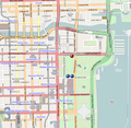
This map of Millenium Park area, Chicago, Illinois, USA (Dots added for the positions of the Exelon Pavilions - I used File:Red pog.svg and File:Blue pog.svg) was created from OpenStreetMap project data, collected by the community. This map may be incomplete, and may contain errors. Don't rely solely on it for navigation.
ದಿನಾಂಕ (see file history)
ಆಕರ openstreetmap.org
ಸೃಷ್ಟಿಕರ್ತ
Dr. Blofeld, dots added by Ruhrfisch (talk)
OpenStreetMap contributors
ಅನುಮತಿ
(ಈ ಕಡತವನ್ನು ಮರುಬಳಕೆ ಮಾಡಲಾಗುತ್ತಿದೆ)
OpenStreetMap data and maps are licensed under the Creative Commons Attribution-ShareAlike 2.0 license (CC-BY-SA 2.0).
w:en:Creative Commons
ವೈಶಿಷ್ಟ್ಯ ಇರುವುದರಂತೆಯೇ ಹಂಚು
This file is licensed under the Creative Commons Attribution-Share Alike 2.0 Generic license.
ನೀವು ಮುಕ್ತ:
  • ಹಂಚಿಕೆಗೆ – ಕೆಲಸವನ್ನು ನಕಲು ಮಾಡಲು, ವಿತರಣೆ ಮತ್ತು ಸಾಗಿಸಲು
  • ರೀಮಿಕ್ಸ್ ಮಾಡಲು – ಕೆಲಸವನ್ನು ಬಳಸಿಕೊಳ್ಳಲು
ಈ ಕೆಳಗಿನ ಷರತ್ತುಗಳಲ್ಲಿ:
  • ವೈಶಿಷ್ಟ್ಯ – ನೀವು ಸೂಕ್ತವಾದ ಕ್ರೆಡಿಟ್ ನೀಡಬೇಕು, ಪರವಾನಗಿಗೆ ಲಿಂಕ್ ಅನ್ನು ಒದಗಿಸಬೇಕು ಮತ್ತು ಯಾವುದೇ ಬದಲಾವಣೆಗಳನ್ನು ಮಾಡಿದ್ದರೆ ಸೂಚಿಸಬೇಕು. ನೀವು ಯಾವುದೇ ಸಮಂಜಸವಾದ ರೀತಿಯಲ್ಲಿ ಮಾಡಬಹುದು, ಆದರೆ ಪರವಾನಗಿದಾರರು ನಿಮ್ಮನ್ನು ಅಥವಾ ನಿಮ್ಮ ಯಾವುದೇ ಬಳಕೆಯನ್ನು ಅನುಮೋದಿಸಿದಂತೆ ರೀತಿಯಲ್ಲಿ ಉಪಯೋಗಿಸಬಾರದು.
  • ಇರುವುದರಂತೆಯೇ ಹಂಚು – ನೀವು ರೀಮಿಕ್ಸ್ ಮಾಡಿದರೆ, ರೂಪಾಂತರಗೊಳಿಸಿದರೆ ಅಥವಾ ವಸ್ತುವಿನ ಮೇಲೆ ನಿರ್ಮಿಸಿದರೆ, ನಿಮ್ಮ ಕೊಡುಗೆಗಳನ್ನು ನೀವು ಮೂಲದಂತೆ ಅದೇ ಅಥವಾ ಹೊಂದಾಣಿಕೆಯ ಪರವಾನಗಿ ಅಡಿಯಲ್ಲಿ ವಿತರಿಸಬೇಕು.
 Geotemporal data
Bounding box
N: 41.89254°N
W: 87.63585°W E: 87.60924°W
S: 41.8733°N
Georeferencing Georeference the map in Wikimaps Warper If inappropriate please set warp_status = skip to hide.
ಇತರೆ ಆವೃತ್ತಿಗಳು
(no dots)

Captions

Add a one-line explanation of what this file represents

Items portrayed in this file

depicts ಇಂಗ್ಲಿಷ್

copyright status ಇಂಗ್ಲಿಷ್

copyrighted ಇಂಗ್ಲಿಷ್

media type ಇಂಗ್ಲಿಷ್

image/png

checksum ಇಂಗ್ಲಿಷ್

b6746e35115205ee623d5be2868d808dc1367da8

determination method ಇಂಗ್ಲಿಷ್: SHA-1 ಇಂಗ್ಲಿಷ್

data size ಇಂಗ್ಲಿಷ್

೪,೦೭,೧೦೦ byte

height ಇಂಗ್ಲಿಷ್

೭೩೩ pixel

width ಇಂಗ್ಲಿಷ್

೭೫೫ pixel

ಕಡತದ ಇತಿಹಾಸ

ದಿನ/ಕಾಲ ಒತ್ತಿದರೆ ಆ ಸಮಯದಲ್ಲಿ ಈ ಕಡತದ ವಸ್ತುಸ್ಥಿತಿ ತೋರುತ್ತದೆ.

ದಿನ/ಕಾಲಕಿರುನೋಟಆಯಾಮಗಳುಬಳಕೆದಾರಟಿಪ್ಪಣಿ
ಪ್ರಸಕ್ತ೨೧:೫೫, ೩ ಸೆಪ್ಟೆಂಬರ್ ೨೦೧೦೨೧:೫೫, ೩ ಸೆಪ್ಟೆಂಬರ್ ೨೦೧೦ ವರೆಗಿನ ಆವೃತ್ತಿಯ ಕಿರುನೋಟ೭೫೫ × ೭೩೩ (೩೯೮ KB)RuhrfischRemove white space - whoops
೨೧:೫೨, ೩ ಸೆಪ್ಟೆಂಬರ್ ೨೦೧೦೨೧:೫೨, ೩ ಸೆಪ್ಟೆಂಬರ್ ೨೦೧೦ ವರೆಗಿನ ಆವೃತ್ತಿಯ ಕಿರುನೋಟ೧,೬೮೦ × ೧,೦೫೦ (೪೪೪ KB)RuhrfischDOts 2 px bigger (22 px each)
೨೧:೩೬, ೩ ಸೆಪ್ಟೆಂಬರ್ ೨೦೧೦೨೧:೩೬, ೩ ಸೆಪ್ಟೆಂಬರ್ ೨೦೧೦ ವರೆಗಿನ ಆವೃತ್ತಿಯ ಕಿರುನೋಟ೭೫೫ × ೭೩೩ (೩೯೭ KB)RuhrfischBigger dots (20 px wide 20px and 20px) All other information is the same
೨೧:೨೪, ೧ ಸೆಪ್ಟೆಂಬರ್ ೨೦೧೦೨೧:೨೪, ೧ ಸೆಪ್ಟೆಂಬರ್ ೨೦೧೦ ವರೆಗಿನ ಆವೃತ್ತಿಯ ಕಿರುನೋಟ೭೫೫ × ೭೩೩ (೩೯೭ KB)Ruhrfisch{{Information |Description={{en|1=Map of Millenium Park area, Chicago, Illinois, USA. Dots added for the positions of the Exelon Pavilions. Geographic limits of the map: * N: 41.89254° * S: 41.8733° * W: -87.63585° * E: -87.60924° {{CC-BY-SA 2.0}

ಈ ಕೆಳಗಿನ ಪುಟವು ಈ ಚಿತ್ರಕ್ಕೆ ಸಂಪರ್ಕ ಹೊಂದಿದೆ:

ಜಾಗತಿಕ ಕಡತ ಉಪಯೋಗ

ಈ ಕಡತವನ್ನು ಕೆಳಗಿನ ಬೇರೆ ವಿಕಿಗಳೂ ಉಪಯೋಗಿಸುತ್ತಿವೆ: