
ಚಿತ್ರ:Central African Republic-CIA WFB Map.png
ಇದಕ್ಕಿಂತ ಹೆಚ್ಚಿನ ವಿವರವಾದ ನೋಟ ಇಲ್ಲ.
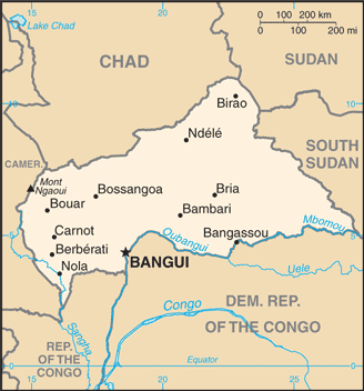
Central_African_Republic-CIA_WFB_Map.png (೩೨೮ × ೩೫೨ ಚಿತ್ರಬಿಂದು, ಫೈಲಿನ ಗಾತ್ರ: ೪೯ KB, MIME ಪ್ರಕಾರ: image/png)
ಈ ಫೈಲು ವಿಕಿಮೀಡಿಯ ಕಾಮನ್ಸ್ನಲ್ಲಿ ಇರುವುದು. ಅಲ್ಲಿನ ವಿವರಣೆ ಪುಟವನ್ನೇ ಕೆಳಗೆ ತೋರಿಸಲಾಗಿದೆ. ಕಾಮನ್ಸ್ ಕೃತಿಸ್ವಾಮ್ಯತೆಯಿಂದ ಮುಕ್ತ ಫೈಲುಗಳ ಒಂದು ಆಗರ. ಅಲ್ಲಿ ನೀವೂ ಸಹಕರಿಸಬಹುದು. |
ಸಾರಾಂಶ
| ವಿವರ | Central African Republic map from CIA World Factbook, converted from original GIF format (July 2011 version showing South Sudan) |
| ದಿನಾಂಕ | |
| ಆಕರ |
CIA World Factbook |
| ಕರ್ತೃ | United States Central Intelligence Agency |
| ಇತರೆ ಆವೃತ್ತಿಗಳು |
ಪರವಾನಗಿ
This image is in the public domain because it contains materials that originally came from the United States Central Intelligence Agency's World Factbook.
|
 |
Derivative works
Derivatives of 2011 map (showing South Sudan):
-
 Central African Republic-map-blank.png
 -
 Republique centrafricaine carte.gif
français -
 Centra Afrika Respubliko.png
Esperanto


Derivatives of 2004 map (not showing South Sudan):
-
 Central African Republic CIA map PL.jpg
polski -
 Mapa stredoafricke rep.png
čeština -
 SAR-kaart.png
Afrikaans


.png)
ಕಡತದ ಇತಿಹಾಸ
ದಿನ/ಕಾಲ ಒತ್ತಿದರೆ ಆ ಸಮಯದಲ್ಲಿ ಈ ಕಡತದ ವಸ್ತುಸ್ಥಿತಿ ತೋರುತ್ತದೆ.
| ದಿನ/ಕಾಲ | ಕಿರುನೋಟ | ಆಯಾಮಗಳು | ಬಳಕೆದಾರ | ಟಿಪ್ಪಣಿ | |
|---|---|---|---|---|---|
| ಪ್ರಸಕ್ತ | ೦೫:೩೮, ೧೩ ಜುಲೈ ೨೦೧೧ | | ೩೨೮ × ೩೫೨ (೪೯ KB) | Béka~commonswiki | new version with South Sudan, from CIA |
| ೧೪:೪೨, ೨೭ ಮಾರ್ಚ್ ೨೦೦೫ |  | ೩೨೬ × ೩೫೦ (೧೧ KB) | Wolfman~commonswiki | {{CIA-map}} |
ಕಡತ ಬಳಕೆ
ಈ ಕೆಳಗಿನ 2 ಪುಟಗಳು ಈ ಚಿತ್ರಕ್ಕೆ ಸಂಪರ್ಕ ಹೊಂದಿವೆ:
ಜಾಗತಿಕ ಕಡತ ಉಪಯೋಗ
ಈ ಕಡತವನ್ನು ಕೆಳಗಿನ ಬೇರೆ ವಿಕಿಗಳೂ ಉಪಯೋಗಿಸುತ್ತಿವೆ:
- ar.wikipedia.org ಮೇಲೆ ಬಳಕೆ
- bcl.wikipedia.org ಮೇಲೆ ಬಳಕೆ
- be-tarask.wikipedia.org ಮೇಲೆ ಬಳಕೆ
- bs.wikipedia.org ಮೇಲೆ ಬಳಕೆ
- ca.wikipedia.org ಮೇಲೆ ಬಳಕೆ
- ckb.wikipedia.org ಮೇಲೆ ಬಳಕೆ
- cy.wikipedia.org ಮೇಲೆ ಬಳಕೆ
- da.wikipedia.org ಮೇಲೆ ಬಳಕೆ
- de.wikipedia.org ಮೇಲೆ ಬಳಕೆ
- de.wikinews.org ಮೇಲೆ ಬಳಕೆ
- en.wikipedia.org ಮೇಲೆ ಬಳಕೆ
- List of cities in the Central African Republic
- Petroleum industry in Nigeria
- Saint-Sylvestre coup d'état
- Alexandre Banza
- Jean Izamo
- United Nations Security Council Resolution 1271
- Module:Location map/data/Central African Republic/doc
- User:Mhs79/sandbox
- United Nations Mission in the Central African Republic
- Module:Location map/data/Central African Republic
- Central African Republic–Sudan border
- en.wikinews.org ಮೇಲೆ ಬಳಕೆ
- en.wikisource.org ಮೇಲೆ ಬಳಕೆ
- eo.wikipedia.org ಮೇಲೆ ಬಳಕೆ
- es.wikipedia.org ಮೇಲೆ ಬಳಕೆ
- eu.wikipedia.org ಮೇಲೆ ಬಳಕೆ
- fa.wikipedia.org ಮೇಲೆ ಬಳಕೆ
- fi.wikipedia.org ಮೇಲೆ ಬಳಕೆ
- fi.wikivoyage.org ಮೇಲೆ ಬಳಕೆ
- fr.wikipedia.org ಮೇಲೆ ಬಳಕೆ
- fr.wikinews.org ಮೇಲೆ ಬಳಕೆ
- gd.wikipedia.org ಮೇಲೆ ಬಳಕೆ
- hu.wikipedia.org ಮೇಲೆ ಬಳಕೆ
ಈ ಫೈಲ್ನ ಹೆಚ್ಚು ಜಾಗತಿಕ ಬಳಕೆಯನ್ನು ವೀಕ್ಷಿಸಿ.