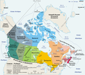
ಚಿತ್ರ:Carte administrative du Canada.png

ಈ ಮುನ್ನೋಟ ಗಾತ್ರ:೬೮೦ × ೫೯೯ ಪಿಕ್ಸೆಲ್ಗಳು. ಇತರ ರೆಸಲ್ಯೂಶನ್ಗಳು: ೨೭೨ × ೨೪೦ ಪಿಕ್ಸೆಲ್ಗಳು | ೫೪೫ × ೪೮೦ ಪಿಕ್ಸೆಲ್ಗಳು | ೮೭೨ × ೭೬೮ ಪಿಕ್ಸೆಲ್ಗಳು | ೧,೧೬೨ × ೧,೦೨೪ ಪಿಕ್ಸೆಲ್ಗಳು | ೧,೨೮೦ × ೧,೧೨೮ ಪಿಕ್ಸೆಲ್ಗಳು.
ಮೂಲ ಕಡತ (೧,೨೮೦ × ೧,೧೨೮ ಚಿತ್ರಬಿಂದು, ಫೈಲಿನ ಗಾತ್ರ: ೫೨೨ KB, MIME ಪ್ರಕಾರ: image/png)
ಕಡತದ ಇತಿಹಾಸ
ದಿನ/ಕಾಲ ಒತ್ತಿದರೆ ಆ ಸಮಯದಲ್ಲಿ ಈ ಕಡತದ ವಸ್ತುಸ್ಥಿತಿ ತೋರುತ್ತದೆ.
| ದಿನ/ಕಾಲ | ಕಿರುನೋಟ | ಆಯಾಮಗಳು | ಬಳಕೆದಾರ | ಟಿಪ್ಪಣಿ | |
|---|---|---|---|---|---|
| ಪ್ರಸಕ್ತ | ೦೨:೨೦, ೨೮ ಆಗಸ್ಟ್ ೨೦೦೬ |  | ೧,೨೮೦ × ೧,೧೨೮ (೫೨೨ KB) | Sting | One more translation; font size for a province |
| ೦೦:೨೮, ೨೮ ಆಗಸ್ಟ್ ೨೦೦೬ |  | ೧,೨೮೦ × ೧,೧೨೮ (೫೨೩ KB) | Sting | Map translated | |
| ೧೬:೨೯, ೨೭ ಆಗಸ್ಟ್ ೨೦೦೬ |  | ೧,೨೮೦ × ೧,೧೨೮ (೩೮೪ KB) | Wagner51 | {{Atelier graphique}} <div style="padding:0.5em; width:80%; border:1px solid #5555ff; background-color: #eeeeff"> '''fr :''' Carte administrative du Canada, d'après fr:Image:Map Canada political-geo.png.<br /> Certains noms en anglais effacés par |
ಕಡತ ಬಳಕೆ
ಈ ಫೈಲನ್ನು ಬಳಸುವ ಯಾವ ಪುಟಗಳೂ ಇಲ್ಲ.
ಜಾಗತಿಕ ಕಡತ ಉಪಯೋಗ
ಈ ಕಡತವನ್ನು ಕೆಳಗಿನ ಬೇರೆ ವಿಕಿಗಳೂ ಉಪಯೋಗಿಸುತ್ತಿವೆ:
- ar.wikipedia.org ಮೇಲೆ ಬಳಕೆ
- bg.wikipedia.org ಮೇಲೆ ಬಳಕೆ
- de.wikipedia.org ಮೇಲೆ ಬಳಕೆ
- fa.wikipedia.org ಮೇಲೆ ಬಳಕೆ
- fr.wikipedia.org ಮೇಲೆ ಬಳಕೆ
- Utilisateur:Wagner51
- Discussion:Québec (ville)
- Portail:Canada/Section Géographie
- Canada
- Citoyenneté canadienne
- Canadiens francophones
- Portail:Canada/Index thématique
- Liste des villes jumelées du Canada
- Utilisateur:JeanSolPartre/Citoyenneté canadienne
- Projet:Aide et accueil/Twitter/Tweets/archives/janvier 2019
- Wrangellia
- Wikipédia:Atelier graphique/Cartes/Archives/décembre 2020
