
ಚಿತ್ರ:Canada.A2002160.1920.721.250m.jpg
ಈ ಮುನ್ನೋಟ ಗಾತ್ರ:೭೧೨ × ೬೦೦ ಪಿಕ್ಸೆಲ್ಗಳು. ಇತರ ರೆಸಲ್ಯೂಶನ್ಗಳು: ೨೮೫ × ೨೪೦ ಪಿಕ್ಸೆಲ್ಗಳು | ೫೭೦ × ೪೮೦ ಪಿಕ್ಸೆಲ್ಗಳು | ೯೧೨ × ೭೬೮ ಪಿಕ್ಸೆಲ್ಗಳು | ೧,೨೧೬ × ೧,೦೨೪ ಪಿಕ್ಸೆಲ್ಗಳು | ೨,೪೩೨ × ೨,೦೪೮ ಪಿಕ್ಸೆಲ್ಗಳು | ೨,೯೧೪ × ೨,೪೫೪ ಪಿಕ್ಸೆಲ್ಗಳು.
ಮೂಲ ಕಡತ (೨,೯೧೪ × ೨,೪೫೪ ಚಿತ್ರಬಿಂದು, ಫೈಲಿನ ಗಾತ್ರ: ೧.೮೨ MB, MIME ಪ್ರಕಾರ: image/jpeg)
ಈ ಫೈಲು ವಿಕಿಮೀಡಿಯ ಕಾಮನ್ಸ್ನಲ್ಲಿ ಇರುವುದು. ಅಲ್ಲಿನ ವಿವರಣೆ ಪುಟವನ್ನೇ ಕೆಳಗೆ ತೋರಿಸಲಾಗಿದೆ. ಕಾಮನ್ಸ್ ಕೃತಿಸ್ವಾಮ್ಯತೆಯಿಂದ ಮುಕ್ತ ಫೈಲುಗಳ ಒಂದು ಆಗರ. ಅಲ್ಲಿ ನೀವೂ ಸಹಕರಿಸಬಹುದು. |
ಸಾರಾಂಶ
| ವಿವರ |
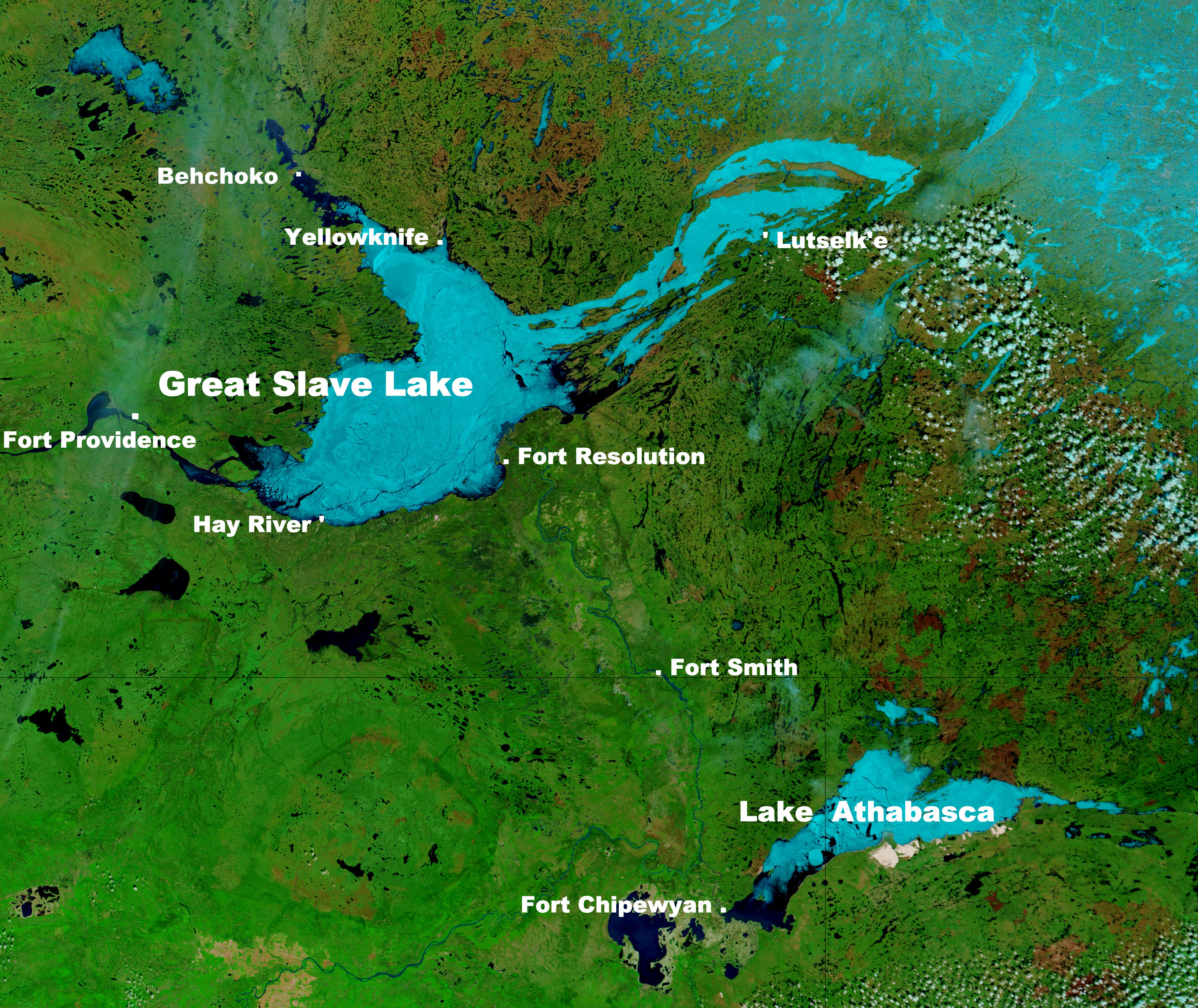
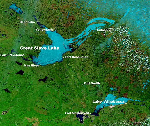
English: These true- and false-color images of central Canada show the Great Slave Lake in the Northwest Territories (top) and Lake Athabasca to the southeast. Lake Athabasca straddles the border between Alberta (west) and Saskatchewan (east). A fire (red dot) is burning in Alberta, and the snow capped Rocky Mountains cut through southwest Alberta at bottom left. In the false-color image, vegetation is green, water is dark blue, and ice (or snow) is light blue.
(Captions added by Kayoty) |
| ದಿನಾಂಕ | |
| ಆಕರ | Nasa (Visible Earth) |
| ಕರ್ತೃ | Jacques Descloitres, MODIS Land Rapid Response Team, NASA/GSFC |
ಪರವಾನಗಿ
| This file is in the public domain in the United States because it was solely created by NASA. NASA copyright policy states that "NASA material is not protected by copyright unless noted". (See Template:PD-USGov, NASA copyright policy page or JPL Image Use Policy.) | ||
 |
Warnings:
|
ಕಡತದ ಇತಿಹಾಸ
ದಿನ/ಕಾಲ ಒತ್ತಿದರೆ ಆ ಸಮಯದಲ್ಲಿ ಈ ಕಡತದ ವಸ್ತುಸ್ಥಿತಿ ತೋರುತ್ತದೆ.
| ದಿನ/ಕಾಲ | ಕಿರುನೋಟ | ಆಯಾಮಗಳು | ಬಳಕೆದಾರ | ಟಿಪ್ಪಣಿ | |
|---|---|---|---|---|---|
| ಪ್ರಸಕ್ತ | ೧೫:೪೭, ೧೬ ಸೆಪ್ಟೆಂಬರ್ ೨೦೧೪ | | ೨,೯೧೪ × ೨,೪೫೪ (೧.೮೨ MB) | Kayoty | added Behchoko to map |
| ೧೫:೦೩, ೧೬ ಸೆಪ್ಟೆಂಬರ್ ೨೦೧೪ |  | ೨,೯೧೪ × ೨,೪೫೪ (೧.೮೨ MB) | Kayoty | User created page with UploadWizard |
ಕಡತ ಬಳಕೆ
ಈ ಕೆಳಗಿನ ಪುಟವು ಈ ಚಿತ್ರಕ್ಕೆ ಸಂಪರ್ಕ ಹೊಂದಿದೆ:
ಜಾಗತಿಕ ಕಡತ ಉಪಯೋಗ
ಈ ಕಡತವನ್ನು ಕೆಳಗಿನ ಬೇರೆ ವಿಕಿಗಳೂ ಉಪಯೋಗಿಸುತ್ತಿವೆ:
- af.wikipedia.org ಮೇಲೆ ಬಳಕೆ
- bs.wikipedia.org ಮೇಲೆ ಬಳಕೆ
- en.wikipedia.org ಮೇಲೆ ಬಳಕೆ
- fa.wikipedia.org ಮೇಲೆ ಬಳಕೆ
- fr.wikipedia.org ಮೇಲೆ ಬಳಕೆ
- he.wikipedia.org ಮೇಲೆ ಬಳಕೆ
- id.wikipedia.org ಮೇಲೆ ಬಳಕೆ
- is.wikipedia.org ಮೇಲೆ ಬಳಕೆ
- la.wikipedia.org ಮೇಲೆ ಬಳಕೆ
- lv.wikipedia.org ಮೇಲೆ ಬಳಕೆ
- ml.wikipedia.org ಮೇಲೆ ಬಳಕೆ
- sl.wikipedia.org ಮೇಲೆ ಬಳಕೆ
- th.wikipedia.org ಮೇಲೆ ಬಳಕೆ
- vi.wikipedia.org ಮೇಲೆ ಬಳಕೆ
- vls.wikipedia.org ಮೇಲೆ ಬಳಕೆ
- xmf.wikipedia.org ಮೇಲೆ ಬಳಕೆ
- zh.wikipedia.org ಮೇಲೆ ಬಳಕೆ