
ಚಿತ್ರ:Cambridgeshire UK location map.svg

Size of this PNG preview of this SVG file: ೫೩೩ × ೬೦೦ ಪಿಕ್ಸೆಲ್ಗಳು. ಇತರ ರೆಸಲ್ಯೂಶನ್ಗಳು: ೨೧೩ × ೨೪೦ ಪಿಕ್ಸೆಲ್ಗಳು | ೪೨೬ × ೪೮೦ ಪಿಕ್ಸೆಲ್ಗಳು | ೬೮೨ × ೭೬೮ ಪಿಕ್ಸೆಲ್ಗಳು | ೯೧೦ × ೧,೦೨೪ ಪಿಕ್ಸೆಲ್ಗಳು | ೧,೮೨೦ × ೨,೦೪೮ ಪಿಕ್ಸೆಲ್ಗಳು | ೧,೧೨೫ × ೧,೨೬೬ ಪಿಕ್ಸೆಲ್ಗಳು.
ಮೂಲ ಕಡತ (SVG ಫೈಲು, ಸುಮಾರಾಗಿ ೧,೧೨೫ × ೧,೨೬೬ ಚಿತ್ರಬಿಂದುಗಳು, ಫೈಲಿನ ಗಾತ್ರ: ೧.೭೯ MB)
ಈ ಫೈಲು ವಿಕಿಮೀಡಿಯ ಕಾಮನ್ಸ್ನಲ್ಲಿ ಇರುವುದು. ಅಲ್ಲಿನ ವಿವರಣೆ ಪುಟವನ್ನೇ ಕೆಳಗೆ ತೋರಿಸಲಾಗಿದೆ. ಕಾಮನ್ಸ್ ಕೃತಿಸ್ವಾಮ್ಯತೆಯಿಂದ ಮುಕ್ತ ಫೈಲುಗಳ ಒಂದು ಆಗರ. ಅಲ್ಲಿ ನೀವೂ ಸಹಕರಿಸಬಹುದು. |
| ವಿವರ |
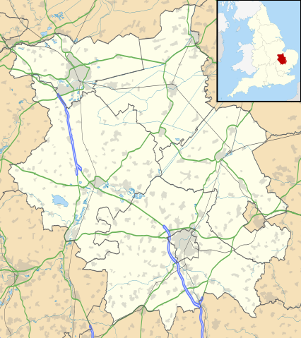
Map of Cambridgeshire, UK with the following information shown:
Equirectangular map projection on WGS 84 datum, with N/S stretched 160% Geographic limits:
|
| ದಿನಾಂಕ | |
| ಆಕರ |
|
| ಕರ್ತೃ | Nilfanion, created using Ordnance Survey data |
| ಅನುಮತಿ (ಈ ಕಡತವನ್ನು ಮರುಬಳಕೆ ಮಾಡಲಾಗುತ್ತಿದೆ) |
ಈ ಕಡತ ಕ್ರಿಯೇಟಿವ್ ಕಾಮನ್ಸ್ Attribution
-Share Alike 3.0 Unported ಪರವಾನಗಿ ಹೊಂದಿದೆ. ವೈಶಿಷ್ಟ್ಯ: Contains Ordnance Survey data © Crown copyright and database right
|
| ಇತರೆ ಆವೃತ್ತಿಗಳು | File:Cambridgeshire UK district map (blank).svg - Blank map |
.svg)
ಕಡತದ ಇತಿಹಾಸ
ದಿನ/ಕಾಲ ಒತ್ತಿದರೆ ಆ ಸಮಯದಲ್ಲಿ ಈ ಕಡತದ ವಸ್ತುಸ್ಥಿತಿ ತೋರುತ್ತದೆ.
| ದಿನ/ಕಾಲ | ಕಿರುನೋಟ | ಆಯಾಮಗಳು | ಬಳಕೆದಾರ | ಟಿಪ್ಪಣಿ | |
|---|---|---|---|---|---|
| ಪ್ರಸಕ್ತ | ೦೦:೧೧, ೨೭ ಸೆಪ್ಟೆಂಬರ್ ೨೦೧೦ | | ೧,೧೨೫ × ೧,೨೬೬ (೧.೭೯ MB) | Nilfanion | {{Information |Description=Map of Cambridgeshire, UK with the following information shown: *Administrative borders *Coastline, lakes and rivers *Roads and railways *Urban areas Equirectangular map projection on WGS 84 datum, with N/S |
ಕಡತ ಬಳಕೆ
ಈ ಕೆಳಗಿನ ಪುಟವು ಈ ಚಿತ್ರಕ್ಕೆ ಸಂಪರ್ಕ ಹೊಂದಿದೆ:
ಜಾಗತಿಕ ಕಡತ ಉಪಯೋಗ
ಈ ಕಡತವನ್ನು ಕೆಳಗಿನ ಬೇರೆ ವಿಕಿಗಳೂ ಉಪಯೋಗಿಸುತ್ತಿವೆ:
- ar.wikipedia.org ಮೇಲೆ ಬಳಕೆ
- bg.wikipedia.org ಮೇಲೆ ಬಳಕೆ
- ceb.wikipedia.org ಮೇಲೆ ಬಳಕೆ
- en.wikipedia.org ಮೇಲೆ ಬಳಕೆ
- Peterborough
- Kimbolton Castle
- St Ives, Cambridgeshire
- Littleport
- Ramsey Abbey
- St Neots
- Eye, Cambridgeshire
- Eye Green
- Werrington, Peterborough
- Grantchester
- Wisbech
- Coton, Cambridgeshire
- Flag Fen
- Burwell, Cambridgeshire
- Huntingdon
- Perry, Cambridgeshire
- Gamlingay
- Godmanchester
- Eynesbury, Cambridgeshire
- Eaton Ford
- Eaton Socon
- Kimbolton, Cambridgeshire
- Chesterton, Cambridge
- Cambourne
- Soham
- Duxford
- Ramsey, Cambridgeshire
- Orton, Peterborough
- Whittlesey
- March, Cambridgeshire
- Girton College, Cambridge
- Chatteris
- Caldecote, South Cambridgeshire
- Addenbrooke's Hospital
- The Abingtons, Cambridgeshire
- Meldreth
- Denny Abbey
- Wimpole Estate
- Anglesey Abbey
- Hampton, Peterborough
- Thorpe Hall (Peterborough)
- Isleham
- Witcham
- Fulbourn
- Great Wilbraham
- Little Wilbraham
ಈ ಫೈಲ್ನ ಹೆಚ್ಚು ಜಾಗತಿಕ ಬಳಕೆಯನ್ನು ವೀಕ್ಷಿಸಿ.