
ಚಿತ್ರ:Australian Capital Territory parishes.png
ಈ ಮುನ್ನೋಟ ಗಾತ್ರ:೩೯೬ × ೫೯೯ ಪಿಕ್ಸೆಲ್ಗಳು. ಇತರ ರೆಸಲ್ಯೂಶನ್ಗಳು: ೧೫೮ × ೨೪೦ ಪಿಕ್ಸೆಲ್ಗಳು | ೬೦೦ × ೯೦೮ ಪಿಕ್ಸೆಲ್ಗಳು.
ಮೂಲ ಕಡತ (೬೦೦ × ೯೦೮ ಚಿತ್ರಬಿಂದು, ಫೈಲಿನ ಗಾತ್ರ: ೫೪ KB, MIME ಪ್ರಕಾರ: image/png)
ಈ ಫೈಲು ವಿಕಿಮೀಡಿಯ ಕಾಮನ್ಸ್ನಲ್ಲಿ ಇರುವುದು. ಅಲ್ಲಿನ ವಿವರಣೆ ಪುಟವನ್ನೇ ಕೆಳಗೆ ತೋರಿಸಲಾಗಿದೆ. ಕಾಮನ್ಸ್ ಕೃತಿಸ್ವಾಮ್ಯತೆಯಿಂದ ಮುಕ್ತ ಫೈಲುಗಳ ಒಂದು ಆಗರ. ಅಲ್ಲಿ ನೀವೂ ಸಹಕರಿಸಬಹುದು. |
ಸಾರಾಂಶ
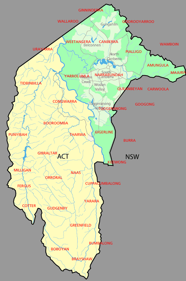
| ವಿವರ | Parishes (shown in red) in the area of the Australian Capital Territory. The ones wholly within the ACT are former parishes and do not exist anymore. The land in green was part of Murray County, that in yellow part of Cowley County. (Divided by the Murrumbidgee River) |
| ದಿನಾಂಕ | |
| ಆಕರ | Made from Martyman's GFDL map of the ACT here, using information from the National Library of Australia map here (Map showing proposed Federal Capital Territory and tenures of land within same, 1909) |
| ಕರ್ತೃ | derivative of Martyman's GFDL map |
ಪರವಾನಗಿ

|
GNU ಉಚಿತ ಡಾಕ್ಯುಮೆಂಟೇಶನ್ ಪರವಾನಗಿ, ಆವೃತ್ತಿಯ ನಿಯಮಗಳ ಅಡಿಯಲ್ಲಿ ಈ ಡಾಕ್ಯುಮೆಂಟ್ ಅನ್ನು ನಕಲಿಸಲು, ವಿತರಿಸಲು ಮತ್ತು/ಅಥವಾ ಮಾರ್ಪಡಿಸಲು ಅನುಮತಿಯನ್ನು ನೀಡಲಾಗಿದೆ. 1.2 ಅಥವಾ ಯಾವುದೇ ನಂತರದ ಆವೃತ್ತಿಯನ್ನು ಉಚಿತ ಸಾಫ್ಟ್ವೇರ್ ಫೌಂಡೇಶನ್ ಪ್ರಕಟಿಸಿದೆ; ಯಾವುದೇ ಅಸ್ಥಿರ ವಿಭಾಗಗಳಿಲ್ಲದೆ, ಮುಖ ಪಠ್ಯಗಳಿಲ್ಲ ಮತ್ತು ಹಿಂದಿನ ಕವರ್ ಪಠ್ಯಗಳಿಲ್ಲ. ಪರವಾನಗಿಯ ಪ್ರತಿಯನ್ನು GNU ಉಚಿತ ಡಾಕ್ಯುಮೆಂಟೇಶನ್ ಪರವಾನಗಿ ಎಂಬ ವಿಭಾಗದಲ್ಲಿ ಸೇರಿಸಲಾಗಿದೆ. |
| ಈ ಕಡತ ಕ್ರಿಯೇಟಿವ್ ಕಾಮನ್ಸ್ Attribution -Share Alike 3.0 Unported ಪರವಾನಗಿ ಹೊಂದಿದೆ. | ||
| ||
| This licensing tag was added to this file as part of the GFDL licensing update. |
ಕಡತದ ಇತಿಹಾಸ
ದಿನ/ಕಾಲ ಒತ್ತಿದರೆ ಆ ಸಮಯದಲ್ಲಿ ಈ ಕಡತದ ವಸ್ತುಸ್ಥಿತಿ ತೋರುತ್ತದೆ.
| ದಿನ/ಕಾಲ | ಕಿರುನೋಟ | ಆಯಾಮಗಳು | ಬಳಕೆದಾರ | ಟಿಪ್ಪಣಿ | |
|---|---|---|---|---|---|
| ಪ್ರಸಕ್ತ | ೦೫:೫೯, ೨೫ ಆಗಸ್ಟ್ ೨೦೦೭ | | ೬೦೦ × ೯೦೮ (೫೪ KB) | Roke~commonswiki | add a few more |
| ೧೫:೦೬, ೨೩ ಏಪ್ರಿಲ್ ೨೦೦೭ |  | ೬೦೦ × ೯೦೮ (೧೫೦ KB) | Roke~commonswiki | {{Information |Description=Parishes (shown in red) in the area of the Australian Capital Territory. The ones wholly within the ACT are former parishes and do not exist anymore. The land in green was part of [[w:Murray Co |
ಕಡತ ಬಳಕೆ
ಈ ಕೆಳಗಿನ 2 ಪುಟಗಳು ಈ ಚಿತ್ರಕ್ಕೆ ಸಂಪರ್ಕ ಹೊಂದಿವೆ:
ಜಾಗತಿಕ ಕಡತ ಉಪಯೋಗ
ಈ ಕಡತವನ್ನು ಕೆಳಗಿನ ಬೇರೆ ವಿಕಿಗಳೂ ಉಪಯೋಗಿಸುತ್ತಿವೆ:
- en.wikipedia.org ಮೇಲೆ ಬಳಕೆ
- es.wikipedia.org ಮೇಲೆ ಬಳಕೆ
- fr.wikipedia.org ಮೇಲೆ ಬಳಕೆ
- hi.wikipedia.org ಮೇಲೆ ಬಳಕೆ
- hu.wikipedia.org ಮೇಲೆ ಬಳಕೆ
- ja.wikipedia.org ಮೇಲೆ ಬಳಕೆ
- ml.wikipedia.org ಮೇಲೆ ಬಳಕೆ
- ms.wikipedia.org ಮೇಲೆ ಬಳಕೆ
- pt.wikipedia.org ಮೇಲೆ ಬಳಕೆ
- ru.wikipedia.org ಮೇಲೆ ಬಳಕೆ
- sd.wikipedia.org ಮೇಲೆ ಬಳಕೆ
- simple.wikipedia.org ಮೇಲೆ ಬಳಕೆ
- si.wikipedia.org ಮೇಲೆ ಬಳಕೆ
- to.wikipedia.org ಮೇಲೆ ಬಳಕೆ
- uz.wikipedia.org ಮೇಲೆ ಬಳಕೆ