
ಚಿತ್ರ:Australia Victoria Southern Grampians Shire location map.svg

Size of this PNG preview of this SVG file: ೫೩೩ × ೪೯೧ ಪಿಕ್ಸೆಲ್ಗಳು. ಇತರ ರೆಸಲ್ಯೂಶನ್ಗಳು: ೨೬೧ × ೨೪೦ ಪಿಕ್ಸೆಲ್ಗಳು | ೫೨೧ × ೪೮೦ ಪಿಕ್ಸೆಲ್ಗಳು | ೮೩೪ × ೭೬೮ ಪಿಕ್ಸೆಲ್ಗಳು | ೧,೧೧೨ × ೧,೦೨೪ ಪಿಕ್ಸೆಲ್ಗಳು | ೨,೨೨೩ × ೨,೦೪೮ ಪಿಕ್ಸೆಲ್ಗಳು.
ಮೂಲ ಕಡತ (SVG ಫೈಲು, ಸುಮಾರಾಗಿ ೫೩೩ × ೪೯೧ ಚಿತ್ರಬಿಂದುಗಳು, ಫೈಲಿನ ಗಾತ್ರ: ೬೪೦ KB)
ಈ ಫೈಲು ವಿಕಿಮೀಡಿಯ ಕಾಮನ್ಸ್ನಲ್ಲಿ ಇರುವುದು. ಅಲ್ಲಿನ ವಿವರಣೆ ಪುಟವನ್ನೇ ಕೆಳಗೆ ತೋರಿಸಲಾಗಿದೆ. ಕಾಮನ್ಸ್ ಕೃತಿಸ್ವಾಮ್ಯತೆಯಿಂದ ಮುಕ್ತ ಫೈಲುಗಳ ಒಂದು ಆಗರ. ಅಲ್ಲಿ ನೀವೂ ಸಹಕರಿಸಬಹುದು. |
| ವಿವರ |
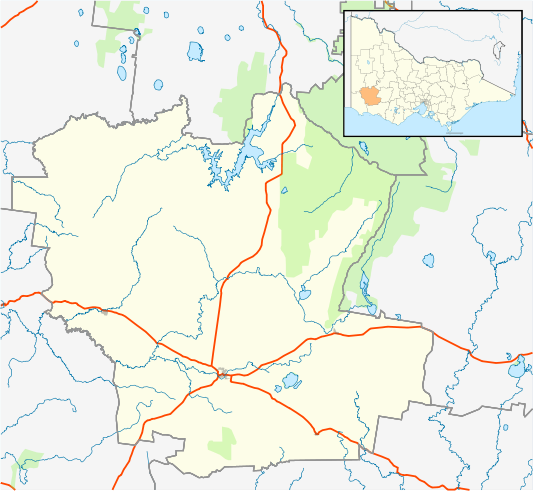
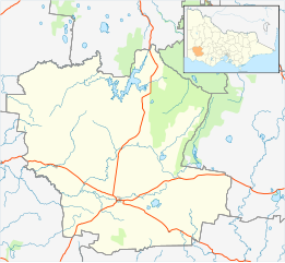
English: Blank map of w:Southern Grampians Shire, Victoria, Australia, with the following information shown:
Geographic limits:
|
||
| ಆಕರ | ಸ್ವಂತ ಕೆಲಸ + VicMap Lite | ||
| ಕರ್ತೃ | Cassowary |

ಕಡತದ ಇತಿಹಾಸ
ದಿನ/ಕಾಲ ಒತ್ತಿದರೆ ಆ ಸಮಯದಲ್ಲಿ ಈ ಕಡತದ ವಸ್ತುಸ್ಥಿತಿ ತೋರುತ್ತದೆ.
| ದಿನ/ಕಾಲ | ಕಿರುನೋಟ | ಆಯಾಮಗಳು | ಬಳಕೆದಾರ | ಟಿಪ್ಪಣಿ | |
|---|---|---|---|---|---|
| ಪ್ರಸಕ್ತ | ೨೧:೩೦, ೧೮ ಫೆಬ್ರವರಿ ೨೦೧೧ | | ೫೩೩ × ೪೯೧ (೬೪೦ KB) | Cassowary | {{Information |Description ={{en|1=Blank map of w:Southern Grampians Shire, Victoria, Australia, with the following information shown: * LGA boundaries * Coastline, lakes and rivers * Highways and freeways * Urban areas * Parks Geographic limits: |
ಕಡತ ಬಳಕೆ
ಈ ಕೆಳಗಿನ ಪುಟವು ಈ ಚಿತ್ರಕ್ಕೆ ಸಂಪರ್ಕ ಹೊಂದಿದೆ:
ಜಾಗತಿಕ ಕಡತ ಉಪಯೋಗ
ಈ ಕಡತವನ್ನು ಕೆಳಗಿನ ಬೇರೆ ವಿಕಿಗಳೂ ಉಪಯೋಗಿಸುತ್ತಿವೆ:
- ar.wikipedia.org ಮೇಲೆ ಬಳಕೆ
- ceb.wikipedia.org ಮೇಲೆ ಬಳಕೆ
- en.wikipedia.org ಮೇಲೆ ಬಳಕೆ
- Shire of Southern Grampians
- Hamilton, Victoria
- Coleraine, Victoria
- Penshurst, Victoria
- Dunkeld, Victoria
- Glenthompson, Victoria
- Template:Towns in Southern Grampians Shire
- Tabor, Victoria
- Tarrington, Victoria
- Balmoral, Victoria
- Branxholme, Victoria
- Byaduk
- Cavendish, Victoria
- Module:Location map/data/Australia Victoria Shire of Southern Grampians/doc
- Pigeon Ponds
- Konongwootong
- Tahara, Victoria
- Module:Location map/data/Australia Victoria Shire of Southern Grampians
- User:Viatori/sandbox
- User:ThylacineHunter/LGA
- Brit Brit, Victoria
- Bochara, Victoria
- Gringegalgona, Victoria
- fa.wikipedia.org ಮೇಲೆ ಬಳಕೆ
- si.wikipedia.org ಮೇಲೆ ಬಳಕೆ
- tr.wikipedia.org ಮೇಲೆ ಬಳಕೆ
- uz.wikipedia.org ಮೇಲೆ ಬಳಕೆ
- war.wikipedia.org ಮೇಲೆ ಬಳಕೆ