
ಚಿತ್ರ:1870 Index Chart to GTS India-1.jpg
ಈ ಮುನ್ನೋಟ ಗಾತ್ರ:೬೨೫ × ೫೯೯ ಪಿಕ್ಸೆಲ್ಗಳು. ಇತರ ರೆಸಲ್ಯೂಶನ್ಗಳು: ೨೫೦ × ೨೪೦ ಪಿಕ್ಸೆಲ್ಗಳು | ೫೦೧ × ೪೮೦ ಪಿಕ್ಸೆಲ್ಗಳು | ೮೦೧ × ೭೬೮ ಪಿಕ್ಸೆಲ್ಗಳು | ೧,೦೬೮ × ೧,೦೨೪ ಪಿಕ್ಸೆಲ್ಗಳು | ೨,೧೩೬ × ೨,೦೪೮ ಪಿಕ್ಸೆಲ್ಗಳು | ೭,೩೦೮ × ೭,೦೦೬ ಪಿಕ್ಸೆಲ್ಗಳು.
ಮೂಲ ಕಡತ (೭,೩೦೮ × ೭,೦೦೬ ಚಿತ್ರಬಿಂದು, ಫೈಲಿನ ಗಾತ್ರ: ೨೫.೫೫ MB, MIME ಪ್ರಕಾರ: image/jpeg)
ಈ ಫೈಲು ವಿಕಿಮೀಡಿಯ ಕಾಮನ್ಸ್ನಲ್ಲಿ ಇರುವುದು. ಅಲ್ಲಿನ ವಿವರಣೆ ಪುಟವನ್ನೇ ಕೆಳಗೆ ತೋರಿಸಲಾಗಿದೆ. ಕಾಮನ್ಸ್ ಕೃತಿಸ್ವಾಮ್ಯತೆಯಿಂದ ಮುಕ್ತ ಫೈಲುಗಳ ಒಂದು ಆಗರ. ಅಲ್ಲಿ ನೀವೂ ಸಹಕರಿಸಬಹುದು. |
ಸಾರಾಂಶ
ಪರವಾನಗಿ
This media file is in the public domain in the United States. This applies to U.S. works where the copyright has expired, often because its first publication occurred prior to January 1, 1929, and if not then due to lack of notice or renewal. See this page for further explanation.
|
 | |
 |
This image might not be in the public domain outside of the United States; this especially applies in the countries and areas that do not apply the rule of the shorter term for US works, such as Canada, Mainland China (not Hong Kong or Macao), Germany, Mexico, and Switzerland. The creator and year of publication are essential information and must be provided. See Wikipedia:Public domain and Wikipedia:Copyrights for more details.
|
ಕಡತದ ಇತಿಹಾಸ
ದಿನ/ಕಾಲ ಒತ್ತಿದರೆ ಆ ಸಮಯದಲ್ಲಿ ಈ ಕಡತದ ವಸ್ತುಸ್ಥಿತಿ ತೋರುತ್ತದೆ.
| ದಿನ/ಕಾಲ | ಕಿರುನೋಟ | ಆಯಾಮಗಳು | ಬಳಕೆದಾರ | ಟಿಪ್ಪಣಿ | |
|---|---|---|---|---|---|
| ಪ್ರಸಕ್ತ | ೧೮:೦೭, ೬ ಆಗಸ್ಟ್ ೨೦೧೪ | | ೭,೩೦೮ × ೭,೦೦೬ (೨೫.೫೫ MB) | Shyamal | clean |
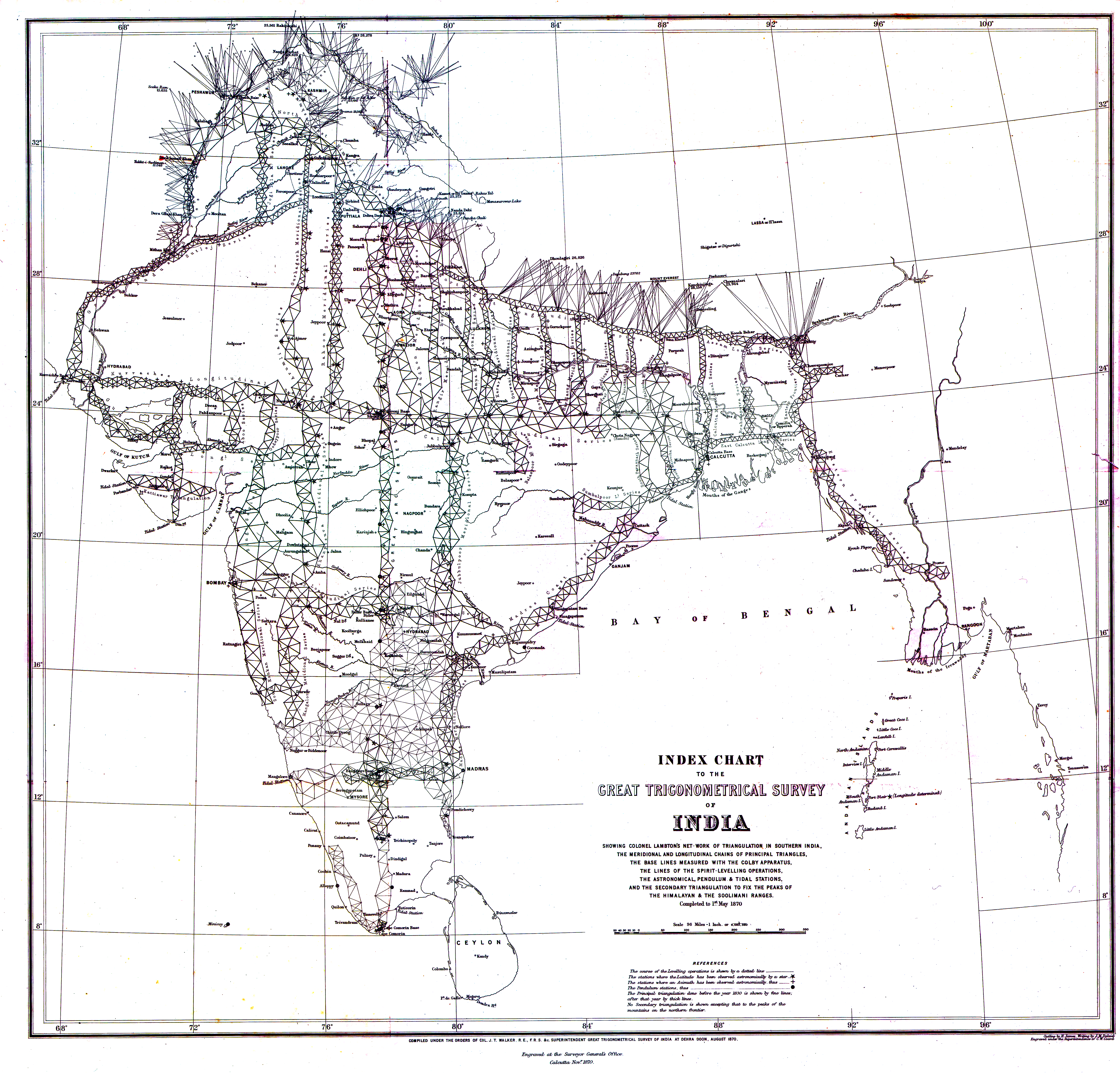
| ೦೫:೫೨, ೫ ಸೆಪ್ಟೆಂಬರ್ ೨೦೧೩ |  | ೭,೩೦೮ × ೭,೦೦೬ (೩.೫೨ MB) | SanderO | {{Information |Description ={{en|1=1870 Index Chart of the Great Trigonometric Survey of India}} {{nl|1=1870 kaart van de Grote Trigonometrische Kartering van India}} |Source =Survey of India |Author =Survey of India |Date ... |
ಕಡತ ಬಳಕೆ
ಈ ಕೆಳಗಿನ ಪುಟವು ಈ ಚಿತ್ರಕ್ಕೆ ಸಂಪರ್ಕ ಹೊಂದಿದೆ:
ಜಾಗತಿಕ ಕಡತ ಉಪಯೋಗ
ಈ ಕಡತವನ್ನು ಕೆಳಗಿನ ಬೇರೆ ವಿಕಿಗಳೂ ಉಪಯೋಗಿಸುತ್ತಿವೆ:
- bg.wikipedia.org ಮೇಲೆ ಬಳಕೆ
- ca.wikipedia.org ಮೇಲೆ ಬಳಕೆ
- da.wikipedia.org ಮೇಲೆ ಬಳಕೆ
- de.wikipedia.org ಮೇಲೆ ಬಳಕೆ
- el.wikipedia.org ಮೇಲೆ ಬಳಕೆ
- en.wikipedia.org ಮೇಲೆ ಬಳಕೆ
- es.wikipedia.org ಮೇಲೆ ಬಳಕೆ
- eu.wikipedia.org ಮೇಲೆ ಬಳಕೆ
- hi.wikipedia.org ಮೇಲೆ ಬಳಕೆ
- id.wikipedia.org ಮೇಲೆ ಬಳಕೆ
- it.wikipedia.org ಮೇಲೆ ಬಳಕೆ
- ja.wikipedia.org ಮೇಲೆ ಬಳಕೆ
- la.wikipedia.org ಮೇಲೆ ಬಳಕೆ
- mk.wikipedia.org ಮೇಲೆ ಬಳಕೆ
- mt.wikipedia.org ಮೇಲೆ ಬಳಕೆ
- nl.wikipedia.org ಮೇಲೆ ಬಳಕೆ
- pt.wikipedia.org ಮೇಲೆ ಬಳಕೆ
- ro.wikipedia.org ಮೇಲೆ ಬಳಕೆ
- ru.wikipedia.org ಮೇಲೆ ಬಳಕೆ
- sr.wikipedia.org ಮೇಲೆ ಬಳಕೆ
- te.wikipedia.org ಮೇಲೆ ಬಳಕೆ
- uk.wikipedia.org ಮೇಲೆ ಬಳಕೆ
- www.wikidata.org ಮೇಲೆ ಬಳಕೆ
- zh.wikipedia.org ಮೇಲೆ ಬಳಕೆ