
ಚಿತ್ರ:Portugal topographic map-pt.png
ಈ ಮುನ್ನೋಟ ಗಾತ್ರ:೩೩೯ × ೫೯೯ ಪಿಕ್ಸೆಲ್ಗಳು. ಇತರ ರೆಸಲ್ಯೂಶನ್ಗಳು: ೧೩೬ × ೨೪೦ ಪಿಕ್ಸೆಲ್ಗಳು | ೨೭೨ × ೪೮೦ ಪಿಕ್ಸೆಲ್ಗಳು | ೪೩೫ × ೭೬೮ ಪಿಕ್ಸೆಲ್ಗಳು | ೫೭೯ × ೧,೦೨೪ ಪಿಕ್ಸೆಲ್ಗಳು | ೧,೭೩೮ × ೩,೦೭೦ ಪಿಕ್ಸೆಲ್ಗಳು.
ಮೂಲ ಕಡತ (೧,೭೩೮ × ೩,೦೭೦ ಚಿತ್ರಬಿಂದು, ಫೈಲಿನ ಗಾತ್ರ: ೪.೬ MB, MIME ಪ್ರಕಾರ: image/png)
ಈ ಫೈಲು ವಿಕಿಮೀಡಿಯ ಕಾಮನ್ಸ್ನಲ್ಲಿ ಇರುವುದು. ಅಲ್ಲಿನ ವಿವರಣೆ ಪುಟವನ್ನೇ ಕೆಳಗೆ ತೋರಿಸಲಾಗಿದೆ. ಕಾಮನ್ಸ್ ಕೃತಿಸ್ವಾಮ್ಯತೆಯಿಂದ ಮುಕ್ತ ಫೈಲುಗಳ ಒಂದು ಆಗರ. ಅಲ್ಲಿ ನೀವೂ ಸಹಕರಿಸಬಹುದು. |
| ವಿವರ |
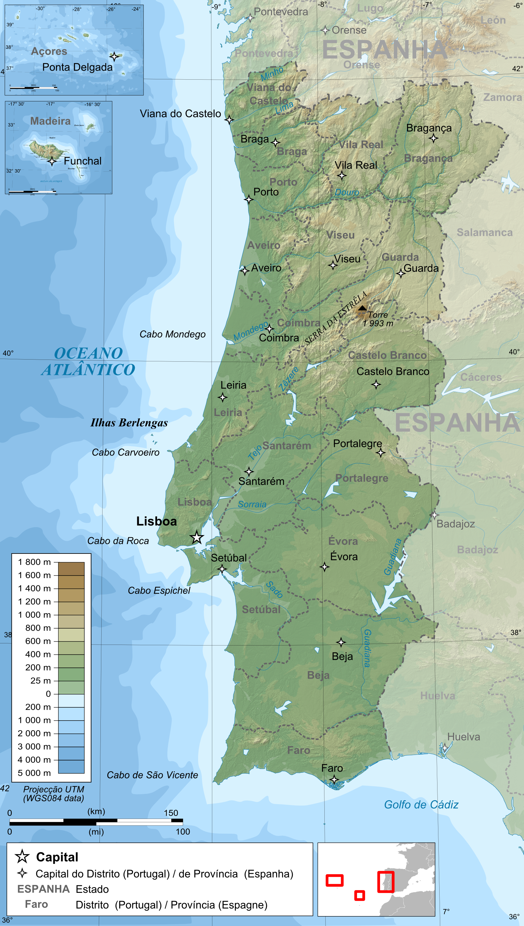
Français : Carte topographique et administrative en portugais du Portugal
Português: Carta topográfica e da administração do Portugal, em português
Deutsch: Topographische Karte von Portugal, portugiesische Version English: Topographic and administrative map in Portuguese of Portugal Español: Mapa topográfico y administrativo en portugés del Portugal Italiano: Carta topografica e amministrativa de Portogallo 日本語: ポルトガル語で表示したポルトガル地形·行政地図 |
||
| ದಿನಾಂಕ | |||
| ಆಕರ |
English: Own work ;
Français : Création personnelle ;
|
||
| ಕರ್ತೃ | Bourrichon - fr:Bourrichon | ||
| ಅನುಮತಿ (ಈ ಕಡತವನ್ನು ಮರುಬಳಕೆ ಮಾಡಲಾಗುತ್ತಿದೆ) |
I, the copyright holder of this work, hereby publish it under the following licenses:
This file is licensed under the Creative Commons Attribution-Share Alike 3.0 Unported, 2.5 Generic, 2.0 Generic and 1.0 Generic license.
ನಿಮ್ಮಿಚ್ಛೆಯ ಪರವಾನಗಿಯನ್ನು ನೀವು ಆರಿಸಿಕೊಳ್ಳಬಹುದು. |
||
| ಇತರೆ ಆವೃತ್ತಿಗಳು |
|


ಕಡತದ ಇತಿಹಾಸ
ದಿನ/ಕಾಲ ಒತ್ತಿದರೆ ಆ ಸಮಯದಲ್ಲಿ ಈ ಕಡತದ ವಸ್ತುಸ್ಥಿತಿ ತೋರುತ್ತದೆ.
| ದಿನ/ಕಾಲ | ಕಿರುನೋಟ | ಆಯಾಮಗಳು | ಬಳಕೆದಾರ | ಟಿಪ್ಪಣಿ | |
|---|---|---|---|---|---|
| ಪ್ರಸಕ್ತ | ೦೨:೨೧, ೧೫ ಜೂನ್ ೨೦೦೯ | | ೧,೭೩೮ × ೩,೦೭೦ (೪.೬ MB) | Bourrichon | {{Information |Description= {{fr|Carte topographique et administrative en portugais du Portugal}} {{pt|Carta topográfica e da administração do Portugal, em português}} {{de|Topographische Karte von [[:de:Portugal|Port |
ಕಡತ ಬಳಕೆ
ಈ ಕೆಳಗಿನ ಪುಟವು ಈ ಚಿತ್ರಕ್ಕೆ ಸಂಪರ್ಕ ಹೊಂದಿದೆ:
ಜಾಗತಿಕ ಕಡತ ಉಪಯೋಗ
ಈ ಕಡತವನ್ನು ಕೆಳಗಿನ ಬೇರೆ ವಿಕಿಗಳೂ ಉಪಯೋಗಿಸುತ್ತಿವೆ:
- bxr.wikipedia.org ಮೇಲೆ ಬಳಕೆ
- de.wikipedia.org ಮೇಲೆ ಬಳಕೆ
- el.wikipedia.org ಮೇಲೆ ಬಳಕೆ
- en.wikipedia.org ಮೇಲೆ ಬಳಕೆ
- en.wikiversity.org ಮೇಲೆ ಬಳಕೆ
- fr.wikipedia.org ಮೇಲೆ ಬಳಕೆ
- hr.wikipedia.org ಮೇಲೆ ಬಳಕೆ
- hr.wiktionary.org ಮೇಲೆ ಬಳಕೆ
- ilo.wikipedia.org ಮೇಲೆ ಬಳಕೆ
- ja.wikipedia.org ಮೇಲೆ ಬಳಕೆ
- ko.wikipedia.org ಮೇಲೆ ಬಳಕೆ
- la.wiktionary.org ಮೇಲೆ ಬಳಕೆ
- lez.wikipedia.org ಮೇಲೆ ಬಳಕೆ
- mn.wikipedia.org ಮೇಲೆ ಬಳಕೆ
- ps.wikipedia.org ಮೇಲೆ ಬಳಕೆ
- pt.wikipedia.org ಮೇಲೆ ಬಳಕೆ
- ro.wikipedia.org ಮೇಲೆ ಬಳಕೆ
- sd.wikipedia.org ಮೇಲೆ ಬಳಕೆ
- sl.wikipedia.org ಮೇಲೆ ಬಳಕೆ
- test2.wikipedia.org ಮೇಲೆ ಬಳಕೆ
- te.wikipedia.org ಮೇಲೆ ಬಳಕೆ
- th.wikipedia.org ಮೇಲೆ ಬಳಕೆ
- tr.wikipedia.org ಮೇಲೆ ಬಳಕೆ
- vi.wikipedia.org ಮೇಲೆ ಬಳಕೆ
- zh.wikipedia.org ಮೇಲೆ ಬಳಕೆ