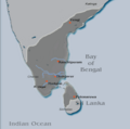
ಚಿತ್ರ:Pandya Kingdom (south India).png

ಈ ಮುನ್ನೋಟ ಗಾತ್ರ:೭೭೧ × ೬೦೦ ಪಿಕ್ಸೆಲ್ಗಳು. ಇತರ ರೆಸಲ್ಯೂಶನ್ಗಳು: ೩೦೯ × ೨೪೦ ಪಿಕ್ಸೆಲ್ಗಳು | ೬೧೭ × ೪೮೦ ಪಿಕ್ಸೆಲ್ಗಳು | ೯೮೭ × ೭೬೮ ಪಿಕ್ಸೆಲ್ಗಳು | ೧,೨೮೦ × ೯೯೬ ಪಿಕ್ಸೆಲ್ಗಳು | ೧,೭೨೦ × ೧,೩೩೮ ಪಿಕ್ಸೆಲ್ಗಳು.
ಮೂಲ ಕಡತ (೧,೭೨೦ × ೧,೩೩೮ ಚಿತ್ರಬಿಂದು, ಫೈಲಿನ ಗಾತ್ರ: ೪೪೩ KB, MIME ಪ್ರಕಾರ: image/png)
ಕಡತದ ಇತಿಹಾಸ
ದಿನ/ಕಾಲ ಒತ್ತಿದರೆ ಆ ಸಮಯದಲ್ಲಿ ಈ ಕಡತದ ವಸ್ತುಸ್ಥಿತಿ ತೋರುತ್ತದೆ.
| ದಿನ/ಕಾಲ | ಕಿರುನೋಟ | ಆಯಾಮಗಳು | ಬಳಕೆದಾರ | ಟಿಪ್ಪಣಿ | |
|---|---|---|---|---|---|
| ಪ್ರಸಕ್ತ | ೧೬:೦೬, ೨೮ ಜನವರಿ ೨೦೨೧ |  | ೧,೭೨೦ × ೧,೩೩೮ (೪೪೩ KB) | Ouṃkāra | Reverted to version as of 14:28, 20 March 2020 (UTC) |
| ೧೮:೪೨, ೨೯ ಜುಲೈ ೨೦೨೦ |  | ೪೩೦ × ೪೨೭ (೨೩ KB) | Panda619 | Reverted to version as of 23:37, 13 December 2006 (UTC) unsourced | |
| ೧೯:೫೮, ೨೦ ಮಾರ್ಚ್ ೨೦೨೦ |  | ೧,೭೨೦ × ೧,೩೩೮ (೪೪೩ KB) | StephenPaa | Corrected borders | |
| ೧೪:೪೬, ೨೬ ನವೆಂಬರ್ ೨೦೧೯ |  | ೧,೯೬೨ × ೧,೩೩೮ (೪೫೯ KB) | StephenPaa | Added rivers | |
| ೨೨:೩೯, ೨೫ ನವೆಂಬರ್ ೨೦೧೯ |  | ೧,೯೬೬ × ೧,೪೨೦ (೮.೦೧ MB) | StephenPaa | Corrected maximam extent | |
| ೦೫:೦೭, ೧೪ ಡಿಸೆಂಬರ್ ೨೦೦೬ |  | ೪೩೦ × ೪೨೭ (೨೩ KB) | Electionworld | {{ew|en|Venu62}} Extent of Pandya Territories under Jatavarman Sundara Pandya (1251 - 1283 C.E.) == Licensing == {{GFDL-user|Venu62}} |
ಕಡತ ಬಳಕೆ
ಈ ಕೆಳಗಿನ 2 ಪುಟಗಳು ಈ ಚಿತ್ರಕ್ಕೆ ಸಂಪರ್ಕ ಹೊಂದಿವೆ:
ಜಾಗತಿಕ ಕಡತ ಉಪಯೋಗ
ಈ ಕಡತವನ್ನು ಕೆಳಗಿನ ಬೇರೆ ವಿಕಿಗಳೂ ಉಪಯೋಗಿಸುತ್ತಿವೆ:
- ar.wikipedia.org ಮೇಲೆ ಬಳಕೆ
- ba.wikipedia.org ಮೇಲೆ ಬಳಕೆ
- bn.wikipedia.org ಮೇಲೆ ಬಳಕೆ
- ca.wikipedia.org ಮೇಲೆ ಬಳಕೆ
- de.wikipedia.org ಮೇಲೆ ಬಳಕೆ
- en.wikipedia.org ಮೇಲೆ ಬಳಕೆ
- Jatavarman Sundara Pandyan I
- Jaffna kingdom
- Aryacakravarti dynasty
- Talk:Pandyan kingdom/Pandyas rewrite
- History of Tamil Nadu
- History of Mangalore
- User:Sundar2000
- User talk:Jayantanth/Archive 1
- User:ShivNarayanan
- History of Madurai
- History of the Jaffna Kingdom
- User:Wiki Raja/Gallery
- List of Hindu empires and dynasties
- fr.wikipedia.org ಮೇಲೆ ಬಳಕೆ
- gu.wikipedia.org ಮೇಲೆ ಬಳಕೆ
- hi.wikipedia.org ಮೇಲೆ ಬಳಕೆ
- hu.wikipedia.org ಮೇಲೆ ಬಳಕೆ
- hy.wikipedia.org ಮೇಲೆ ಬಳಕೆ
- id.wikipedia.org ಮೇಲೆ ಬಳಕೆ
- ja.wikipedia.org ಮೇಲೆ ಬಳಕೆ
- ko.wikipedia.org ಮೇಲೆ ಬಳಕೆ
- lt.wikipedia.org ಮೇಲೆ ಬಳಕೆ
- ml.wikipedia.org ಮೇಲೆ ಬಳಕೆ
- mr.wikipedia.org ಮೇಲೆ ಬಳಕೆ
- nl.wikipedia.org ಮೇಲೆ ಬಳಕೆ
- nn.wikipedia.org ಮೇಲೆ ಬಳಕೆ
- no.wikipedia.org ಮೇಲೆ ಬಳಕೆ
- pa.wikipedia.org ಮೇಲೆ ಬಳಕೆ
- pl.wikipedia.org ಮೇಲೆ ಬಳಕೆ
- pnb.wikipedia.org ಮೇಲೆ ಬಳಕೆ
- pt.wikipedia.org ಮೇಲೆ ಬಳಕೆ
- ru.wikipedia.org ಮೇಲೆ ಬಳಕೆ
ಈ ಫೈಲ್ನ ಹೆಚ್ಚು ಜಾಗತಿಕ ಬಳಕೆಯನ್ನು ವೀಕ್ಷಿಸಿ.


