ಚಿತ್ರ:Mauryan Empire Map.gif
Mauryan_Empire_Map.gif (೪೦೦ × ೩೩೭ ಚಿತ್ರಬಿಂದು, ಫೈಲಿನ ಗಾತ್ರ: ೧೧ KB, MIME ಪ್ರಕಾರ: image/gif)
Summary[ಬದಲಾಯಿಸಿ]
Description[ಬದಲಾಯಿಸಿ]
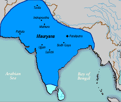
A poltical map of the Mauryan Empire, including notable cities, such as the capital Pataliputra, and site of the Buddha's enlightenment.
Key[ಬದಲಾಯಿಸಿ]
Dark blue represents the extend of the Mauryan Empire under Emperor Ashoka, light blue represents possible tributary states, vassals or allies.
Green blue represents notable rivers, black represetns modern political borders, and brown represents the border of South Asia.
ಸ್ಥಳಗಳು[ಬದಲಾಯಿಸಿ]
ಪಾಟಲೀಪುತ್ರ, ಸಂಚಿ, ಉಜ್ಜಯಿನಿ, ಬೋಧಗಯ, ತಕ್ಷಶಿಲಾ, ಮಥುರಾ, ಇಂದ್ರಪ್ರಸ್ಥ ಮತ್ತು ಪತ್ತಲಾ ನಗರಗಳನ್ನು ತೋರಿಸಲಾಗಿದೆ
Source[ಬದಲಾಯಿಸಿ]
Based upon common poltical maps of the Mauryan Empire, created from this template: [Image:Marathas.GIF]
Date[ಬದಲಾಯಿಸಿ]
File was made on 03 August 2006, using Microsoft Paint.
Licensing[ಬದಲಾಯಿಸಿ]
Creator of this art, as released the material for public domain
ಕಡತದ ಇತಿಹಾಸ
ದಿನ/ಕಾಲ ಒತ್ತಿದರೆ ಆ ಸಮಯದಲ್ಲಿ ಈ ಕಡತದ ವಸ್ತುಸ್ಥಿತಿ ತೋರುತ್ತದೆ.
| ದಿನ/ಕಾಲ | ಕಿರುನೋಟ | ಆಯಾಮಗಳು | ಬಳಕೆದಾರ | ಟಿಪ್ಪಣಿ | |
|---|---|---|---|---|---|
| ಪ್ರಸಕ್ತ | ೦೪:೫೩, ೧೬ ಆಗಸ್ಟ್ ೨೦೦೬ |  | ೪೦೦ × ೩೩೭ (೧೧ KB) | ಮನ (ಚರ್ಚೆ | ಕಾಣಿಕೆಗಳು) | == Summary == ==Description== A poltical map of the Mauryan Empire, including notable cities, such as the capital Pataliputra, and site of the Buddha's |
ನೀವು ಈ ಕಡತವನ್ನು ಪುನರ್ಲೇಖಿಸಲು ಸಾದ್ಯವಿಲ್ಲ.
ಕಡತ ಬಳಕೆ
The following file is a duplicate of this file (more details):
- ಚಿತ್ರ:Mauryan Empire Map.gif ರಿಂದ Wikimedia Commons
ಈ ಕೆಳಗಿನ ಪುಟವು ಈ ಚಿತ್ರಕ್ಕೆ ಸಂಪರ್ಕ ಹೊಂದಿದೆ:

