ಚಿತ್ರ:Gibraltar map-en.svg
Page contents not supported in other languages.
ವಿಕಿಪೀಡಿಯದಿಂದ, ಇದು ಮುಕ್ತ ಹಾಗೂ ಸ್ವತಂತ್ರ ವಿಶ್ವಕೋಶ

ಮೂಲ ಕಡತ(SVG ಫೈಲು, ಸುಮಾರಾಗಿ ೨,೦೨೦ × ೩,೧೪೦ ಚಿತ್ರಬಿಂದುಗಳು, ಫೈಲಿನ ಗಾತ್ರ: ೨೮೯ KB)

ಚಿತ್ರ of the year
ಚಿತ್ರ of the year
Featured ಚಿತ್ರ

ವಿಕಿಮೀಡಿಯ ಕಾಮನ್ಸ್

This file was a candidate in Picture of the Year 2007.
This is a featured picture on Wikimedia Commons (Featured pictures) and is considered one of the finest images. See its nomination here.

If you have an image of similar quality that can be published under a suitable copyright license, be sure to upload it, tag it, and nominate it.

ಸಾರಾಂಶ

Camera location೩೬° ೦೮′ ೦೦″ N, ೫° ೨೧′ ೦೦″ W Kartographer map based on OpenStreetMap.View this and other nearby images on: OpenStreetMapinfo
ವಿವರ
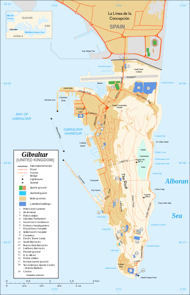
Čeština: Mapa ostrova Gibraltar v angličtině.
English: Map in English of Gibraltar.
Français : * Sujet : Carte en anglais de Gibraltar ;
  • Sources : Création personnelle ;
  • Carte créée à partir de captures d'écran d'images satellite de Google Earth d'un point de vue placé à 1,18 km d'altitude (imagerie disponible de novembre 2007) ;
  • Références complémentaires :
  • Échelle approximative : 1:40 000 (précision : environ 10 m) ;
  • Note : Largeur du tracé des routes proportionnelle à la réalité ;
  • Auteur : Eric Gaba (fr:Sting) ;
  • Date : Novembre 2007.
Português: Mapa (em Inglês) de Gibraltar.
ದಿನಾಂಕ
ಆಕರ Own work ;
Map created using screenshots of Google Earth satellite imagery from a point of view located at 1.18 km of altitude (available imagery of November 2007) ;
Other references :
* CIA map ;
* Gibnet map ;
* U.K. MoD map
Locator map : Image:Blank_map_of_South_Europe_and_North_Africa.svg (modified) created by Historicair ;
Approximate scale : 1:40,000 (accuracy : about 10 m)
Note : The roads width is proportional to reality
ಕರ್ತೃ Eric Gaba (Sting)
ಅನುಮತಿ
(ಈ ಕಡತವನ್ನು ಮರುಬಳಕೆ ಮಾಡಲಾಗುತ್ತಿದೆ)
Attribution and Share-Alike required
ಇತರೆ ಆವೃತ್ತಿಗಳು

[ಸಂಪಾದಿಸಿ]

Disputed isthmus and land
SVG genesis
InfoField
 
The SVG code is valid.
 
This map was created with Inkscape…important.
 
 This map uses embedded text that can be easily translated using a text editor.

ಪರವಾನಗಿ

I, the copyright holder of this work, hereby publish it under the following licenses:
GNU head GNU ಉಚಿತ ಡಾಕ್ಯುಮೆಂಟೇಶನ್ ಪರವಾನಗಿ, ಆವೃತ್ತಿಯ ನಿಯಮಗಳ ಅಡಿಯಲ್ಲಿ ಈ ಡಾಕ್ಯುಮೆಂಟ್ ಅನ್ನು ನಕಲಿಸಲು, ವಿತರಿಸಲು ಮತ್ತು/ಅಥವಾ ಮಾರ್ಪಡಿಸಲು ಅನುಮತಿಯನ್ನು ನೀಡಲಾಗಿದೆ. 1.2 ಅಥವಾ ಯಾವುದೇ ನಂತರದ ಆವೃತ್ತಿಯನ್ನು ಉಚಿತ ಸಾಫ್ಟ್‌ವೇರ್ ಫೌಂಡೇಶನ್ ಪ್ರಕಟಿಸಿದೆ; ಯಾವುದೇ ಅಸ್ಥಿರ ವಿಭಾಗಗಳಿಲ್ಲದೆ, ಮುಖ ಪಠ್ಯಗಳಿಲ್ಲ ಮತ್ತು ಹಿಂದಿನ ಕವರ್ ಪಠ್ಯಗಳಿಲ್ಲ. ಪರವಾನಗಿಯ ಪ್ರತಿಯನ್ನು GNU ಉಚಿತ ಡಾಕ್ಯುಮೆಂಟೇಶನ್ ಪರವಾನಗಿ ಎಂಬ ವಿಭಾಗದಲ್ಲಿ ಸೇರಿಸಲಾಗಿದೆ.
w:en:Creative Commons
ವೈಶಿಷ್ಟ್ಯ ಇರುವುದರಂತೆಯೇ ಹಂಚು
This file is licensed under the Creative Commons Attribution-Share Alike 4.0 International, 3.0 Unported, 2.5 Generic, 2.0 Generic and 1.0 Generic license.
ನೀವು ಮುಕ್ತ:
  • ಹಂಚಿಕೆಗೆ – ಕೆಲಸವನ್ನು ನಕಲು ಮಾಡಲು, ವಿತರಣೆ ಮತ್ತು ಸಾಗಿಸಲು
  • ರೀಮಿಕ್ಸ್ ಮಾಡಲು – ಕೆಲಸವನ್ನು ಬಳಸಿಕೊಳ್ಳಲು
ಈ ಕೆಳಗಿನ ಷರತ್ತುಗಳಲ್ಲಿ:
  • ವೈಶಿಷ್ಟ್ಯ – ನೀವು ಸೂಕ್ತವಾದ ಕ್ರೆಡಿಟ್ ನೀಡಬೇಕು, ಪರವಾನಗಿಗೆ ಲಿಂಕ್ ಅನ್ನು ಒದಗಿಸಬೇಕು ಮತ್ತು ಯಾವುದೇ ಬದಲಾವಣೆಗಳನ್ನು ಮಾಡಿದ್ದರೆ ಸೂಚಿಸಬೇಕು. ನೀವು ಯಾವುದೇ ಸಮಂಜಸವಾದ ರೀತಿಯಲ್ಲಿ ಮಾಡಬಹುದು, ಆದರೆ ಪರವಾನಗಿದಾರರು ನಿಮ್ಮನ್ನು ಅಥವಾ ನಿಮ್ಮ ಯಾವುದೇ ಬಳಕೆಯನ್ನು ಅನುಮೋದಿಸಿದಂತೆ ರೀತಿಯಲ್ಲಿ ಉಪಯೋಗಿಸಬಾರದು.
  • ಇರುವುದರಂತೆಯೇ ಹಂಚು – ನೀವು ರೀಮಿಕ್ಸ್ ಮಾಡಿದರೆ, ರೂಪಾಂತರಗೊಳಿಸಿದರೆ ಅಥವಾ ವಸ್ತುವಿನ ಮೇಲೆ ನಿರ್ಮಿಸಿದರೆ, ನಿಮ್ಮ ಕೊಡುಗೆಗಳನ್ನು ನೀವು ಮೂಲದಂತೆ ಅದೇ ಅಥವಾ ಹೊಂದಾಣಿಕೆಯ ಪರವಾನಗಿ ಅಡಿಯಲ್ಲಿ ವಿತರಿಸಬೇಕು.
ನಿಮ್ಮಿಚ್ಛೆಯ ಪರವಾನಗಿಯನ್ನು ನೀವು ಆರಿಸಿಕೊಳ್ಳಬಹುದು.

Captions

Add a one-line explanation of what this file represents

Items portrayed in this file

depicts ಇಂಗ್ಲಿಷ್

copyright status ಇಂಗ್ಲಿಷ್

copyrighted ಇಂಗ್ಲಿಷ್

Commons quality assessment ಇಂಗ್ಲಿಷ್

Wikimedia Commons featured picture ಇಂಗ್ಲಿಷ್

ನವೆಂಬರ್ 2007

coordinates of the point of view ಇಂಗ್ಲಿಷ್

36°7'59.999"N, 5°21'0.000"W

media type ಇಂಗ್ಲಿಷ್

image/svg+xml

ಕಡತದ ಇತಿಹಾಸ

ದಿನ/ಕಾಲ ಒತ್ತಿದರೆ ಆ ಸಮಯದಲ್ಲಿ ಈ ಕಡತದ ವಸ್ತುಸ್ಥಿತಿ ತೋರುತ್ತದೆ.

ದಿನ/ಕಾಲಕಿರುನೋಟಆಯಾಮಗಳುಬಳಕೆದಾರಟಿಪ್ಪಣಿ
ಪ್ರಸಕ್ತ೦೧:೪೦, ೨೨ ಫೆಬ್ರವರಿ ೨೦೨೦೦೧:೪೦, ೨೨ ಫೆಬ್ರವರಿ ೨೦೨೦ ವರೆಗಿನ ಆವೃತ್ತಿಯ ಕಿರುನೋಟ೨,೦೨೦ × ೩,೧೪೦ (೨೮೯ KB)JoKalliauermalformed svg (compare firefox/chrome rendering with librsvg-rendering) actually firefox/chrome were correct, also it looks wrong
೧೧:೩೧, ೨೯ ಜೂನ್ ೨೦೧೭೧೧:೩೧, ೨೯ ಜೂನ್ ೨೦೧೭ ವರೆಗಿನ ಆವೃತ್ತಿಯ ಕಿರುನೋಟ೨,೦೨೦ × ೩,೧೪೦ (೫೩೮ KB)Wereldburger758Removal error in file. Valid SVG now.
೦೩:೨೨, ೨೮ ಆಗಸ್ಟ್ ೨೦೦೮೦೩:೨೨, ೨೮ ಆಗಸ್ಟ್ ೨೦೦೮ ವರೆಗಿನ ಆವೃತ್ತಿಯ ಕಿರುನೋಟ೨,೦೨೦ × ೩,೧೪೦ (೫೬೯ KB)RedCoatRemove "claimed by Spain", completely gratuitous for a map
೧೬:೫೮, ೧೧ ಡಿಸೆಂಬರ್ ೨೦೦೭೧೬:೫೮, ೧೧ ಡಿಸೆಂಬರ್ ೨೦೦೭ ವರೆಗಿನ ಆವೃತ್ತಿಯ ಕಿರುನೋಟ೨,೦೨೦ × ೩,೧೪೦ (೫೭೦ KB)StingNotification of the Spanish claims
೨೦:೧೦, ೨೭ ನವೆಂಬರ್ ೨೦೦೭೨೦:೧೦, ೨೭ ನವೆಂಬರ್ ೨೦೦೭ ವರೆಗಿನ ಆವೃತ್ತಿಯ ಕಿರುನೋಟ೨,೦೨೦ × ೩,೧೪೦ (೫೬೯ KB)StingAdditional names ; up-to-date corrections
೦೩:೦೫, ೨೭ ನವೆಂಬರ್ ೨೦೦೭೦೩:೦೫, ೨೭ ನವೆಂಬರ್ ೨೦೦೭ ವರೆಗಿನ ಆವೃತ್ತಿಯ ಕಿರುನೋಟ೨,೦೨೦ × ೩,೧೪೦ (೫೬೧ KB)RedCoatHouse of Assembly → Gibraltar Parliament
೦೧:೨೧, ೨೭ ನವೆಂಬರ್ ೨೦೦೭೦೧:೨೧, ೨೭ ನವೆಂಬರ್ ೨೦೦೭ ವರೆಗಿನ ಆವೃತ್ತಿಯ ಕಿರುನೋಟ೨,೦೨೦ × ೩,೧೪೦ (೫೬೧ KB)Sting+ info
೧೯:೪೨, ೨೬ ನವೆಂಬರ್ ೨೦೦೭೧೯:೪೨, ೨೬ ನವೆಂಬರ್ ೨೦೦೭ ವರೆಗಿನ ಆವೃತ್ತಿಯ ಕಿರುನೋಟ೨,೦೨೦ × ೩,೧೪೦ (೫೬೧ KB)Sting+ info
೧೮:೫೧, ೨೬ ನವೆಂಬರ್ ೨೦೦೭೧೮:೫೧, ೨೬ ನವೆಂಬರ್ ೨೦೦೭ ವರೆಗಿನ ಆವೃತ್ತಿಯ ಕಿರುನೋಟ೨,೦೨೦ × ೩,೧೪೦ (೫೬೧ KB)Sting{{Information |Description=Map in English of Gibraltar |Source=Own work ;<br/>Map created using screenshots of Google Earth satellite imagery from a point of view located at 1.18 km of altitude (available image

ಈ ಫೈಲನ್ನು ಬಳಸುವ ಯಾವ ಪುಟಗಳೂ ಇಲ್ಲ.

ಜಾಗತಿಕ ಕಡತ ಉಪಯೋಗ

ಈ ಕಡತವನ್ನು ಕೆಳಗಿನ ಬೇರೆ ವಿಕಿಗಳೂ ಉಪಯೋಗಿಸುತ್ತಿವೆ:

ಮೇಲ್ದರ್ಜೆ ಮಾಹಿತಿ

"https://kn.wikipedia.org/wiki/ಚಿತ್ರ:Gibraltar_map-en.svg" ಇಂದ ಪಡೆಯಲ್ಪಟ್ಟಿದೆ