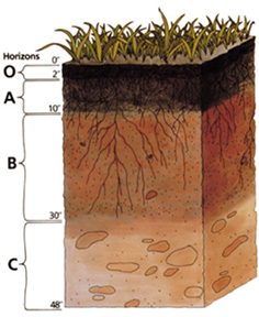
ಚಿತ್ರ:Soil profile.jpg
Soil_profile.jpg (೨೩೬ × ೨೮೮ ಚಿತ್ರಬಿಂದು, ಫೈಲಿನ ಗಾತ್ರ: ೩೯ KB, MIME ಪ್ರಕಾರ: image/jpeg)
ಕಡತದ ಇತಿಹಾಸ
ದಿನ/ಕಾಲ ಒತ್ತಿದರೆ ಆ ಸಮಯದಲ್ಲಿ ಈ ಕಡತದ ವಸ್ತುಸ್ಥಿತಿ ತೋರುತ್ತದೆ.
| ದಿನ/ಕಾಲ | ಕಿರುನೋಟ | ಆಯಾಮಗಳು | ಬಳಕೆದಾರ | ಟಿಪ್ಪಣಿ | |
|---|---|---|---|---|---|
| ಪ್ರಸಕ್ತ | ೦೬:೦೫, ೨೪ ನವೆಂಬರ್ ೨೦೦೪ |  | ೨೩೬ × ೨೮೮ (೩೯ KB) | Paleorthid | Soil profile 236x288 38.76 KB {{PD-USGov-USDA}} |
ಕಡತ ಬಳಕೆ
ಈ ಕೆಳಗಿನ ಪುಟವು ಈ ಚಿತ್ರಕ್ಕೆ ಸಂಪರ್ಕ ಹೊಂದಿದೆ:
ಜಾಗತಿಕ ಕಡತ ಉಪಯೋಗ
ಈ ಕಡತವನ್ನು ಕೆಳಗಿನ ಬೇರೆ ವಿಕಿಗಳೂ ಉಪಯೋಗಿಸುತ್ತಿವೆ:
- af.wikipedia.org ಮೇಲೆ ಬಳಕೆ
- ar.wikipedia.org ಮೇಲೆ ಬಳಕೆ
- ast.wikipedia.org ಮೇಲೆ ಬಳಕೆ
- as.wikipedia.org ಮೇಲೆ ಬಳಕೆ
- az.wikipedia.org ಮೇಲೆ ಬಳಕೆ
- be-tarask.wikipedia.org ಮೇಲೆ ಬಳಕೆ
- be.wikipedia.org ಮೇಲೆ ಬಳಕೆ
- bh.wikipedia.org ಮೇಲೆ ಬಳಕೆ
- bjn.wikipedia.org ಮೇಲೆ ಬಳಕೆ
- bn.wikipedia.org ಮೇಲೆ ಬಳಕೆ
- ca.wikipedia.org ಮೇಲೆ ಬಳಕೆ
- cs.wikipedia.org ಮೇಲೆ ಬಳಕೆ
- cy.wikipedia.org ಮೇಲೆ ಬಳಕೆ
- da.wikipedia.org ಮೇಲೆ ಬಳಕೆ
- de.wikipedia.org ಮೇಲೆ ಬಳಕೆ
- Podsol
- Boden (Bodenkunde)
- Solonetz
- USDA Soil Taxonomy
- Inceptisol
- Entisol
- Andisol
- Gelisol
- Alfisol
- Oxisol
- Histosol
- Spodosol
- Ultisol
- Aridisol
- Vertisol
- Mollisol
- Portal:Geowissenschaften
- Portal:Geowissenschaften/Disziplinen
- Benutzer:BK-Thorsten/Entwurf
- Benutzer:BK-Thorsten
- Acrisol
- Ferralsol
- Nitisol
- Cryosol
- Benutzer:Flaovia/Humus
ಈ ಫೈಲ್ನ ಹೆಚ್ಚು ಜಾಗತಿಕ ಬಳಕೆಯನ್ನು ವೀಕ್ಷಿಸಿ.


