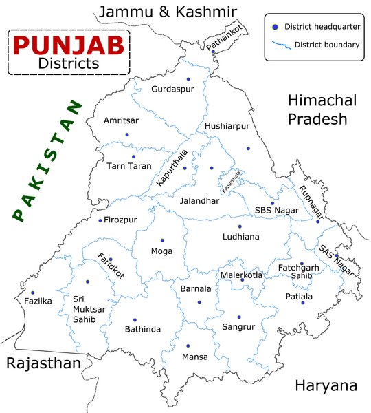
ಚಿತ್ರ:Punjab district map.png

ಈ ಮುನ್ನೋಟ ಗಾತ್ರ:೫೪೦ × ೬೦೦ ಪಿಕ್ಸೆಲ್ಗಳು. ಇತರ ರೆಸಲ್ಯೂಶನ್ಗಳು: ೨೧೬ × ೨೪೦ ಪಿಕ್ಸೆಲ್ಗಳು | ೪೩೨ × ೪೮೦ ಪಿಕ್ಸೆಲ್ಗಳು | ೬೯೧ × ೭೬೮ ಪಿಕ್ಸೆಲ್ಗಳು | ೯೨೨ × ೧,೦೨೪ ಪಿಕ್ಸೆಲ್ಗಳು | ೨,೪೬೭ × ೨,೭೪೧ ಪಿಕ್ಸೆಲ್ಗಳು.
ಮೂಲ ಕಡತ (೨,೪೬೭ × ೨,೭೪೧ ಚಿತ್ರಬಿಂದು, ಫೈಲಿನ ಗಾತ್ರ: ೬೩೫ KB, MIME ಪ್ರಕಾರ: image/png)
ಕಡತದ ಇತಿಹಾಸ
ದಿನ/ಕಾಲ ಒತ್ತಿದರೆ ಆ ಸಮಯದಲ್ಲಿ ಈ ಕಡತದ ವಸ್ತುಸ್ಥಿತಿ ತೋರುತ್ತದೆ.
| ದಿನ/ಕಾಲ | ಕಿರುನೋಟ | ಆಯಾಮಗಳು | ಬಳಕೆದಾರ | ಟಿಪ್ಪಣಿ | |
|---|---|---|---|---|---|
| ಪ್ರಸಕ್ತ | ೧೪:೫೫, ೧೦ ಜನವರಿ ೨೦೨೩ |  | ೨,೪೬೭ × ೨,೭೪೧ (೬೩೫ KB) | Saad Ali Khan Pakistan | updated district MalerKotla on map |
| ೧೦:೧೫, ೭ ಜುಲೈ ೨೦೨೦ |  | ೨,೪೬೭ × ೨,೭೪೧ (೮೬೭ KB) | Kaushal Bishnoi | New Update version of Punjab District Map with 22 District. | |
| ೨೦:೧೧, ೫ ಅಕ್ಟೋಬರ್ ೨೦೧೩ |  | ೧,೦೯೪ × ೮೪೮ (೧೨೭ KB) | Ras67 | cropped and optimized | |
| ೧೪:೧೦, ೨೮ ಏಪ್ರಿಲ್ ೨೦೦೮ |  | ೧,೨೧೧ × ೮೭೪ (೧೮೭ KB) | Wikigringo | Uploading a better color version of the file with bigger font size. | |
| ೨೧:೩೧, ೨೬ ಏಪ್ರಿಲ್ ೨೦೦೮ |  | ೧,೨೬೯ × ೯೦೭ (೧೬೭ KB) | Wikigringo | {{Information |Description=State of Punjab, India with districts marked along with district HQ. |Source=Self made using Inkscape. Source map referred from Punjab govt. site. |Date=04/26/2008 |Author=Wikigringo |Permission= |other_versions= }} |
ಕಡತ ಬಳಕೆ
ಜಾಗತಿಕ ಕಡತ ಉಪಯೋಗ
ಈ ಕಡತವನ್ನು ಕೆಳಗಿನ ಬೇರೆ ವಿಕಿಗಳೂ ಉಪಯೋಗಿಸುತ್ತಿವೆ:
- ar.wikipedia.org ಮೇಲೆ ಬಳಕೆ
- azb.wikipedia.org ಮೇಲೆ ಬಳಕೆ
- bh.wikipedia.org ಮೇಲೆ ಬಳಕೆ
- bn.wikipedia.org ಮೇಲೆ ಬಳಕೆ
- ca.wikipedia.org ಮೇಲೆ ಬಳಕೆ
- ceb.wikipedia.org ಮೇಲೆ ಬಳಕೆ
- en.wikipedia.org ಮೇಲೆ ಬಳಕೆ
- es.wikipedia.org ಮೇಲೆ ಬಳಕೆ
- eu.wikipedia.org ಮೇಲೆ ಬಳಕೆ
- fa.wikipedia.org ಮೇಲೆ ಬಳಕೆ
- fi.wikipedia.org ಮೇಲೆ ಬಳಕೆ
- fr.wikipedia.org ಮೇಲೆ ಬಳಕೆ
- Pendjab (Inde)
- District de Barnala
- District de Faridkot
- District de Fatehgarh Sahib
- District de Fazilka
- District de Firozpur
- District de Gurdaspur
- District de Hoshiarpur
- District de Jalandhar
- District de Kapurthala
- District de Ludhiana
- District de Mansa (Penjab)
- District de Moga
- District de Mohali
- District de Muktsar
ಈ ಫೈಲ್ನ ಹೆಚ್ಚು ಜಾಗತಿಕ ಬಳಕೆಯನ್ನು ವೀಕ್ಷಿಸಿ.


